Not many people know of the closest waterfall to the city of Boston. I certainly didn't, until buying the Hiking Waterfalls of New England trail book. That's when I first learned of the Cascade– so of course I had to place my first EarthCache here.
(Note the  and
and  attributes!)

The photo above shows the Cascade after lots of rain. During dry season, one may not experience much water falling at the Cascade. The falls are most active in wet periods.
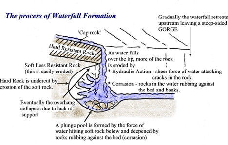
Formation of Waterfalls
1. Waterfalls are found in the upper course of a river. They usually occur where a band of hard rock lies next to soft rock. They may often start as rapids. The Cascade is no different.
2. As the river passes over the hard rock, the soft rock below is eroded (worn away) more quickly than the hard rock leaving the hard rock elevated above the stream bed below.
3. The 'step' in the river bed continues to develop as the river flows over the hard rock step (Cap Rock) as a vertical drop.
4. The drop gets steeper as the river erodes the soft rock beneath by processes such as abrasion and hydraulic action. A plunge pool forms at the base of the waterfall. The plunge pool at the Cascade is much smaller than other notable New England waterfalls.
5. This erosion gradually undercuts the hard rock and the plunge pool gets bigger due to further hydraulic action and abrasion. Eventually the hard cap rock is unsupported and collapses. The rocks that fall into the plunge pool will continue to enlarge it by abrasion as they are swirled around. A steep sided valley known as a gorge is left behind and as the process continues the waterfall gradually retreats upstream.
My main source for this info is the Glen Ellis Falls EarthCache (GC283HB) in the White Mountains, New Hampshire, which I found on 8/9/19.
Seconday source: The Cascade – Melrose, Massachusetts
Logging requirements
In order to log this EarthCache, just answer these questions. You may message or email me the answers and log your find before I get back to you.
1. Standing at the posted coordinates, about how high is the water plunge directly in front of you?
2. The constant flowing of the water causes the rock it flows over to change color. Observe, what color is the rock directly behind the falling water?
3. The gradual destruction of this rock by the waterfall is a process called _______.
4. Go to the top of the Cascade using the uphill hiking trail on the left side of the falls (see the provided waypoint). There is no need to climb the actual falls or get wet. Along the way, read the sign to answer, which rock is 0.2 miles away? ______ Rock
5. Now that you're at the top of the Cascade, about how far are you above the bottom of the falls? (Do NOT stand too close to the ledge to answer this question! Your safety is the most important. Just send an estimate.)
6. Post a picture with yourself and the Cascade in the background. Your face does NOT have to be present, in accordance with geocaching rules. Instead, you may hold your GPSr or give a thumb’s up to prove you actually visited.