La nappe de Digne
Les Alpes sont des montagnes relativement jeunes du point de vue géologique. Elles résultent de la convergence et de la collision entre les plaques africaine et européenne. Leur formation est le fruit de plusieurs étapes tectoniques qui ont mené à l’obtention d’une architecture complexe qui continue d’évoluer à l’heure actuelle.
Pour comprendre la formation des Alpes il est nécessaire de connaître la situation géodynamique qui l'a précédée.
Première étape : fragmentation de la Pangée et ouverture océanique
Il y a plus de 220 millions d'années (Ma), tous les continents à la surface du globe étaient regroupés en un seul supercontinent la « Pangée ».
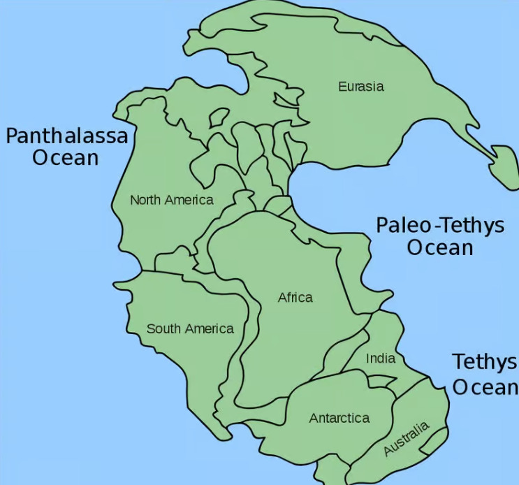
ARCHITECTURE DU SUPERCONTINENT PANGÉE
Sous l'effet des forces tectoniques, ce supercontinent se fragmente à la fin du Trias (220 Ma) et plusieurs océans commencent à se former, comme l'océan Atlantique, mais aussi localement un petit océan, la Téthys alpine.
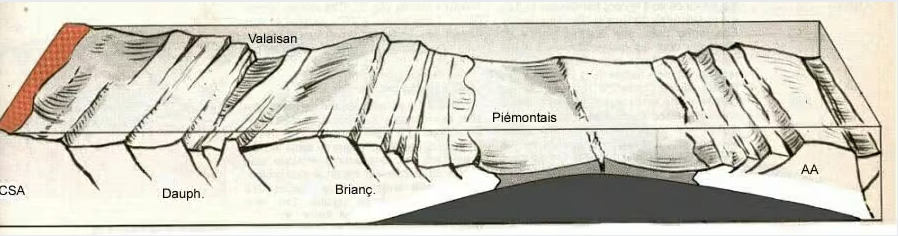
PHASE D’EXTENSION PRÉ-ALPINE AVEC L’OUVERTURE DE L’OCÉAN DE LA TÉTHYS ALPINE ENTRE 165 ET 120 MA. © CHRISTIAN NICOLLET
Les restes de ces océans sont visibles en de nombreux endroits des Alpes grâce aux sédiments qui se sont déposés sur le plancher océanique.
Deuxième étape : compression et initiation d’une subduction
La plaque africaine se rapproche de l'Europe (environ 90 Ma) et la plaque européenne s'enfonce sous la plaque adriatique qui est associée à la plaque africaine. C’est ce que l’on appelle une subduction.
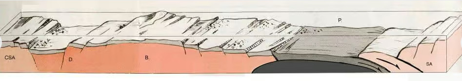
PHASE COMPRESSIVE AVEC INITIATION D’UNE SUBDUCTION, LA PLAQUE EUROPÉENNE S’ENFONCE SOUS LA PLAQUE ADRIATIQUE ET L’OCÉAN ALPIN (P) COMMENCE À SE REFERMER. © CHRISTIAN NICOLLET
Au fur et à mesure de l'évolution de la subduction, la Téthys alpine se referme. Des parties entières continentales et de plancher océanique vont ainsi disparaître dans la fosse de subduction.
Certaines couches océaniques vont au contraire passer au-dessus et finalement chevaucher des couches continentales. On parle alors d'obduction.
Troisième étape : collision continentale et formation de la chaîne des Alpes
La fermeture totale de la Téthys alpine (environ 30 Ma) est suivie par la collision des plaques européenne et africaine ce qui marque le début de la formation des Alpes. La rencontre des deux masses continentales va ainsi engendrer une importante déformation des unités sédimentaires et cristallines (les roches du socle continental) : phénomènes de charriage de nappes, intenses plissements et chevauchements.
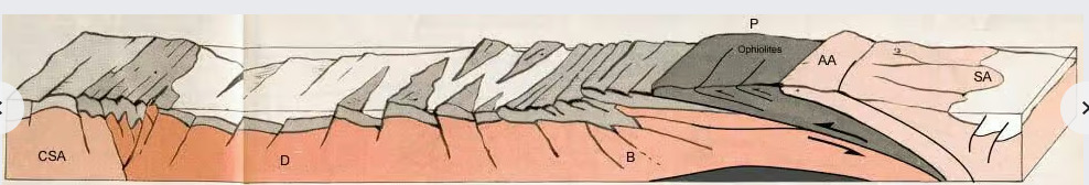
DÉBUT DE LA PHASE DE COLLISION, LA TÉTHYS ALPINE S’EST ENTIÈREMENT FERMÉE, UNE PARTIE DES ROCHES DE L’ANCIEN PLANCHER OCÉANIQUE PASSE EN SUBDUCTION ALORS QU’UNE AUTRE EST OBDUCTÉE. INTENSE DÉFORMATION AVEC DÉVELOPPEMENT DE CHEVAUCHEMENTS, DE PLIS ET DE CHARRIAGES. © CHRISTIAN NICOLLET
Petit à petit, la déformation se propage vers les parties les plus externes du massif en cours de formation, menant au soulèvement d'une série de hauts sommets comme le Mont Blanc, puis se poursuit au Miocène supérieur (12 Ma) par la formation des chaînes d'avant-pays comme la nappe de Digne.
Histoire actuelle : déformation cisaillante et extensive
La géodynamique actuelle des Alpes est désormais dominée non plus par un régime compressif mais par une déformation cisaillante et extensive, en lien avec le mouvement de rotation anti-horaire de la plaque adriatique. Les masses terrestres sont ajustées par la fonte des glaciers et l'érosion.
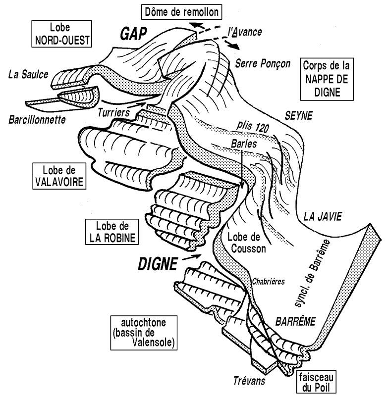
La nappe de Digne
La nappe de Digne est une épaisse dalle rocheuse, de l'ordre de 5000 m d'épaisseur totale.
Géographiquement elle s'étend depuis Digne jusqu'à la vallée de l'Ubaye, où elle s'enfonce sous d’autres nappes au Nord Est à proximité de Gap.
Il y a environ 10 Ma, elle s’est mise en mouvement en glissant sur son socle rigide sur plusieurs kilomètres.
Ses contours dessinent des lobes, des déchirures et des chevauchements.
La tectonique de la nappe se poursuit encore de nos jours et donne lieu à des mouvements sismiques.
Questions
Question 1 : Vous vous trouvez maintenant devant une formation géologique appartenant à la nappe de Digne. Pouvez-vous la décrire ?
Question 2 : à quelle étape de la formation des Alpes pensez-vous que cette formation géologique s’est formée ? Y a t il des plaques terrestres qui ont eu une incidence sur cette formation ? Si c’est le cas, quelles sont-elles ?
Question 3 : Comment qualifieriez-vous la nappe de Digne ? Est-elle lisse ou plissée, découpée ….?
Question 4 (optionnelle) : une photo de vous ou d'un objet vous appartenant devant la formation géologique serait appréciée.
Vous pouvez vous loguer "found it" et m'envoyer vos réponses soit via mon profil, soit via la messagerie geocaching.com (message Center), et je vous contacterai en cas de problème.
Rappel : une EarthCache consiste en une leçon de géologie, qui nécessite une visite sur un lieu géologique unique. Les EarthCaches n'ont pas de contenant ou de logbook.
The Digne nappe
The Alps are relatively young mountains in geological terms. They are the result of the convergence and collision of the African and European plates. Their formation is the result of several tectonic stages that led to a complex architecture that continues to evolve today.
To understand the formation of the Alps, it is necessary to understand the geodynamic situation that preceded it.
First stage: fragmentation of Pangea and oceanic opening
More than 220 million years ago (Ma), all the continents on the surface of the globe were grouped together in a single supercontinent called Pangea.
ARCHITECTURE OF THE SUPERCONTINENT PANGEA
Under the effect of tectonic forces, this supercontinent broke up at the end of the Triassic period (220 Ma), and several oceans began to form, including the Atlantic Ocean and, locally, a small ocean, the Alpine Tethys.
PHASE OF PRE-ALPINE EXTENSION WITH THE OPENING OF THE ALPINE TETHYS OCEAN BETWEEN 165 AND 120 MA. CHRISTIAN NICOLLET
The remains of these oceans are visible in many parts of the Alps, thanks to the sediments deposited on the ocean floor.
Second stage: compression and initiation of subduction
The African plate moves closer to Europe (around 90 Ma) and the European plate sinks beneath the Adriatic plate, which is associated with the African plate. This is known as subduction.
COMPRESSIVE PHASE WITH INITIATION OF SUBDUCTION, THE EUROPEAN PLATE SINKS BENEATH THE ADRIATIC PLATE AND THE ALPINE OCEAN (P) BEGINS TO CLOSE. CHRISTIAN NICOLLET
As subduction progresses, the Alpine Tethys closes in. Entire continental and seafloor sections disappear into the subduction trench.
Some oceanic layers, on the other hand, will pass over and eventually overlap continental layers. This is known as obduction.
Third stage: continental collision and formation of the Alps
The complete closure of the Alpine Tethys (around 30 Ma) is followed by the collision of the European and African plates, marking the start of the formation of the Alps. The meeting of the two continental masses resulted in major deformation of the sedimentary and crystalline units (the rocks of the continental basement): nappe thrusting phenomena, intense folding and thrusting.
AT THE START OF THE COLLISION PHASE, THE ALPINE TETHYS IS COMPLETELY CLOSED, AND PART OF THE FORMER OCEAN FLOOR IS SUBDUCTED, WHILE ANOTHER PART IS OBDUCTED. INTENSE DEFORMATION WITH THE DEVELOPMENT OF OVERLAPS, FOLDS AND THRUSTS © CHRISTIAN NICOLLET
Deformation gradually spread to the outermost parts of the massif as it formed, leading to the uplift of a series of high peaks such as Mont Blanc, before continuing into the Upper Miocene (12 Ma) with the formation of foreland chains such as the Digne nappe.
Present-day history: shearing and extensive deformation
Current geodynamics in the Alps are no longer dominated by a compressive regime, but by extensive shearing deformation, linked to the counter-clockwise rotation of the Adriatic plate. Land masses are adjusted by glacial melt and erosion.
The Digne nappe
The Digne nappe is a thick slab of rock, around 5,000 m thick in total.
Geographically, it extends from Digne to the Ubaye valley, where it sinks beneath other nappes to the northeast near Gap.
Around 10 million years ago, it began to move, sliding over its rigid base for several kilometers.
Its contours are lobed, torn and overlapped.
The tectonics of the nappe continue to this day, giving rise to seismic movements.
Questions
Question 1: You are now looking at a geological formation belonging to the Digne nappe. Can you describe it?
Question 2: At what stage in the formation of the Alps do you think this geological formation was formed? Are there any terrestrial plates that had an impact on this formation? If so, which ones?
Question 3: How would you describe the Digne nappe? Is it smooth, folded or indented ....?
Question 4 (optional): A photo of yourself or something you own in front of the geological formation would be appreciated.
You can log in "found it" and send me your answers either via my profile or via the geocaching.com messaging system (message Center), and I'll contact you if there are any problems.
An EarthCache is a geology lesson, involving a visit to a unique geological site. EarthCaches have no container or logbook.