 tämä on Earthcache joten et löydä paikalta kätkölaatikkoa tai logikirjaa tähän kätköön liittyen. Tällä Eartcachella käynti osoitetaan suorittamalla kätkökuvauksessa kerrotut tehtävät. Eartcacheen eli maakätköön kuuluu oleellisena osana kohteen geologiaan liittyvä opetuksellisuus.
 This is an Earthcache so you won't find any items, box, physical cache or logbook at this site. you can log you visit by doing given tasks. Each EarthCache provides educational notes about current place geology.
 Kultaa!! - GOLD!! Lemmenjoki, Inari
Lemmenjokea tutkittiin Lapin kultaryntäyksen alkuvuosina 1870-luvun alussa. Sinne syntyi yli 70 valtausta ja kultaa kaivettiin kiivaasti kesällä 1902. Kultaa ei nytkään löytynyt ja alue painui unohduksiin.
Kultahistoriaan Lemmenjoki nousi toisen maailmansodan jälkeen. Inarinjoen varrella asuneet Ranttilan veljekset Uula, Veikko ja Niilo lähtivät loppukesällä 1945 nousemaan jokea ylös etsiäkseen kulta. Niilo puraisi hampaanjäljet juuri tältä paikalta Morgamojalta löytyneeseen 5 gramman kultahippuun syyskuun puolivälissä ja muutaman päivän aikana pussiin kertyi noin 30 g kultaa.

The River Lemmenjoki was studied in the early years of the Lapland Gold Rush in the early 1870s. More than 70 occupations took place there and gold was mined intensely in the summer of 1902. Even now, no gold was found and the area fell into oblivion.
Lemmenjoki entered gold history after the Second World War. The Ranttila brothers Uula, Veikko and Niilo, who lived by the Inari River, set out to climb the river in late summer 1945 in search of gold. Niilo bit his teeth marks on a 5 gram gold nugget found in just this very same spot at Morgamoja in mid-September, and within a few days about 30 g of gold accumulated in the bag.
Kultaa!! - Lemmenjoki, Inari
Kullan esiintyminen luonnossa
Kullan uskotaan syntyneen supernovan nukleosynteesissä ja neutronitähtien törmäyksessä, ja sitä on ollut läsnä pölyssä josta aurinkokunta muodostui. Koska maapallo oli sula, kun se muodostui, lähes kaikki varhaisessa maapallossa oleva kulta upposi todennäköisesti planeetan ytimeen. Siksi suurimman osan maankuoressa ja vaipassa olevasta kullasta uskotaan saapuneen maapallolle myöhemmin, asteroidien törmäyksissä myöhäisen raskaan pommituksen aikana, noin 4 miljardia vuotta sitten. Nykyään Kultaa esiintyy maapallolla niin ytimessä kuin vaipassa ja kuoressakin. Ytimen kulta on peräisin maapallon syntyajoilta, ja se vajosi sinne muiden raskaiden metallien kuten raudan tapaan. Vaipassa ja maankuoressa oleva kulta on peräisin 4 miljardia vuotta sitten maahan iskeytyneistä meteoriiteista.
Hyödynnettävissä oleva kulta esiintyy maankuoressa, irrallisina kultahippuina maaperässä, sekä meressä. Kulta esiintyy luonnossa yleensä metallisena, sekä lähes puhtaana kultana että metalliseoksina. Yleisimmin kulta esiintyy seoksena hopean kanssa, mutta vähäisissä määrin myös kuparin, raudan ja palladiumin kanssa. Maanpinnan kulta on muodostunut syvällä maankuoressa, josta se on noussut veden mukana ylös ja kiteytynyt, yleensä kvartsin sisään. Kun eroosio ja kemiallinen rapautuminen kuluttavat kalliota, kultasuonet paljastuvat ja kulta irtoaa ajan myötä. Näin syntyneet kultahiput asettuvat maaperään ja joenuomiin.
Alle kaksi prosenttia kullasta esiintyy kultahippuina. Kultahiput ovat 20–23 karaatin kultaa. Suurin koskaan löydetty kultahippu oli Australian Victoriasta vuonna 1869 löydetty ”Welcome Stranger”, jonka nettopaino oli 72,02 kilogrammaa. Suurin yhä olemassa oleva kultahippu on 27,21 kilogramman painoinen ”Hand of Faith”, joka löydettiin Victoriasta vuonna 1980. Suurin Suomesta löytynyt hippu on vuonna 1935 löytynyt 393-grammainen ”Evert”.
Miksi voimme löytää kultaa joista ja puroista?
Tämän geokohteen koordinaateissa on alueelle tyypillistä jokipengertä, josta täällä on löydetty kultaa. Juuti tältä paikalta Morgamojanvarresta tehtiin alueen ensimmäinen kultalöytö.
Kulta konsentroituu tiettyihin geotermisiin liuoksiin, jotka muodostuvat, kun magma ruiskuaa vettä sisältäviin kiviin. Magmaattinen lämpö käynnistää hydrotermisen kierron. Nämä kuumat nesteet liuottavat mineraaleja ja kiviä ja liuoksista tulee metallirikkaita. Jos tietyt olosuhteet vallitsevat, liuokset kuljettavat kultaa ensisijaisesti vesipitoisessa tilassa (liuoksena) esimerkiksi kloridikompleksina. Tämän kultapitoisen nesteen dekompressio ja jäähdytys johtaa alkuperäisen kullan saostumiseen.

Siksi kultaa löytyy yleensä metamorfisista kivistä, joihin hydrotermiset liuokset ovat vaikuttaneet. Sen lisäksi, että kulta esiintyy metamorfisissa kivissä, joskus kulta haalistuu. Sitten suuren tiheytensä vuoksi kulta kulkeutuu virtauksissa ja tiivistyy niin kutsuttuihin suoniin (eng. placer). Nämä ovat pengermäisissä jokisedimentteissä, joita esiintyy purojen ja jokien rannoilla. Geologiassa suoni "Placer" on arvokkaiden mineraalien kertyminen, joka muodostuu painovoiman erottamana tietystä lähdekivestä sedimenttiprosessien aikana. Nimi on peräisin espanjalaisesta sanasta placer, joka tarkoittaa "tulvahiekkaa".
Pengersuonien tyyppejä ovat "alluvium", "eluvium", rantasuoni ja paleosuoni.

Alluvium (latinalaisesta alluviuksesta, sanasta alluere, "pestä vastaan") on löysä, konsolidoimaton (ei sementoitu yhteen kiinteäksi kallioksi) maaperä tai sedimentti, joka on kulunut, muotoutunut uudelleen veden toimesta jossain muodossa ja kerrostunut uudelleen muuhun kuin meriympäristöön. Alluvium koostuu tyypillisesti erilaisista materiaaleista, mukaan lukien lietteen ja saven hienot hiukkaset sekä suuremmat hiekan ja soran hiukkaset. Kun tämä löysä tulvamateriaali kerrostuu tai sementoituu sitä kutsutaan alluviaaliseksi suoneksi.
Eluvium tai eluviaaliset kerrostumat ovat niitä geologisia kerrostumia ja maaperää, jotka ovat peräisin sään vaikutuksesta tai sään sekä painovoimaliikkeen aiheuttamasta yhdistelmästä. Eluviaatio tapahtuu, kun saostuminen ylittää haihtumisen.
Rantasuonia muodostuu merenrannoille, joissa aaltotoiminta ja rantavirrat siirtävät materiaaleja, kevyempiä nopeammin kuin raskaampia, muodostaen suonia.
Paleosuoni tai paleopacer on jäänne passiivisesta joesta tai virtakanavasta, jonka nuorempi sedimentti on täyttänyt tai haudannut. Sedimentit, joihin muinainen suoni on leikkaantunut tai hautautunut, voivat olla kiinteytymättömiä, puoliksi konsolidoituja, konsolidoituja tai litisoituja. Sana paleochannel on muodostettu sanasta paleo, joka tarkoittaa "vanhaa" ja kanavaa.
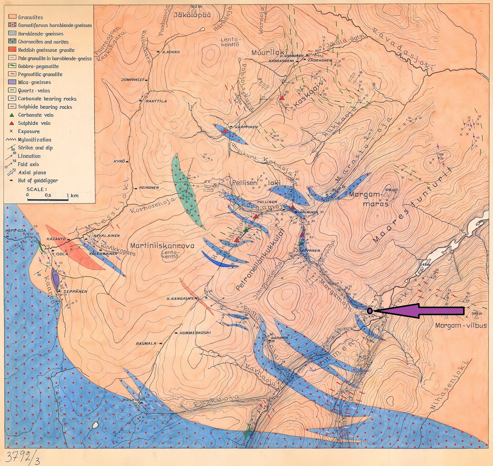
Lemmenjoen kulta on pienissä, tuntureilta Lemmenjokeen tai Vaskojokeen virtaavissa puroissa. Oheisissä kartoissa on kuvattuna alueen kallioperä ja kultavaltausten sijoittuminen alueella 1950-Luvulla. Tämän kätkön sijainti on merkitty karttoihin nuolella.


Jokivarressa olevan kiviaineksen karkeus vaihtelee riippuen siitä miten maa-aines on päässyt kulkeutumaan, kerrostumaan ja kulumaan aikojen saatossa. Kultapitoisimman maa-aineksen esiintymisen etäisyys jokivarresta vaihtelee siksi myös suuresti.

Kullan erottaminen vaskaamalla ja huuhtomalla
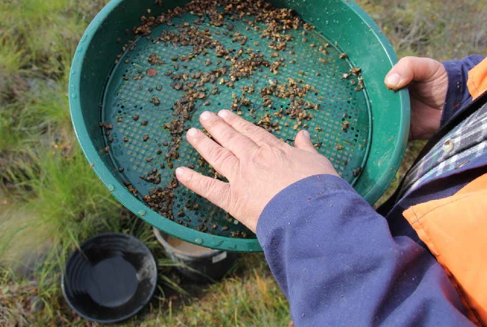
Kullanhuuhdonta on enimmäkseen manuaalinen tekniikka kullan erottamiseksi muista materiaaleista. Leveät, matalat vaskoolit täytetään hiekalla ja soralla, joka voi sisältää kultaa. Vaskooli upotetaan veteen ja ravistellaan, lajittelemalla kulta sorasta ja muusta materiaalista. Nykyään voit edelleen vaskata kultaa, mutta asioiden helpottamiseksi voidaan käyttää myös kultaluokittelijaa jonka jälkeen suodatettu materiaali vaskataan. Luokittelijoiden yleiset koot ovat 1/100", 1/70", 1/50", 1/30", 1/20", 1/12", 1/8", 1/4", 1/2". Esimerkiksi 1/2 tuuman verkko on noin 4 reikää neliötuumaa kohti; 1/4 tuuman verkossa on noin 16 reikää neliötuumaa kohti; 1/8 tuumaa sisältää noin 64 reikää neliötuumaa kohti ja niin edelleen. 1/100 tuumaa on pienin verkko, jota käytetään yleisesti mikroskooppiseen kullan talteenottoon ja erittäin hienoon kultapölyyn ja hiutaleisiin.

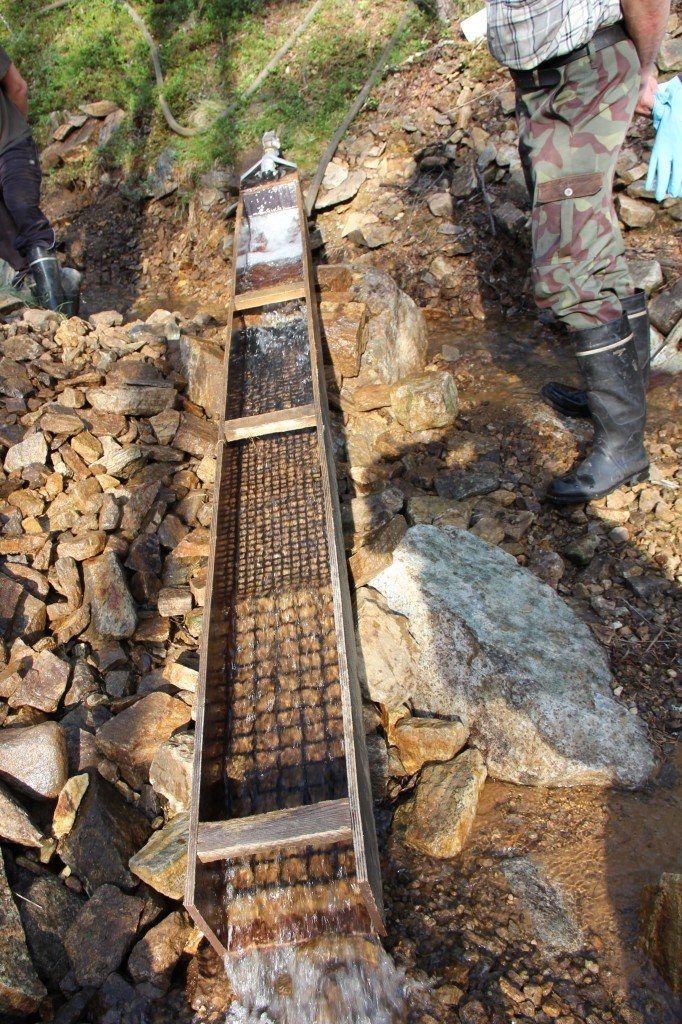
Rännihuuhdonnassakin kullan erottelu perustuu kullan ominaispainoon. Kulta on noin seitsemän kertaa painavampaa kuin normaali kiviaines. Kultapitoinen maa-aines lapioidaan tai muuten nostetaan huuhdontaränniin, jossa virtaa vesi. Vesi kuljettaa huuhdottavan maa-aineksen läpi rännin, kulta painavampana laskee rännin pohjalle. Rännin pohjalla on rihloja, jotka estävät veden vapaan virtauksen rännin pohjalla. Kulta painavana metallina ei pääse nousemaan rihlojen ylise ja se jään ”vangiksi” rihlojen väliin. Rihlat voivat olla metallista, muovista tai kumista. Ränni asennetaan tukevasti kivien päälle tai erillisten tukijalkojen varaan kaltevaan asentoon. Rännin kaltevuus pitää olla riittävän suuri. Rihlojen välit eivät saa tukkeutua. Aluksi rännin voi asentaa siten, että lasku on noin 10 cm metrillä. Jos rihlat tukkeutuvat, niin pitää lisätä veden määrää tai kaltevuutta. Useinmiten ollaan liian varovaisia ja rännitetään liian pienellä virtauksella ja kaltevuudella. Ränni tukkeutuu ja kulta saattaa mennä rihlojen ylise. Nyrkkisääntö voisi olla: Nyrkinkokoinen kivi pitäisi mennä rännin läpi.
Tärkeintä rännityksessä on, että kiviaines peseytyy kunnolla ja kaikki savikokkareetkin hajoavat. Peseytymistä voidaan tehostaa tekemällä rännin alkupäähän pesuallas tai laittaa ränniin ”pato” ruuveilla tai pitkulaisella kivellä. Maa-aines jää kiven taakse ja peseytyy hyvin. Nostamalla kiveä ylös aika-ajoin, niin rännissä maa-aines huuhtoutuu hyvin. Isot kivet heitetään erikseen pois rännistä.
Lemmenjoen kultaesiintymät
Lemmenjoki kullankaivajineen oli voimakkaasti esillä lehdissä, kirjoissa ja elokuvissa. Lapin Kullankaivajain Liitto perustettiin vilkkaimpana kaivuvuonna 1949 ajamaan kaivajien yhteisiä etuja, ratkaisemaan keskinäisiä erimielisyyksiä ja hoitamaan asiointia viranomaisten suuntaan. Vilkkaimmillaan Lemmenjoen kullankaivu oli vuosina 1949 – 1951, jonka jälkeen kultaryntäys hiipui jättäen jälkeensä muutamia ”elinkautisia”.
Parin vuosikymmenen hiljaiselon jälkeen kullankaivu Lemmenjoelle alkoi vilkastua 1970-luvulla. Tankavaaran kullanhuuhdontakisat, Kultamuseo, Kekkosen vierailut ja niiden tuoma julkisuus lisäsivät yleistä mielenkiintoa kullankaivua kohtaan. Uusi sukupolvi ehti oppia kullankaivun taidot vanhoilta veteraaneilta, uudet laitteet ja tekniikat antoivat mahdollisuuden kaivaa sellaisistakin paikoista, minne aiemmin ei päässyt.
Kullankaivu ja luonnonsuojelu ajautuivat ristiriitoihin 1980-luvulla. Lemmenjoen kansallispuistoa laajennettiin kaksi kertaa ja maamme suurin puisto nieli sisäänsä kullanhuuhdonta-alueet, jotka alueperin 1956 jätettiin rajojen ulkopuolelle. Puiston runkosuunnitelmassa 1987 esitettiin koneellisen kullankaivun lopettamista ja tämä oli lähtölaukaus vuosia kestäneille oikeusjutuille.
Uuden kaivoslain mukaan Lemmenjoen kansallispuistossa konekaivu päättyyi 10 vuotta kestävän jatkoajan jälkeen v. 2020. Kaivinkoneet vaikenivat, osa kaivajista loprtti, osa jatkoi lapiokaivua muutaen kaivospiirinsä lain edellyttämäksi kullanhuuhdonta-alueeksi, suurten kultahippujen löytöuutiset muuttuivat entistä harvinaisemmaksi.
Jotta voit kirjata tämän kätkön löydetyksi sinun
täytyy suorittaa seuraavat tehtävät annetuissa koordinaateissa:
Tämän geokohteen koordinaateissa on alueelle tyypillistä jokipengertä, josta täällä on löydetty kultaa. Juuti tältä paikalta Morgamojanvarresta tehtiin alueen ensimmäinen kultalöytö. Katsele annetuissa koordinaateissa ympärillesi, tee havaintoja ja ota näytteitä alle kuvattujen tehtävien mukaisesti.
1 )
Tämän geokohteen koordinaattien läheisyydessä tehtiin lemmenjoen ensimmäinen kultalöytö.
Perustuen siihen mitä näet paikalla,
Kerro minkätyyppiseen muodostumaan ja maaperään kultasuoni on syntynyt?
MIhin kiviainekseen kulta on täällä ollut sitoutunuttta? Voit käyttää avuksesi kuvauksessa olevaa kalllioperäkarttaa.
Mistä täältä löydetty kulta on mielestäsi tullut/kulkeutunut juuri tälle paikalle?
Kuinka kaukaa suhteessa joen rantaan kultaa mielestäsi löydettiin? miksi?
Miksi kultaa löydettiin ensimmäiseksi juuri täältä? Koordinaattien läheisyydessä on info taulu josta voi löytää lisäinformaatiota tästä.
Mihin havaintoihin perustat näkemyksesi?
2 )
Tutki näytteitä tälle paikalle kulkeutuvasta maaperästä koordinaattien lähellä virtaavasta joesta.
Kurkota varovasti veteen ja nappaa kourallinen hiekkaa joen pohjalta. Kuvaile hiekkaa (väri, muoto, koko, rakenne jne.) Jos on talvi tai et usko, että voit turvallisesti napata kourallista vedestä, tee parhaasi selittääksesi, miltä se näyttää
3)
Tutki näytteitä tällä paikalla pidempään olleessta maaperästä koordinaattien lähellä olevasta rantapenkereestä.
Kuvaile vastaavasti pengerhiekkaa noin 4 metrin päässä veden reunasta. Jos laittaisit tämän hiekan luokittelijaan, mitä kokoa käyttäisit? Miksi?
4)
Mikä tapa olisi mielestäsi paras löytää kultaa tänään? Selitä ajattelusi.
5 )
Lähetä vastauksesi kätkön omistajalle sivun yläreunan viestikeskuslinkillä
Sinun ei tarvitse odottaa kirjauslupaa, mutta asiattomat kirjaukset tullaan poistamaan. Omistaja vastaa jollain aikavälillä viestiin, jos vastauksissa on epäselvää.
6 )
Toivottavaa on myös että otat valokuvan itsestäsi ja/tai gps laitteestasi tältä paikalta, tai muusta kiinnostavassa kohteessa (mielellään liittyen kullankaivuuseen) puistossa ja liität sen kirjaukseesi. Älä paljasta vastauksia kirjaustehtäviin kuvallasi.
GOLD!! Lemmenjoki, Inari
The presence of gold in nature
Gold is thought to have been created by supernova nucleosynthesis and neutron star collision, and has been present in the dust that formed the solar system. Since the Earth was molten when it formed, almost all the gold in the early Earth probably sank into the core of the planet. Therefore, most of the gold in the Earth's crust and mantle is believed to have arrived on Earth later, in asteroid collisions during the late heavy bombardment, about 4 billion years ago. Today, gold is found on Earth in the core as well as in the mantle and crust. The gold in the core dates back to the birth of the Earth and sank there like other heavy metals such as iron. The gold in the mantle and crust comes from meteorites that hit Earth 4 billion years ago.
Recoverable gold occurs in the earth's crust, as loose gold nuggets in the soil, and in the ocean. Gold usually occurs in nature as metallic, both almost pure gold and alloys. Most commonly, gold occurs as an alloy with silver, but also to a minor extent with copper, iron and palladium. The gold on the earth's surface is formed deep in the earth's crust, from where it has risen up with water and crystallized, usually inside quartz. As erosion and chemical erosion erode the rock, gold veins are exposed and gold sheds over time. The gold nuggets thus created settle in the soil and riverbeds.
Less than two percent of gold is found in gold nuggets. Gold nuggets are 20–23 karat gold. The largest gold nugget ever found was the "Welcome Stranger" found in Victoria, Australia, in 1869, with a net weight of 72.02 kilograms. The largest gold nugget still in existence is the 27.21 kg "Hand of Faith", which was discovered in Victoria in 1980. The largest nugget found in Finland is the 393-gram "Evert" found in 1935.
Why can we find gold in rivers and streams?
In the coordinates of this geosite there is a river embankment typical of the region, where gold has been found here. Just from this place along Morgamoja, the first gold discovery in the area was made.
Gold concentrates in certain geothermal solutions formed when magma injects into rocks containing water. Magmatic heat initiates the hydrothermal cycle. These hot liquids dissolve minerals and rocks and the solutions become metal-rich. If certain conditions prevail, the solutions transport gold primarily in an aqueous state (in the form of a solution), for example, in the form of a chloride complex. Decompression and cooling of this gold-bearing liquid leads to precipitation of the original gold.

Therefore, gold is usually found in metamorphic rocks that have been affected by hydrothermal solutions. In addition to the fact that gold occurs in metamorphic rocks, sometimes gold fades. Then, due to its high density, gold travels in currents and condenses into so-called placers. These are found in the embankment river sediments found on the banks of streams and rivers. In geology, the vein "Placer" is the accumulation of valuable minerals formed by gravity separated from a particular source rock during sedimentary processes. The name comes from the Spanish word placer, which means "alluvial sand".
Types of placer deposits include alluvium, eluvium, beach placers, and paleoplacers.

Alluvium (from the Latin alluvius, from alluere, "to wash against") is loose, unconsolidated (not cemented together into a solid rock) soil or sediment that has been eroded, reshaped by water in some form, and redeposited in a non-marine setting. Alluvium is typically made up of a variety of materials, including fine particles of silt and clay and larger particles of sand and gravel. When this loose alluvial material is deposited or cemented into a lithological unit, or lithified, it is called an alluvial deposit.
In geology, eluvium or eluvial deposits are those geological deposits and soils that are derived weathering or weathering plus gravitational movement or accumulation. Eluviation occurs when precipitation exceeds evaporation.
Beach placers form on seashores where wave action and shore currents shift materials, the lighter more rapidly than the heavier, thus concentrating them.
A palaeochannel, or paleopacer, is a remnant of an inactive river or stream channel that has been filled or buried by younger sediment. The sediments that the ancient channel is cut into or buried by can be unconsolidated, semi-consolidated, consolidated or lithified. The word palaeochannel is formed from the palaeo, meaning "old," and channel.
The gold of Lemmenjoki is found in the enbankments of small streams flowing from the fells to the Lemmenjoki or Vaskojoki rivers. The maps below depict the bedrock of the area and the location of gold claims in the area in the 1950s. Location of this erathcache is market to pictures with an arrow.

The coarseness of the rock along the river varies depending on how the soil has been transported, deposited and eroded over time. The distance between the occurrence of the most gold-rich soil and the riverside therefore also varies greatly

Separation of gold by calving and rinsing
Gold panning is mostly a manual technique for separating gold from other materials. Wide, shallow vascoles, pans, are filled with sand and gravel, which may contain gold. The vaskol is immersed in water and shaken, sorting the gold from gravel and other material. Today, you can still hammer gold, but to make things easier, a gold classifier can also be used, after which the filtered material is hammered. The common sizes of classifiers are 1/100", 1/70", 1/50", 1/30", 1/20", 1/12", 1/8", 1/4", 1/2". For example, a 1/2-inch mesh is about 4 holes per square inch; A 1/4-inch mesh has about 16 holes per square inch; 1/8 inch contains about 64 holes per square inch and so on. 1/100 inch is the smallest mesh commonly used for microscopic gold recovery and very fine gold dust and flakes.


Even in sleet washing, gold separation is based on the specific gravity of gold. Gold is about seven times heavier than normal aggregate. The gold-bearing soil is shovelled or otherwise lifted into a leaching bank where water flows. Water carries the soil to be flushed through the gutter, while gold, heavier weight, falls to the bottom of the gutter. There are rifles at the bottom of the gutter that prevent the free flow of water at the bottom of the gutter. Gold, as a heavy metal, cannot rise over the rifles and is "trapped" between the rifles. The ribs can be made of metal, plastic or rubber. The sleet is installed securely on stones or on separate support legs in an inclined position. The slope of the gutter must be large enough. The spaces between the ribs should not be blocked. Initially, the gutter can be installed so that the landing is about 10 cm per meter. If the ribs become clogged, then the amount or slope of water should be increased. Most of the time we are too careful and sleet with too little flow and slope. The sleet becomes clogged and gold may go over the rifles. A rule of thumb might be: A fist-sized stone should go through the gutter.
The most important thing in guttering is that the aggregate washes properly and all lumps of clay break down. Washing can be made more efficient by making a sink at the beginning of the gutter or by putting a "dam" in the gutter with screws or an oblong stone. The soil remains behind the stone and washes well. By lifting the rock up from time to time, the soil in the gutter washes well. Large stones are thrown separately from the gutter.

Gold deposits in Lemmenjoki
Lemmenjoki and its gold diggers featured prominently in magazines, books and films. The Lapland Gold Diggers' Association was founded in 1949, the busiest year of excavation, to promote the common interests of miners, resolve mutual disagreements and deal with the authorities. Gold mining in Lemmenjoki was at its busiest between 1949 and 1951, after which the gold rush faded, leaving behind a few "life sentences".
After a couple of decades of silence, gold mining in Lemmenjoki began to pick up in the 1970s. The gold panning competitions in Tankavaara, the Gold Museum, Kekkonen's visits and the publicity they brought increased public interest in gold mining. The new generation had time to learn the skills of gold mining from old veterans, and new equipment and techniques made it possible to dig in places that were previously inaccessible.
Gold mining and nature conservation came into conflict in the 1980s. Lemmenjoki National Park was expanded twice, and Finland's largest park swallowed up gold panning areas, which were excluded from the borders in 1956. The park's frame plan in 1987 proposed ending mechanized gold mining, and this was the starting shot for years of lawsuits.
According to the new Mining Act, machine excavation in Lemmenjoki National Park ended in 2020 after a 10-year extension. The excavators fell silent, some of the diggers loped, some continued shovel digging, turning their mining districts into a legally required gold panning area, news of the discovery of large gold nuggets became increasingly rare.
To log this cache you must do following tasks in given coordinates:
In the coordinates of this geosite there is a river embankment typical of the region, where gold has been found here. Just from this place along Morgamoja, the first gold discovery in the area was made.
Look around at the given coordinates, make observations and take samples according to the tasks described below.
1 )
In the vicinity of the coordinates of this earthcache, the first gold discovery of the river Lemmenjoki was made. Based on what you see there, tell us what type of formation on on what kind of soil the gold vein was born into?
What aggregate has gold been bound to here? You can use the bedrock map in the description to help you.
Where do you think the gold found here came or was passed from to this place, where is the first origin of the gold?
Why was gold discovered firstly just here? There is info sign at the place where you can also found some info about this.
What do you think, how far from the river gold was found here and why is that?
What observation do you base your view on?
2 )
Take samples of soil deliverd by the river to this place, from the bottom of a river flowing near the coordinates.
Reach carefully into the water and grab a handful of sand from the bottom of the river. Describe the sand (color, shape, size, texture, etc.) If it's winter or you don't think you can safely grab a handful from water, do your best to explain what it looks like
3)
Investigate samples of soil from this site from the embankment near the coordinates.
Similarly, describe embankment sand about 4 meters from the water's edge. If you put this sand in the classifier to find gold, what size would you use? Why?
4)
Which way do you think would be best to find gold here today? Explain your thinking.
5 )
Send your reply to the cache owner via message center at the top of the page. You do not need to wait for permission to enter, but inappropriate entries will be deleted. The owner will reply to the message at some point in time if the answers are unclear.
6 )
It is also desirable that you take a photo of yourself and/or your GPS device at this location, or other point of interest (preferably related to gold mining) in the park and attach it to your log. Don't reveal answers to posting tasks with your picture.

"The most exciting way to learn about the Earth and its processes is to get into the outdoors and experience it first-hand. Visiting an Earthcache is a great outdoor activity the whole family can enjoy. An Earthcache is a special place that people can visit to learn about a unique geoscience feature or aspect of our Earth. Earthcaches include a set of educational notes and the details about where to find the location (latitude and longitude). Visitors to Earthcaches can see how our planet has been shaped by geological processes, how we manage the resources and how scientists gather evidence to learn about the Earth."
- Maitomies -