Alum C🌎ve Natural Bridge EarthCache
Alum Cove Natural Bridge is located about 15 miles south of Jasper and 3 miles north of Deer in the Ozark National Forest.
As this is an EarthCache, there is no container to find. Instead, you will have an opportunity to learn about how this natural bridge formed and to see it up close!
To log this as a find, be sure to complete the logging tasks at the bottom of this page. You will need to go below the bridge to make your observations.
Before We Begin:
- This trail is a 1.1 mile loop with an elevation change of just under 300 ft if you go all the way to the bottom. The bridge itself is located about 0.4 miles from the parking area.
- The trail is gravel and well marked but can be steep-ish in places so that is the reason for the terrain rating. Good hiking boots or trail shoes are recommended and there are benches along the path if you need to stop and rest.
- There is a "Leave No Trace" policy here so please make sure whatever you bring in, you take back out.
- Cell service may be limited here so downloading an offline map might be a good idea before arriving.
- There is seasonal access to drinking water so be sure to bring plenty with you!
- Be sure to check the Forest Services website for more information.
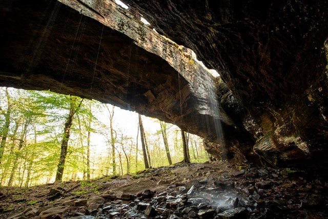
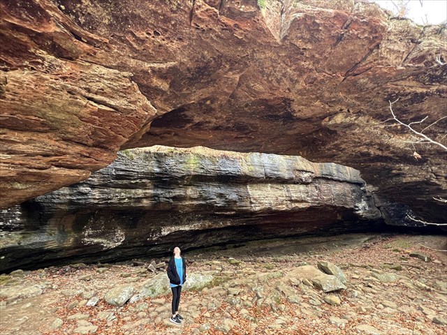
Alum Cove Natural Bridge
One of the most unique geologic features in the Ozark National Forest is the natural stone bridge here at Alum Cove. Formed from the remains of a quartz sandstone cave, over time wind, water and ice weathered the opening between the arch and the rock overhang. The arch itself spans an incredible 130 feet and is 20 feet wide! It's so big, you may not even realize you are standing on it when the trail crosses over the top. 
According to Forest Services, early settlers reportedly used this arch to move their wagons and livestock across the streambed during wet weather. Native Americans even used the overhang as shelter on hunting trips, as well as some of the other caves and formations along the bluff line across the cove.
Natural Bridge Formation
The formation of natural bridges are made by erosion - the process where materials are broken down and transported by natural forces. Natural bridges can also be referred to as rock bridges, rock arches, or natural arches.
The most common way for a natural bridge to form is through water erosion. As a river or stream flows, water erosion breaks down and carries sediments and minerals that are caught in the flow of water and erode the land in its path. This creates the 'supports' of the natural bridge.
Wind erosion also contributes to the formation of natural bridges and arches. Sediments erode the exposed rock as the wind blows. As this pattern continues over time, a hole is created between the two rock supports and creates a natural bridge. Freeze-thaw action (erosion due to ice) is also a contributing factor to the formation of natural arches.
Freeze-thaw action also helps create caverns. As water enters the cracks in the rock and freezes, the rock expands and erodes away material as the ice melts. As the process repeats over time, the inside of the rock becomes hollowed out. Eventually, the walls erode and can cause the cave to collapse.
A natural bridge forms when the roof of a cave collapses but a section of rock remains intact between two points. Another splendid example of a natural bridge formed from a cave collapse is the Natural Bridge in Rockbridge County, Virginia.
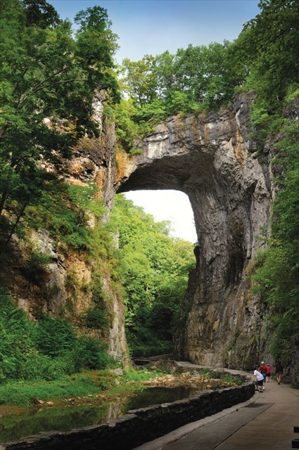
Natural Bridge - Rockbridge County, Virginia
Bridge or Arch?
Bridges and arches are both fragile, natural rock sculptures. Both are formed with water and time, but with different processes. Running water carves natural bridges while seeping moisture and the freeze-thaw cycle shape arches.
To Get Credit For This EarthCache
Copy the questions below and send your answers via geocaching messages.
- DO NOT post the answers in your log.
- Group answers are fine, just let me know who all was there.
- Note: The photo task is a requirement for each account claiming a find. See acceptable EarthCache logging tasks effective June 10th, 2019.
- Please send the answers in a timely manner or it may result in the deletion of your log (no offense intended).
Logging Tasks
1| The name of this EarthCache: Alum C🌎ve Natural Bridge
2| In your log, please provide a photo of yourself with the arch of the natural bridge.
- If you prefer, the photo can be of a personal item here instead. Just make the photo unique to you and your visit. Feel free to have fun with this!
3| Describe the difference between a natural bridge and an arch.
4| In your opinion, do you think the natural bridge will continue to erode at the same rate now that it is separated from the rest of the cave? Explain your thoughts.
*IF YOU ENJOYED THIS EARTHCACHE,
CONSIDER GIVING A FAVORITE POINT!*
Sources: