|
|
 |
FTF: Azulka |
STF: - |
TTF: - |
| |
 Άλλα δημοσιευμένα στάδια του "Corfu Trail"
  Other published stages of the "Corfu Trail"
  Weitere veröffentlichte Etappen des „Corfu Trail“
Το Corfu Trail είναι μια μεγάλη απόσταση με τα πόδια από τον Κάβο στα νότια της Κέρκυρας μέχρι τον Άγιο Σπυρίδωνα στα βόρεια.
Δημιουργήθηκε από τον Hilary Paipeti τον Μάιο του 2001 και έχει μήκος περίπου 220 χιλιόμετρα.
Το τοπίο αλλάζει από αμμώδεις παραλίες και αμμόλοφους στο νότο σε ελαιώνες και βουνά στη μέση και όμορφες παραλίες στα βόρεια.
Τα στάδια έχουν μήκος μεταξύ 10 και 18 χιλιομέτρων και πάντα ξεκινούν ή τελειώνουν εκεί όπου μπορείτε να βρείτε ένα δωμάτιο για τη νύχτα.
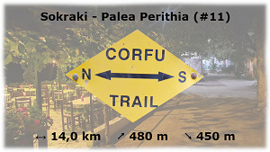
Από το Σωκράκι στην Παλαιά Περίθεια (#11)
Διαμονή (προαιρετικό και δεν απαιτείται για την εύρεση του geocache):
Σωκράκι: Corfu Sokraki Villas
Παλαιά Περίθεια: The Merchant's House
1. εργασία (Διόπτρες):
N39° 42.870 E19° 47.595
A = Μετρήστε τις βίδες της στρογγυλής πλάκας βάσης στο έδαφος
2. εργασία (σημάδι τρόπο):
N39° 43.104 E19° 49.167
Εδώ είναι μια ξύλινη πινακίδα σε ένα δέντρο.
B = Θέση στο αλφάβητο του δεύτερου γράμματος
3. εργασία (αστέρια):
N39° 43.255 E19° 50.308
C = Πόσα αστέρια βλέπετε στην κόκκινη πινακίδα του "Snack Cafe Asteras" ?
4. εργασία (Μαύρος Ανδρας):
N39° 43.613 E19° 50.993
Εδώ είναι ένας μαύρος που τρέχει σε μια πορτοκαλί πινακίδα.
D = Πόσες λέξεις με ελληνικά γράμματα είναι γραμμένες στην πινακίδα; ?
5. εργασία (παρεκκλήσι):
N39° 43.582 E19° 51.027
Πηγαίνετε μέσα και δείτε τη μεγάλη εικόνα στην αριστερή πλευρά.
E = Πόσα άλογα βλέπετε; ?
6. εργασία (Παντοκράτορας):
N39° 44.944 E19° 52.071
Από εδώ κοιτάξτε στον Παντοκράτορα.
F = Μετρήστε τα παράθυρα που βλέπετε στο σπίτι αριστερά δίπλα στον μεγάλο πύργο (Έλεγχος: ίδια ποσότητα μικρά και μεγάλα παράθυρα)
Τελικές συντεταγμένες:
"N39° 45." A*B*C*D*E*F-2225 " E19° 52." A*B*C*D*E*F-2247

The Corfu Trail is a long distance walking route from Kavos in the south of Corfu to Agios Spiridon in the north.
It was created by Hilary Paipeti in May 2001 and is about 220 km long.
The landscape changes from sandy beaches and dunes in the south to olive groves and mountains in the middle and beautiful beaches in the north.
The stages are between 10 and 18 kilometers long and always starts and ends where you can find a room for the night.
From Sokraki to Palea Perithia (#11)
Accommodation (optional and not needed to find the geocache):
Sokraki: Corfu Sokraki Villas
Palea Perithia: The Merchant's House
1. task (Binoculars):
N39° 42.870 E19° 47.595
A = Count the screws of the round base plate on the ground
2. task (Way sign):
N39° 43.104 E19° 49.167
Here's a wooden way sign at a tree.
B = Position in the alphabet of the second letter
3. task (Stars):
N39° 43.255 E19° 50.308
C = How many stars do you see on the red sign of "Snack Cafe Asteras" ?
4. task (Black man):
N39° 43.613 E19° 50.993
Here's a black running man on an orange sign.
D = How many words in greek letters are written on the sign ?
5. task (Chapel):
N39° 43.582 E19° 51.027
Go inside and look at the big picture on the left side.
E = How many horses do you see ?
6. task (Pantokrator):
N39° 44.944 E19° 52.071
Look up to Pantokrator from here.
F = Count the windows you see at the house left beside the big tower (Check: same amount small and big windows)
Final coordinates:
"N39° 45." A*B*C*D*E*F-2225 " E19° 52." A*B*C*D*E*F-2247
Der Corfu Trail ist ein Fernwanderweg von Kavos im Süden von Korfu nach Agios Spiridon im Norden.
Er wurde im Mai 2001 von Hilary Paipeti angelegt und ist etwa 220 km lang.
Die Landschaft wechselt von Sandstränden und Dünen im Süden zu Olivenhainen und Bergen in der Mitte und wunderschönen Stränden im Norden.
Die Etappen sind zwischen 10 und 18 Kilometer lang und beginnen bzw. enden immer dort wo man ein Zimmer für die Nacht finden kann.
Von Sokraki nach Palea Perithia (#11)
Unterkünfte (optional und nicht notwendig um den Geocache zu finden):
Sokraki: Corfu Sokraki Villas
Palea Perithia: The Merchant's House
1. Station (Fernglas):
N39° 42.870 E19° 47.595
A = Zähle die Schrauben an der runden Bodenplatte
2. Station (Way sign):
N39° 43.104 E19° 49.167
Hier befindet sich ein hölzerner Wegweiser an einem Baum.
B = Position im Alphabet des 2. Buchstabens
3. Station (Sterne):
N39° 43.255 E19° 50.308
C = Wie viele Sterne siehst Du auf dem roten Schild "Snack Cafe Asteras" ?
4. Station (Schwarzer Mann):
N39° 43.613 E19° 50.993
Hier befindet sich ein schwarzer rennender Mann auf einem orangenen Schild.
D = Wie viele Wörter in griechischen Buchstaben stehen auf dem Schild geschrieben ?
5. Station (Kapelle):
N39° 43.582 E19° 51.027
Gehe hinein und betrachte das große Bild auf der Linken Seite.
E = Wie viele Pferde siehst Du ?
6. Station (Pantokrator):
N39° 44.944 E19° 52.071
Schaue von hier aus hoch zum Pantokrator.
F = Zähle die Fenster die Du an dem Haus links vom großen Turm siehst. (Überprüfe: Gleiche Anzahl große und kleine Fenster)
Final Koordinaten:
"N39° 45." A*B*C*D*E*F-2225 " E19° 52." A*B*C*D*E*F-2247
Πανό για το προφίλ σας: Banner for your profile: Banner für Dein Profil:
<a href="http://coord.info/GCAE9NC><img src="https://img.geocaching.com:443/0755bcab-9ed2-42d8-9d8c-30e105bf0310.png" width="300" height="169" /></a>