Wheal Remfry Explosion Breccia EarthCache
Wheal Remfry Explosion Breccia
-
Difficulty:
-

-
Terrain:
-

Size:  (other)
Please note Use of geocaching.com services is subject to the terms and conditions
in our disclaimer.
This EarthCache focuses on some boulders of a rock type that has helped geologists to study how igneous rocks interact with existing rocks during their formation and emplacement.
Granite is an intrusive igneous rock. This means that it formed below ground from melted rock called magma. Insulated beneath a thick layer of overlying rock, the magma cooled and solidified relatively slowly compared to being erupted out of a volcano on the surface. This slow cooling provided the time needed for the elements present in the magma to form crystals large enough to be seen by eye, without having to use a microscope. These are known as phaneritic (pronounced FanErRittic) rocks.
Although the entire igneous intrusion found in South West England (and known as the Cornubian Batholith) is connected underground, the granite rocks exposed on the surface are not all exactly the same age. Nor do they display the same geological features. It’s these differences that formed as the magma interacted with the pre-existing rocks above and beside it that are so interesting to geologists.

The granite rocks that form the St Austell (or Hensbarrow) granite are approximately 270-285 million years old. This EarthCache focuses on one of the youngest rocks formed during that time, just 270 million years ago.
Standing at the headline coordinates, you are very close to the contact between the western edge of the St Austell granite and the sedimentary rocks that existed before the granite. We call the earlier rocks that the igneous rocks intruded into the country rock. A local term used in Cornwall for these rocks is killas. The heat and pressure from the intruding granite caused changes to these adjacent country rocks. Geologists would now class them as metasediments as they underwent metamorphism – changes to their mineralogy and textures (relationships between the different crystals or grains that make them) without being completely remelted.
The actual contact between granite and killas is hidden beneath the mountainous waste tip immediately to your east. Also, as the land beyond the tip is a working China Clay pit, it too is sadly inaccessible. However, whilst extracting China Clay from the pit, geologists discovered a fascinating exposure that indicates how the granite and killas interacted 270 million years ago. Even luckier for us, boulders that ‘tell the story’ have been placed at the headline coordinates.
As you approach from the suggested parking spot, the first boulder is fairly typical late-stage granite of the St Austell Granite intrusion. The typical mineralogy of St Austell granite is:
1) Glassy grey crystals of quartz.
2) Milky/pearly white crystals of feldspar.
3) Shiny black or white crystals of mica.
Sometimes, larger than average crystals of feldspar may be present. We call these phenocrysts or megacrysts depending on their size compared to the other crystals in the rock.
Occasionally, there are millimeter-thick veins (called stringers) of black tourmaline (schorl) that cut through the rock. Tourmaline contains (among many others) the element boron. Unlike elements such as sodium or magnesium, the chemical properties of boron make it difficult for it to crystallise into many minerals and so geologists call it an incompatible element. Tourmaline is one of the few minerals it can form in though, so tourmaline is often seen when a large quantity of incompatible boron gets leftover in a magma chamber.
The second and third boulders at the headline coordinates are completely different and show what happened when the rocks above the roof of the magma chamber became fractured, allowing hot boron-rich fluids to stream through them under great pressure over an area of approximately 500m x 100m. This process happened a number of times and gave rise to some very distinctive textures and mineral assemblages that you can be clearly seen in these boulders.
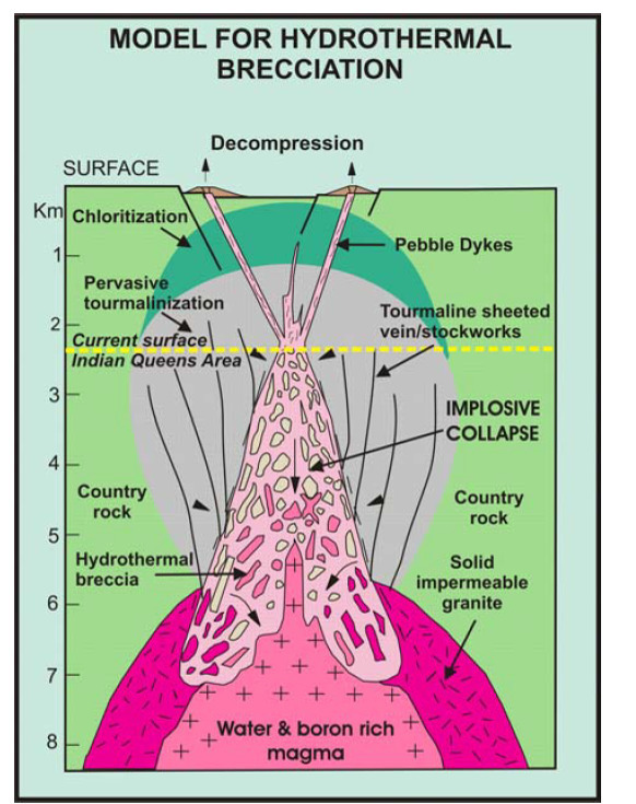
Geologists think that the killas above the magma chamber some 270 million years ago was already fractured by a large geological fault in the Fal Valley Fault Zone. Surface water seeped down through the rocks, became heated and increased in pressure. At this point, the unstable ‘roof’ of rock above the magma chamber couldn’t withstand the pressure so the hot hydrothermal fluids and some very late stage magma exploded towards the surface. Pieces of killas and already formed granite were forcibly plucked from the side walls of the fractured zone that the fluid moved through. On eruption, the pressure decreased and the fluid slumped back down, cooling and crystallising in place. A model to summarise this process is shown below:

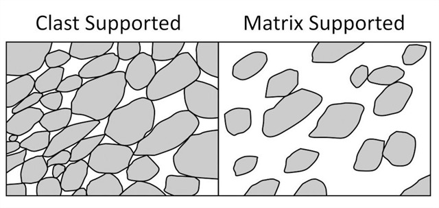
The second and third boulders are examples of the rock that formed during that violent event and are known as the Wheal Remfry explosion breccia. Breccia comes from the Italian word for rubble and there are two different categories of breccia:
Clast supported - where the larger broken pieces (called clasts) touch each other and the matrix material just fills the gaps in between; and
Matrix supported - where the clasts are not in contact and the matrix surrounds each clast.

In order to log this EarthCache, please visit the headline coordinates, observe the boulders indicated and send the answers to the following questions via email or the message centre:
1) Observe the first boulder that you see on the left hand side of the path as approaching the headline coordinates from the suggested parking. Describe the colours and sizes of any crystals that you can see in it. Are there any phenocrysts present? If so, estimate their size and suggest what mineral you think they are.
2) Now observe the third boulder and notice how is it different to the first boulder. Estimate the dimensions of the largest clast that you can see in the boulder and suggest what this indicates about the energy that the hydrothermal fluid stream had. Hint – Smaller pieces would indicate relatively low energy.
3) Would you say that this breccia is clast supported or matrix supported? What colour is the mineral that forms the groundmass (matrix material)? Suggest what mineral you think it might be.
You do not need to wait for my reply to log your find, but please ensure that you send your answers before you log your find. Also, feel free to upload any pictures, so long as they do not constitute a spoiler.
Additional Hints
(Decrypt)
Ybbx ng gur svefg naq guveq obhyqref ba gur yrsg nf lbh nccebnpu TM sebz gur cnexvat pbbeqvangrf