Logging Requirements
1. Please send your answers before logging this earthcache
2. If you are in a group, only one member needs to submit the answers however each person will need to post a photo showing they were on site. A group shot is acceptable.
3.Logs without sending answers will be deleted
Parking is available at the posted coordinates.
Questions:
- Based on the information provided, what is the main factor based on the geology of the area that caused developers to consider building a constructed wetland ?
- What does a natural wetland require to be maintained?
- What Lava Flow Hazard Zone does this location sit in?
- From the information on the plaque at the posted coordinates and from the write up, in your own words describe the purpose of a constructed wetland?
- Based on the information on the cache page, what are two advantages of a constructed wetland? What is one disadvantage of a constructed wetland?
- From the information at the posted coordinates, name three native wetland plants that are being used to capture contaminents as part of the constructed wetland? Can you observe any from this location?
- Observe the wetland at the posted coordinates. Does this wetland have open water or do the native plants fill the entire wetland.
- Optional: Photos showing your or a personal item, with the wetland in the background are appreciated but not required.
Geology of the district of Puna and the town of Pāhoa
According to maps from the US Department of the Interior and USGS, the town of Pāhoa sits in Zone 2 (LHZ2) of the Lava Flow Hazard Zones on the Island of Hawaii. It is also adjacent to Zone 1 and Zone 3.
Zone 1 - Includes summits and rift zones of Kilauea an Mauna Loa, where vents have been repeatedly active in historical time
Zone 2 – Areas adjacent to and downslope of zone 1. Fifteen to twenty five present of zone 2 has been covered by lava since 1800 and 25-75 percent has been covered within the past 750 years. Relative hazard within zone 2 decreases gradually as one moves away from zone 1
Zone 3 – Areas less hazardous than zone 2 because of greater distance fro recently active vents and because of topography. One to five percent of zone 3 has been covered since 1800, and 15 to 75 percent has been covered in the past 760 years.
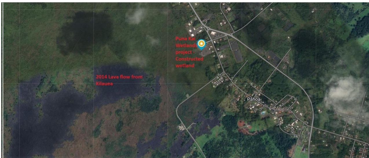
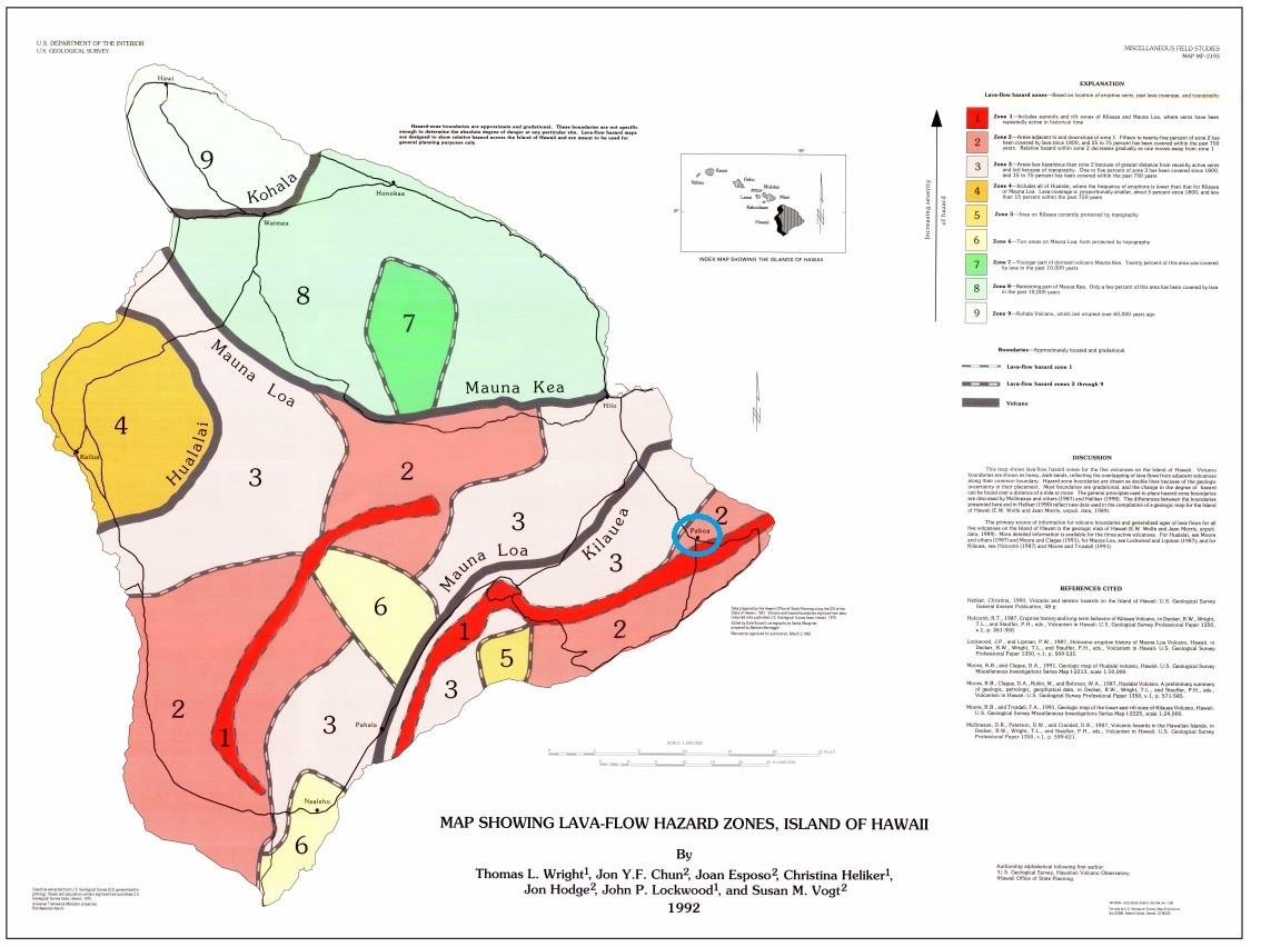 Pāhoa is shown circled in blue on map
Town of Pāhoa
The town of Pāhoa sits on top of hundreds of years of lava flows, most recently the 2014 flow from Kilauea, which stopped just 600ft shy of the main supermarket, and 200 ft from main street.
Because of this geology, and the high risk of future eruptions, it is not possible to dig down to install water and sewer lines for housing and business in many locations as both the ancient and more recent lava flows lie just below the surface of the town. Excavation is very challenging due to eruptions and earthquakes. As a result, a recent development in the area to bring back some economy to the town had to look at wetlands as a way to filter wastewater before sending it back to the groundwater system.
Natural Wetlands
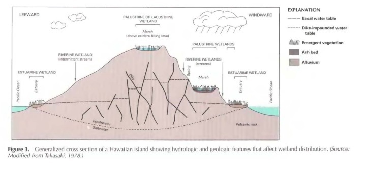
Natural Wetlands in Hawaii constitute less than 3 percent of the State but provide a vital role in protecting waterfowl and shorebird habitat and improving water quality and reduce flooding. Typically, Hawaiian wetlands are found at or near the water table, close to shorelines, along river systems or where land is covered by shallow water.
While natural wetlands can be found across the Hawaiian Islands at any elevation, they do require a water source to maintain the wetland so are largely determined by climate and topography. For example, moisture-laden air masses move with the trade winds and move up the sides of volcanic mountains, releasing their moisture as they cool at higher altitudes. Also rainfall is more plentiful on the windward side of the Islands so wetlands are more sustainable when there is a constant source of water.
Wetlands are also recognized to be increasingly important for wastewater treatment due to the ability of the wetland plants to absorb large amounts of nutrient and toxic substances.
Constructed Wetlands
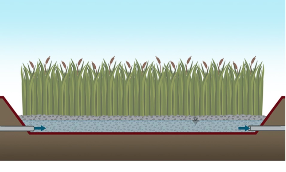
Constructed wetlands (CWs) are engineered wetlands deliberately designed to replicate the physical, chemical, and biological processes occurring in natural wetlands for wastewater treatment purposes.
Advantages
- When properly built and maintained, a constructed wetland can remove many pollutants associated with municipal and industrial wastewater and stormwater, including suspended solids, nitrogen, phosphorus, hydrocarbons and even metals
- Include water loving plants that help filter stormwater before slowly releasing the water downstream.
- Is a natural process
Disadvantages
- May require a large land area compared to a conventional facility
- May not be able to handle highly hazardous effluent ( toxic waste) that needs to be processed in a specialized facility
- Danger of wetland becoming a swamp that acts as a breeding ground for mosquitoes and other diseases
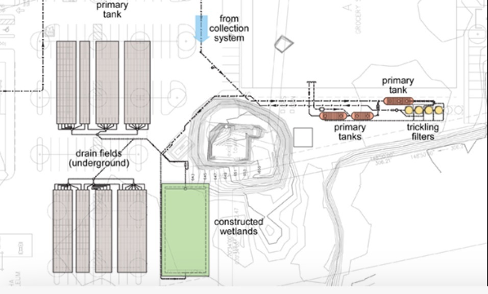
Puna Kai shopping center is a new 100,000 sq ft retail/commercial facility in the District of Puna on the Big Island of Hawaii that features a local grocery store and restaurants on 10 acres, including ½ acre of new parkland.
When constructed, the shopping centre did not have access to sanitary sewers and therefore, all waste water from the facility and parking lot would need to be captured and treated onsite. This wastewater would also need to be discharged back into the groundwater onsite as well.
The owners of the facility looked at natural systems as a way of managing the water, and consulted with engineering groups that had designed similar systems including three fishponds located at Honolulu International Airport and a constructed wetland at the University of Hawaii West Hawaii Campus ( Kailua-Kona), a project that received LEED Platinum status.
The facility at Puna Kai Shopping Centre includes a 16,000 gallons per day, constructed wetland wastewater treatment system. The treatment system consists of both primary treatment, trickling filters and constructed wetlands that produce clean water and serve to make the shopping centre sustainable on its own.
References:
https://www.rothecological.com/ecoengineer-projects
https://www.biohabitats.com/project/puna-kai-shopping-center-onsite-wastewater-treatment/
https://www.fws.gov/wetlands/data/Water-Summary-Reports/National-Water-Summary-Wetland-Resources-Hawaii.pdf
https://pubs.usgs.gov/mf/1992/2193/mf2193.pdf
https://www.civilbeat.org/2021/05/rebuilding-in-puna-ma-kai-is-folly/
Global Volcanism Program | Report on Kilauea (United States) — December 2014 (si.edu)