Welcome to Cache Across Maryland 2024. This is one of ten caches placed for the 2024 Cache Across Maryland. Each location was picked specifically to give geocachers a taste of the state and show you its beauty. By combining all ten, you'll be able to see why Maryland is truly "America in Miniature". We hope you enjoy them! You must find a minimum of ten caches prior to the picnic held on Saturday, May 11, 2024 in order to receive a free Maryland Geocaching Society CAM geocoin.
Make note of the code word found inside each cache container. You must enter all the words into an online decoder in order to print a claim form to print and submit to receive your geocoin at the picnic, as well as your CAM certificate. More info on CAM is available HERE.
Jug Bay Wetlands Sanctuary
***NO PETS
Admission Fee
- $6.00 per vehicle fee (Payable in the Visitors Center)
- Free for active military, veterans, and their families
Operating Hours
- Monday, Tuesday, Thursday - CLOSED
- Wednesday, Friday, Saturday - 9AM to 5PM
- Sunday - 9AM to 5PM (March to November)
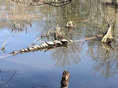
The Jug Bay Wetlands Sanctuary is located along the tidal Patuxent River in southern Anne Arundel County in Maryland. It was established in 1985 and is operated by the Anne Arundel County Department of Recreation and Parks. It includes more than 1,700 acres of tidal freshwater marshes, forested wetlands, upland and riparian forest, creeks, meadows, pine and sand barrens and fields along the Patuxent River. This protected land providews a safe haven for a high diversity of plants, insects, mammals, amphibians, reptiles, birds, fish and microbes, and to rich Native American cultural resourses. Archaeologists have uncovered evidence of a large Native American settlement at Jug Bay which spanned 2 miles along the Patuxent, with the oldest arrowhead-like artifact dated between 8,000 and 8,900 years old.

In 1990, the Sanctuary became a component of the Chesapeake Bay National Estuarine Research Reserve System. The sanctuary was recognized as a Nationally Important Bird Area in 2016 by the American Bird Conservancy and the National Audobon Society. Jug Bay is located with the Atlantic Flyway and is haven for more than 100 species of birds, including native and migratory waterfowl, songbirds, and raptors.
With over 80 identified archaeological sites of interest, Jug Bay is a research hotspot showcasing the continuity of human habitation from 11,000 years ago to the present day.
The goals of the sanctuary are to provide environmental education opportunities to the public, to conduct ecological research, and to conserve Jug Bay's unique ecosystem. Several hundred volunteers act as docents and guides to the public and assist with long-term ecological studies.
The posted coordinates are for parking. Take a walk on the flat trail which consists of mostly dirt, leaves and a little graval to visit six waypoints to gather the information required to get the final coordinates. You will be required to scan a QR code to listen to a message at each waypoint. You are searching for N38 46.ABC W076 42.DEF
Waypoint 1 - Jug Bay History (N38 47.085 W076 42.120)
The objects shown at the bottom of the sign depict tools left behind by semi-_________, native American tribes as far back as 10,000 years ago
A =Number of letters in the missing word
Waypoint 2 - Spice Bush (N38 46.972 W076 42.131)
__________ called this plant "fever bush" because a strong tea made from the bark brings on a sweat, activating the immune system and expelling toxins.
B = Number of letters in the missing word
Waypoint 3 - Native Ground Cover (N38 46.807 W076 42.257)
The forest floor is composed of leaf ________, fallen trees and ground cover.
C = Number of letters in the missing word
Waypoint 4 - What Do You See? (N38 46.743 W076 42.248)
According to the narrator, this stretch of river is protected on both sides by: (choose the correct answer)
- 3 = National Wildlife Refuge Land
- 2 = Department of Natural Resources Land
- 1 = County Park Land
- 0 = The Patuxent Riverkeeper
D = the number next to the correct answer
Waypoint 5 - Creek Meets the River (N38 46.694 W076 42.174)
The Patuxent River continues _____ miles south of here to connect to the Chesapeake Bay
E = Second digit in the missing number
Waypoint 6 - Beaver Pond (N38 46.761 W076 42.150)
They provide storage for _________, which is gradually released through dry periods.
F = Number of letters in the missing words (two word answer)
N38 46.ABC W076 42.DEF
The cache you seek is an otter box. It is hidden under a log and may be a little sneaky for some. Use stealth when retrieving and replacing cache. Due to its proximity to the trail, please hide as well as or better than found.
Trail map can be found HERE.
If you find that any of the QR codes are missing or inaccessible, the Yellow Loop Self-Guided Tour information can be found HERE.