
Nestled along the Atlantic Coast, Virginia Beach is distinguished by its expansive and immaculate shorelines. Renowned for its pristine beaches, characterized by sunlit sands and the rhythmic sounds of the ocean, the city offers an unparalleled coastal retreat. The vibrant boardwalk, complemented by a range of oceanfront activities, contributes to the city's reputation as a premier beach destination.
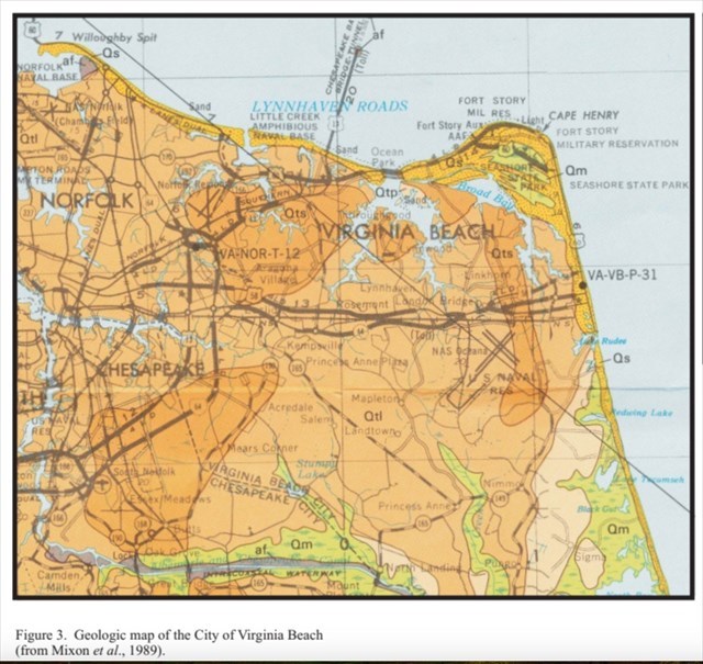
The geologic units near Virginia Beach exhibit diverse characteristics, providing insight into the region's dynamic geological history. Above is a geologic map of the Virginia Beach area. It is color coded based on geologic unit. There are five main geologic units underlying this area. Holocene Sand (Qs) is poorly to well sorted (more on sorting later), is shelly in part and contains pieces of mollusks. It composes the coastal barrier islands and beach dune ridges near marshes. This geologic layer is roughly 40 feet thick. Next, there is Holocene Soft Mud (Qm), which is medium to dark gray color and contains peat. It composes the sediments of marshes in coastal areas and is 0-10 feet thick. Then there is the Poquoson Member (Qtp), which is composed of medium to coarse pebbly sand and a light to medium gray color. It underlies the ridge and swale topography (basically a set of regular parallel ridges with a marshy depression in-between) along the edge of the Chesapeake Bay and lower part of the Coastal plains rivers. This member is 0-15 feet thick. The next geologic formation is the Lynnhaven Member (Qtl), which is mostly composed of pebbles and includes sand, clays, and silts. It is usually a surface deposit and 0-20 feet thick. Lastly there is the Sedgefield Member (Qts), which is pebbly to bouldery and also contains sands and silts. It is also a surface deposit 0-50 feet thick.
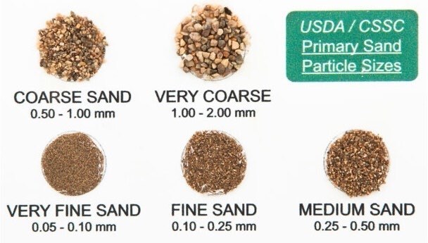
The Wentworth scale, developed by Chester K. Wentworth in 1922, is a granulometric classification system used to categorize sediment particles based on their size. Specifically applied to the classification of sand, this scale distinguishes various grades of granularity, ranging from very fine to very coarse. The classification is based on the diameter of individual sand grains, with fine sands (0.0625 - 0.125 mm), medium sands (0.125 - 0.25 mm), coarse sands (0.25 - 0.5 mm), very coarse sands (0.5 - 1.0 mm), and extremely coarse sands (>1.0 mm). This standardized approach facilitates a systematic understanding of sediment characteristics, aiding geologists, engineers, and researchers in analyzing and categorizing sand samples for geological and engineering purposes. The Wentworth scale serves as a valuable tool in both scientific and practical contexts, offering a structured framework for classifying sand particles according to their size.
Another topic worth mentioning is sorting, which refers to the uniformity or homogeneity of sediment particle sizes within a deposit. Well sorted sediments exhibit a consistent range of particle sizes, while poorly sorted sediments encompass a broader spectrum of sizes, ranging from fine to coarse. Sorting is a crucial characteristic in the study of sedimentary environments as it reflects the processes of transportation, deposition, and the energy conditions within a particular geological setting. When applied to beach sand, sorting provides valuable insights into the dynamics of coastal processes. Well sorted beach sands typically indicate a consistent and efficient sorting mechanism, often associated with the sorting action of waves. Coastal environments with strong wave action tend to produce well sorted sands, as the rhythmic back-and-forth movement of waves selectively transports and deposits sediment particles based on their size and weight. On the other hand, poorly sorted beach sands may suggest less consistent wave action or the influence of additional factors such as river input, where a variety of sediment sizes are transported and deposited with less discrimination. The proximity of bays can also have an effect on the sand. Acting as natural wave buffers, bays reduce wave energy, leading to the deposition of finer sediments along the bay entrance. This altered energy regime influences the composition and texture of beach sands, with the reduced wave energy allowing for the settling of finer particles. In addition, tidal currents associated with bays contribute to sediment transport, affecting the distribution and sorting of beach sediments.
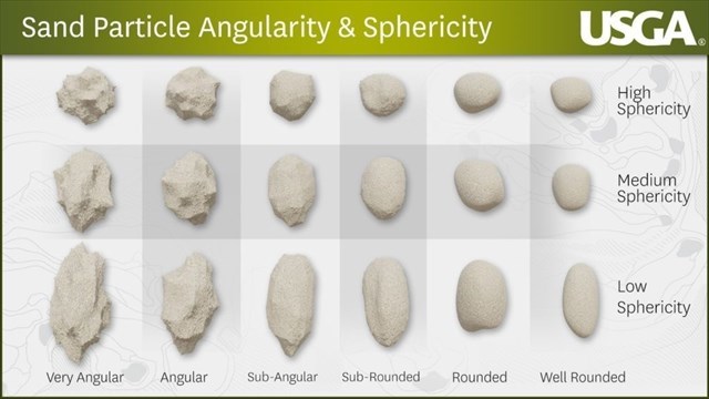
The sphericity and angularity of the sand particles can tell us a lot of information. Sphericity, a measure of how closely sand grains approach a spherical form, serves as a tangible indicator of the degree of abrasion and rounding experienced during transportation. Grains exhibiting high sphericity are typically well-rounded and smooth, suggesting prolonged transport in dynamic, high-energy environments such as river channels or coastal zones where the abrasive effects of water or wind play a significant role in shaping the sediment. Grains with low sphericity indicate that they have retained a more angular or irregular shape, suggesting limited abrasion and rounding during transportation. This often points to a shorter transport distance and a depositional environment with lower energy levels. In geological terms, low sphericity in sand grains may imply that the sediment source was relatively close, and the grains experienced minimal wear and tear as they were deposited. Conversely, angularity focuses on the sharpness of edges and corners of individual sand grains, providing valuable insights into the degree of mechanical weathering and the proximity of the sediment source. Highly angular grains retain their original, sharp features, indicating minimal transport and limited exposure to erosive forces.
Logging Requirements:
- The beach you are standing on is composed of Holocene Sand (Qs). Why do you think Holocene Sand is only found along the coastline, and not further inland (hint: think about how it might have been deposited)?
- Next, examine the sand closely and describe what you see. How would you describe the sorting at this location?
- Cape Henry, which marks the entrance to Chesapeake Bay is located a few miles north of here. How do you think traveling further south, away from the entrance to the Chesapeake Bay affects sorting?
- Using the image on the cache page as a guide, how would you classify the size? What about the angularity and sphericity of the sand particles?
- Based on what you have learned, do you think the close proximity to the entrance of Chesapeake Bay affects the physical characteristics of the sand found on the beach? Why or why not?
- Upload a photo taken near the posted coordinates. You don't have to be in the photo, though it is strongly encouraged.