To
log this earthcache, send me an email with the answer
to the following questions:
1. What type of rocks form
the environment of the breccia? To what formation do
they belong? In what period were these rocks formed?
2. These rocks are hard or soft. What was the
geological origin of the gap? (why was it formed
here?)
3. Describe the rock that forms the wall of
the Gap at a height of one meter, (Color, texture,
brightness or not, etc.)
4. Add a photograph of you in the
premises, or another in which you can see an object,
or your nick on a piece of paper
If you believe you have
successfully completed this Earth Cache goals and
has already sent to me all the requirements as
requested, Please, feel free to log it as found.
Later i will verify the requirements sent and, if
necessary, contact you in order to make the
necessary corrections to your log.
|
|
Location
The Roland Gap (brèche de Roland in French) is a narrow
pass 40 meters wide and 100 meters high, located at an altitude of
2804 meters in the Monte Perdido massif. According to local
legend, it was opened by Roland, Charlemagne's nephew, while
trying to destroy his sword Durandal by striking it against the
rock at the end of the Battle of Roncesvalles. In reality, it is a
beautiful excursion in the High Pyrenees accessible from France
(Gavarnie) and from Spain through the Ordesa and Monte Perdido
national park (Ordesa valley), either through the Góriz refuge or
ascending the Carriata cirque or by Cotatuero
Origin
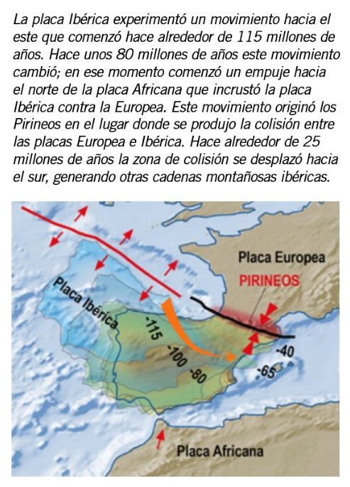
Although today the Pyrenees constitute a large mountain range of
the Iberian Peninsula and a geographical barrier that separates
Spain from France, its origin is -geologically speaking-
relatively "recent". The place occupied today by the mountains
constituted a sea until about 35 million years ago. Testimony of
this process are the fossil remains of organisms that lived on the
seabed and that today we find in the rocks that constitute the
highest peaks of the National Park, such as Monte Perdido, at more
than 3,300 meters above sea level. . The formation process of the
mountain range took place over 250 million years. During the first
part of this period, sediments accumulated in a marine basin that
was later uplifted to form the Pyrenean mountain range.
In other parts of the Park, below the rocks that form the walls of
these three valleys, there are older rocks, such as in the La
Larri valley, where under the Upper Cretaceous strata we find
red-colored sandstones deposited during the Permian and Triassic
periods. , and below it intensely folded stratified rocks
deposited during the Paleozoic era. Thus, we can take a tour of
the different episodes in the history of the Earth in this sector
of the Pyrenees, paying close attention to the rocks of the
National Park.
In the entire northern band of the geological map, already outside
the limits of the National Park, we find outcrops of intensely
folded rocks. These are rocks much older than the strata of the
Ordesa and Añisclo valleys. They were deposited between 470 and
350 million years ago in the Paleozoic era and were deformed when
a large mountain range was formed: the Variscan Chain during the
Carboniferous period. This chain suffered great erosion and was
completely destroyed before the formation of the Pyrenees. The
fact that today we find these rocks on the surface forming the
core of the Pyrenees is due to their uplift during the Alpine
orogeny.
200 million years ago the great Variscan mountain range was
rapidly eroding. At that time in the area of ??the Pyrenees there
were extensive alluvial and fluvial areas where red colored
sediments were deposited.
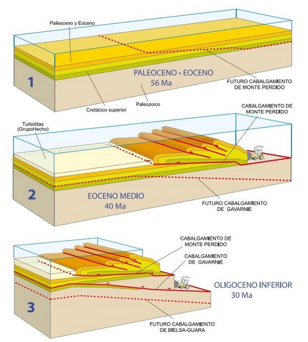
1. Initial state at the end of the Paleocene.
2. In the middle Eocene, the small tectonic units (flakes) that
make up the U. of Monte Perdido had already been emplaced, and now
the entire U. of Monte Perdido is moving on its lower thrust,
which cuts the strata upwards.
3. During the lower Oligocene, the Gavarnie unit moves: the Monte
Perdido Unit is already immobile and below it, the tectonic
compression causes the rupture and creation of a new thrust, which
already cuts the units of the Paleozoic base. The latter is the
Gavarnie Thrust, which in its movement carries on its back the U.
de Mte. Lost that folds as a result of bulging
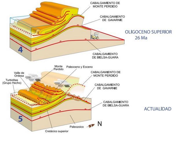
4. In this episode, a new deeper thrust is formed below all the
previous ones, the Bielsa-Guara Thrust, which carries the previous
ones on itself. As with the C. de Gavarnie, its displacement
causes the overturning of all the units previously placed to the
south.
5. Current situation: the intense erosion of the Pyrenees has
exposed the tectonic structure: in the deep Gavarnie valley, the
thrust that receives its name has come to light and surrounds the
entire valley, constituting a so-called "tectonic window".
The Monte Perdido massif is a large rocky building constituted by
the stacking of many units of rocks repeated one on top of the
other until constituting this great mass. The different pieces
that compose it -tectonic units-, are
emplaced over 80 million years. However, contrary to what it may
seem, it is the units that are highest in the building that are
placed first. In this way they were progressively pushed up and
deformed by those that were later placed under them by raising
them to their current position
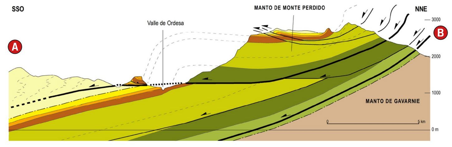
Geological sections
through the National Park showing the structural units. The peaks
of Monte Perdido and Mondarruego correspond to the mantle of Monte
Perdido, made up of several minor thrusts.
Roland's Gap
The
Rolando Gap is, without a doubt, one of the icons of the
National Park. It is a very frequented place due to its scenic
value and because it serves to connect the Spanish and French
sides.
Located at just over
2,800 meters above sea level, it is a deep notch about one
hundred meters high that interrupts the border escarpment
between Spain and France, formed in this section by limestone
from the lower part of the Gallinera Formation (T1).
These rocks are very
resistant to erosion and that is why they form a ridge;
However, in the place of the Gap, a series of fractures made
it weaker, leading to the formation of this mountain pass; The
remains of these landslides are the large blocks that cover
the slope.
Several interesting
geological observations can be made in the vicinity of the
Gap.
On the one hand, the
Taillón and Brecha glaciers and the numerous moraines located
at the foot of the escarpment stand out. On the other hand,
looking towards the Casco (east direction), several thrusts
can be observed that reveal the complex tectonic structure of
the sector (fig. 15).
In fact, from the
previous stop to this one, several thrust planes are cut,
often revealed by the repetition of the reddish Marboré
sandstones.
Fuentes:
Guia geologica de Ordesa y Monte Perdido
|
|