In the lead-up to the Civil War, Lecompton was pivotal in heightening the dispute over slavery and the battle for Kansas' statehood. The territorial legislature named Lecompton the capital of Kansas Territory in 1855. A majority of the populace supported the idea of a Kansas without slavery.
The town quickly became a bastion of Southern support due to election interference by pro-slavery raiders from Missouri. The resulting tensions between free-state advocates and pro-slavery groups led to frequent and violent confrontations with the nearby town of Lawrence, established by Free Staters from Massachusetts. This era of conflict is known as "Bleeding Kansas."
The Lecompton Constitution, drafted in 1857 by Southern advocates of slavery, included clauses to protect slaveholding and a bill of rights that excluded free blacks, contributing to tensions that led to the U.S. Civil War. Rejected in a territorial election in January 1858, it was later supported by President James Buchanan for Kansas' statehood. Congress resisted, proposing a compromise for a second vote by Kansas' residents. The constitution was rejected again in August, and Kansas was admitted as a free state on January 29, 1861, with Topeka officially chosen as the state capital.
Less than three months later, the American Civil War erupted. Consequently, Lecompton's history is closely linked with the conflict over slavery and the series of events that led to the American Civil War.
In order to log this cache, you must:
1. Visit each of the five stages of this virtual geocache;
2. Answer the question associated with each location;
3. Submit all five answers to me via the Message feature or email; and
4. Post an unmistakable photo of yourself at one of the locations. If you would prefer not to show your face, a written sign/note with your caching name(s) and the date clearly visible is acceptable. No photo-editing allowed! Questions are below.
Location 1: Democratic Party Headquarters N 39° 02.911 W 095° 23.478

This limestone building was the headquarters of the pro-slavery Democratic Party from 1854-1861. Determined and powerful individuals convened here to deliberate on issues, devise strategies, and make pivotal decisions that would influence the course of Kansas politics and governance. In later years, the building's purpose shifted from political to commercial activities after being purchased by the Atchison, Topeka and Santa Fe Railroad, which utilized it as a pay station for many years. Pat and Aurelia Istas acquired the property in 1997 and initiated the restoration of the building and its surroundings. The following year, the Lecompton Historical Society took ownership of the site.
Location 2: Constitution Hall N 39° 02.720 W 095° 23.673

Constitution Hall is the location where pro-slavery and Free State proponents held frequent, vigorous debates, which often led to violence. Built in 1856, it is considered the oldest wood building in Kansas. During 1857, it was one of the busiest and most important buildings in the Kansas Territory. Thousands of settlers and speculators filed claims in the United States land office on the first floor. Upstairs, the ill-fated Lecompton Constitution was drafted. Constitution Hall now is home to an outstanding museum, which is open Wed through Sat, 9:00 am to 5:00 pm and Sun 1:00 pm to 5:00 pm. A small donation is requested for admittance.
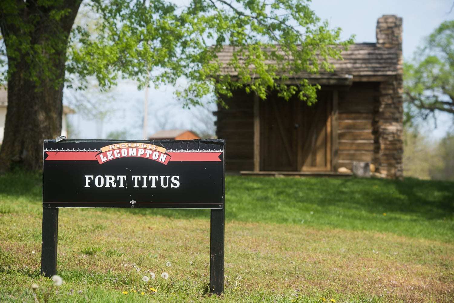
Location 3: Fort Titus N 39° 02.657 W 095° 23.506 On August 15, 1856, the advance guard of the Free State forces reached a cabin six miles west of Lawrence, fortified by "Squatter's Court" Judge John Wakefield. They were met with gunfire from a pro-slavery faction commanded by Colonel Henry Titus. The Free State troops fired back, forcing Titus's group to retreat and resulting in one casualty among his men.
Colonel Titus's cabin, located within two miles of Lecompton, was also fortified against attacks. At dawn the following day, Free State cavalry charged several tents near the cabin, and the pro-slavery forces inside ran toward the structure, chased by the cavalry. Getting too close, they were fired upon from inside, critically injuring four. A cannon was then positioned and deliberately aimed at the cabin. After seven shots, Colonel Titus hoisted a white flag and surrendered. The Free State forces then set the cabin ablaze. The cabin and these grounds represent a reproduction of Colonel Titus's original cabin and the battleground.
Location 4: Post Office Mural N 39° 02.638 W 095° 23.619 A mural of 19th century downtown Lecompton is in the lobby of the post office, which is always open. Ellen Duncan, Lecompton artist in residence, created this mural using old photographs taken of the east side of Elmore Street before a massive fire swept through the downtown area in 1916, destroying several historical buildings on both sides of the street.

Location 5: N 39° 02.691 W 095° 23.514 Lane University/Territorial Capital Museum Lane University was established on the unfinished foundation of the Kansas territorial state capitol building. When Kansas attained statehood, the stone building became the site where President Eisenhower's parents met and were wed. The museum, which opened in 1982, documents Lecompton's history from its contentious territorial era to its charmingly picturesque present. It is recognized on the National Register of Historic Places. The museum is open Wednesday to Saturday, 11:00 am - 4:00 pm, and Sunday, 1:00 pm - 5:00 pm. Donations are welcomed for admittance, with a suggested minimum of $3 per person.

Completion of EACH of the following tasks is required in order to log this virtual cache. Send answers to me either by email or message. Failure to do so will require deletion of your log.
1. Walk up on the porch of the Democratic Headquarters and peer into the window. How many oil lamps do you see?
2. Take the sidewalk to the back of Constitution Hall. How many windows do you see?
3. Review the Fort Titus informational sign. What is the name of the cannon used in the assault of Ft. Titus (not the Abbott Howitzer)?
4. Look closely at the post office mural. What is the last name of the doctor who had an office downtown?
5. Look up at the curved limestone blocks above the main entrance to the Territorial Capital Museum. What words, if any, are engraved on the limestone blocks?
6. Post a photo of yourself (or a personal item, geocaching name on a piece of paper, etc.) with one of the above locations of your choice in the background.
There is also an Adventure Lab in town with a bonus cache.
Virtual Rewards 4.0 - 2024-2025
This Virtual Cache is part of a limited release of Virtuals created between January 17, 2024 and January 17, 2025. Only 4,000 cache owners were given the opportunity to hide a Virtual Cache. Learn more about Virtual Rewards 4.0 on the Geocaching Blog.