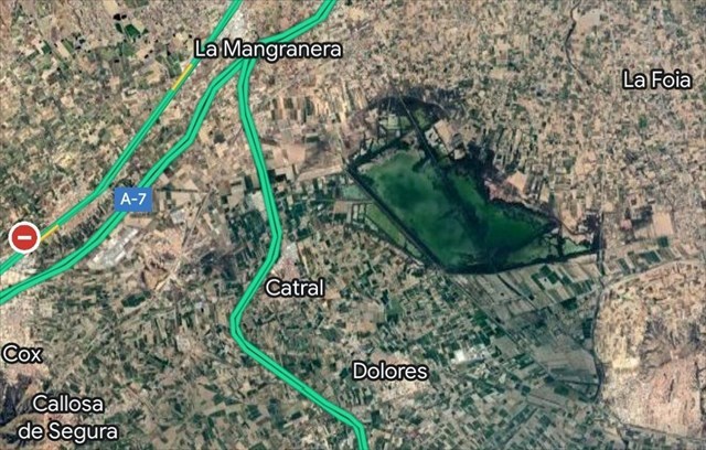
PARQUE NATURAL DE “EL HONDO”
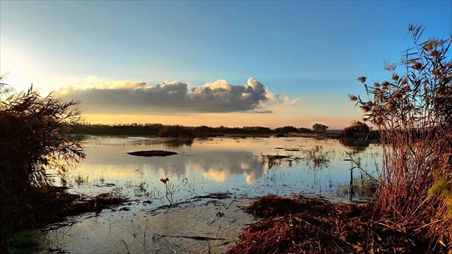
El parque natural de El Hondo (en valenciano parc natural de El Fondo) es un espacio natural protegido
español situado entre los municipios de Crevillente y Elche, en la comarca del
Bajo Vinalopó y Catral y Dolores en la comarca de la Vega Baja del Segura.
El río Vinalopó desemboca en el azarbe de Cebadas, Sivaes o Niño, con quien se encuentra transversalmente al
este del embalse de Levante de El Hondo. Dicho canal tiene dos desembocaduras,
una en las lagunas de este parque, y otra en el mar, atravesando las Salinas de
Santa Pola y dejando al río Vinalopó sin su desembocadura original.1
Las aguas de los embalses de El Hondo (embalse de Levante y
Poniente) proceden principalmente de la desecación en 1803 de la laguna de
Villena (> 717 ha) a través de la acequia del rey, ejecutada por Carlos IV
para procurarse diezmos en beneficio de su renta, y de la desembocadura del río
Segura, siendo elevadas desde el molino harinero de San Antonio, en Guardamar
del Segura, y descendidas por gravedad mediante los aportes fluviales desde la
cuenca endorreica de la Laguna de Villena a través de la acequia del rey como
afluente del río Vinalopó, para abastecer a los regantes de la Comunidad
General de Regantes Riegos de Levante Izquierda del Segura, que es la
propietaria de los mismos.
El Hondo está incluido en el convenio internacional Ramsar de
protección de zonas húmedas y en la directiva europea Zona de Especial
Protección de las Aves (ZEPA). Protege 2387 hectáreas y fue declarado parque
natural por la Generalidad Valenciana el 12 de diciembre de 1988.

GEOGRAFIA
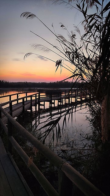 Este parque natural está formado por múltiples lagunas, de
las cuales las dos mayores son la de Levante, de 450 hectáreas, y la de
Poniente, de 650 hectáreas, que se alimentan de las aguas del río Segura y de
los aportes fluviales encauzados por la acequia del rey al río Vinalopó,
provenientes de la gran laguna de Villena, de más de 717 ha, la cual fue
desecada por la ciudad de Elche.
Este parque natural está formado por múltiples lagunas, de
las cuales las dos mayores son la de Levante, de 450 hectáreas, y la de
Poniente, de 650 hectáreas, que se alimentan de las aguas del río Segura y de
los aportes fluviales encauzados por la acequia del rey al río Vinalopó,
provenientes de la gran laguna de Villena, de más de 717 ha, la cual fue
desecada por la ciudad de Elche.
El parque natural de El Hondo, junto con el de las Salinas de
Santa Pola y su entorno, formaba parte de la cuenca hidrográfica del Bajo
Vinalopó, que fue colmatada en el siglo XVII debido a las aportaciones
naturales y los aterramientos del pueblo de Crevillente para obtener nuevas
tierras de cultivo.
El Hondo presenta un clima mediterráneo con características
semiáridas propias del sureste de la península ibérica.
FLORA
Aunque el entorno del parque natural es bastante homogéneo,
es posible diferenciar dos tipos de ambientes en función de la profundidad y
salinidad de las aguas. En los embalses, debido al agua relativamente dulce y
con alto grado de eutrofia, apenas existe vegetación sumergida, destacando el
carrizo y el junco en las aguas poco profundas. En las charcas periféricas, por
término medio más saladas y con aguas de mejor calidad que los embalses, se
presentan diversas especies típicas del saladar endémicas del sureste
peninsular como son el limónium, la suadea o la salicornia.


FAUNA
En las lagunas existen muy variadas especies animales como
son la anguila, el mújol, el camarón de agua dulce y sobre todo el fartet, pez endémico de la región mediterránea española.


Pero sin lugar a dudas, el parque destaca por su avifauna. De
las múltiples especies existentes destacan la cerceta pardilla y la malvasía
cabeciblanca con dos de las principales poblaciones mundiales. Existe una gran
abundancia de garzas en la época de cría destacando entre todas
la garza imperial, el martinete y la garcilla cangrejera.


También es posible encontrar otras especies como la avoceta,
la cigüeñuela, la canastera, la focha moruna, el pájaro moscón o el carricerín
real. Entre las rapaces destacan el águila pescadora, el aguilucho lagunero y
el águila moteada.2 Además, cabe destacar la reaparición de la nutria aun en proceso de recuperación. Toda esta fauna perteneció
al gran entorno lagunar de Villena, tal y como dejó escrito en su "Libro
de la Caza" el príncipe don Juan Manuel de Villena en los siglos XIII-XIV,
la cual se vio obligada a emigrar de sus tierras de origen hasta Elche, tras la
desecación de la gran laguna Villenense.


ACERCA DE ESTE CACHE
Se trata de un Virtual Cache, por lo
que NO EXISTE CONTENEDOR FÍSICO que encontrar. No obstante
si te pido que cumplas los siguientes
REQUISITOS PARA PODER FIRMAR COMO
ENCONTRADO ESTE CACHÉ
1-
En el lugar que se indica en el WAYPOINT 1 encontramos un monolito conmemorativo de la cesión de terrenos por parte del Ayuntamiento de crevillente para la construcción del centro de Interpretación del Parque natural. Debes escribirme un correo electrónico indicando el AÑO EN QUE SE CEDIERON ESOS TERRENOS, QUE APARECE EN UNA PLACA EN LA BASE DEL MONOLITO.
2-
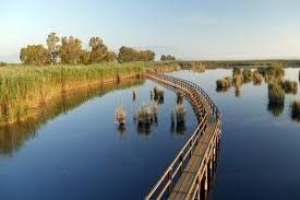
INCLUIR EN EL LOG UNA FOTOGRAFIA REALIZADA EN EL MIRADOR DE “EL CODO”,
que se corresponde con las COORDENADAS PUBLICADAS, y donde aparezca algún ELEMENTO
QUE PERMITA IDENTIFICARTE, (tal como un papel con tu nombre, una geocoin, travelbug o pathtag que te identifique).
IMPORTANTE: me reservo el derecho de ELIMINAR
SIN MAYOR AVISO LOS LOGS QUE NO REUNAN AMBAS CONDICIONES.
ESPERO QUE DISFRUTEIS DE ESTE
MAGNIFICO PARQUE NATURAL Y DE LA SERIE QUE EN ÉL SE HALLA!!!!

“EL HONDO” NATURAL PARK

The El Hondo Natural Park (Valencian: Parc Natural del
Fondo, Spanish: Parque Natural de El Hondo) is located within
the municipal boundaries of Elche and Crevillent both of which are within
the comarca (district) of Baix Vinalopó in the south of the
Valencian Community in the east of
Spain. Both the rivers Vinalopó and Segura discharge into the lagoons that
form this park.
The Vinalopó River
flows into the Cebadas, Sivaes or Niño rivers, with which it
meets transversally to the east
of the Levante reservoir of El Hondo. This canal has two outlets, one in the lagoons
of this park,
and another in the sea, crossing the Salinas de Santa
Pola and leaving the
Vinalopó river without its original outlet.1
The waters of the El Hondo reservoirs (Levante and Poniente reservoirs)
come mainly from the draining in 1803 of the Villena lagoon (> 717 ha) through the King's irrigation
ditch, carried out by Charles IV to obtain tithes
for his income,
and from the mouth of the
Segura river, being raised from the
flour mill of San Antonio, in Guardamar del Segura, and descended by gravity through
the river contributions from the endorheic basin
of the Villena Lagoon through the King's irrigation
ditch as a tributary of the Vinalopó river, to supply
the irrigators of the Comunidad General de Irgentes Riegos de Levante Izquierda del Segura, which is the
owner. of the same.
The park is included in the Ramsar convention list of protected
wetlands and as a Special Protection Area under the European
Union Directive on the Conservation of Wild Birds. It has an area
of 2,495 hectares and was declared a Natural Park by the Valencian
government (Generalitat Valenciana) on 12 December 1988.
TOPOGRAPHY AND CLIMATE
This natural park
is formed by a number of
lagoons, of which the two
largest are manmade and are
called Levante, which has a
surface area of 450 hectares and Poniente, with an area
of 650 hectares. These two lagoons
are fed by the waters of
the river Segura. El Fondo
and the Salinas of Santa
Pola as well as the surrounding area formed part of
the Albufera of Elche known to the
Romans as "Senus Illicitanus". The area of the
park was infilled in the 17th century due to
natural sedimentation and the
placing of silt in order to
create new areas for cultivation. At the same time the
two largest lagoons were damned
to supply water for irrigation.
The natural park
has a semi-arid Mediterranean
climate due to its location
in the south east of the
Iberian Peninsula.
FLORA
Although the parks habitats are fairly homogeneous it is possible
to distinguish two different types
of environment relating to the
depth and salinity of the water.
The reservoirs contain fresher, less saline water with a high degree
of eutrophication and therefore there is hardly any
submerged vegetation although rushes and reeds are present in the deepest waters.
The peripheral pools, are
more saline and contain better
quality water than the reservoirs
and various species typical of salt
marsh are present, such as sea lavender, shrubby seablight and glasswort.
FAUNA
Various aquatic species exist in the lagoons such
as eels, grey mullet, fresh water shrimp
and above all the Spanish toothcarp
which is endemic to the
Spanish Mediterranean region.
But without any doubt the
parks best known feature is
the bird life. The most
notable of the many species present
in the park are the marbled duck
and the white-headed duck with the
park containing two of the
largest worldwide populations. A large number of herons
are present during the breeding season
particularly the purple heron, the
night heron and the squacco heron.
ABOUT THIS CACHÉ
This is a
Virtual Cache, so there is
NO PHYSICAL CONTAINER to find.
However, I do ask you to comply
with the following
REQUIREMENTS TO BE ABLE TO SIGN THIS
CACHE AS FOUND
1-
At the place indicated in WAYPOINT 1 we find a commemorative monolith of the transfer of land by the Crevillente City Council for the construction of the Natural Park Interpretation Centre. You must write me an email indicating the YEAR IN WHICH THE LAND WAS TRANSFERRED, WHICH APPEARS ON A PLAQUE AT THE BASE OF THE MONOLITH.
2-
INCLUDE IN THE LOG A PHOTOGRAPH TAKEN AT THE “EL CODO” VIEWPOINT, which corresponds to the PUBLISHED COORDINATES, and
where some ELEMENT THAT
ALLOWS YOU TO BE IDENTIFIED, appears (such as a piece of paper with
your name, a geocoin, travelbug or pathtag that
identifies you).
IMPORTANT: I reserve the right to
DELETE WITHOUT FURTHER NOTICE THE LOGS THAT DO NOT MEET BOTH CONDITIONS.
I HOPE YOU ENJOY THIS MAGNIFICENT
NATURAL PARK AND THE SERIES!!!!