Maryland’s Granite - Guilford Quartz Monzonite “Guilford Granite” is an Official Geologic Unit
Welcome to our Earthcache. We hope you will enjoy the area, find something you may not have known was here, and learn about a unique rock. Why? Well we like rocks and minerals from basic to exotic. There is a lot of relevent information here so to make it easier for handheld caching, the logging requirements are listed here at the beginning. Send us the answers and then log your Find.
1. Visit the posted Coordinates and find the Informational Board. Observe the area and tell us what you think was the reason of the "sudden flooding" of the quarry in 1925.
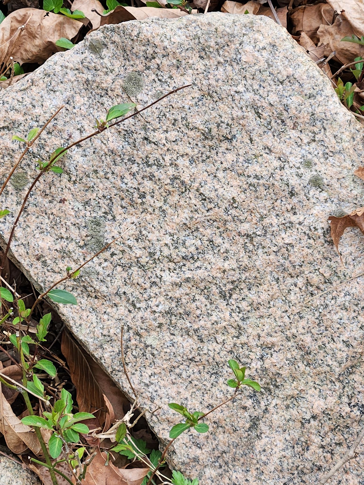
2. Do you see any large rocks around the parking area? Do you think these pieces are Guilford granite? Describe some colors you see and tell us if the grain size is visible to the naked eye.
3. At Waypoint #3, the small quarry pit. - Observe the water level today and tell us if it is higher, lower or level with the Little Patuxent River and why you think it is that way.
4. Post in your Log a picture of yourself (face not required) or a personal item. at the cache location.
Please visit our related Earth Cache near Granite, MD -
x Maryland’s Pink Granite - Woodstock Granite EarthCache - GCAMZEB
What is Granite? Granite is a dense igneous rock, formed as molten rock slowly cooled and crystallized. It is a mixture of feldspar, quartz, and mica (or biotite). These minerals create flecks of light and dark on a gray background, but the colors can range from black to pink.
These quarries produced a high quality granite called Guilford quartz monzonite which is located only in the southeastern part of Howard County. The rock is a muscovite-biotite granite of medium-gray color and of even, fine grain, with biotite uniformly disseminated and in excess of muscovite. It consists of potash feldspar (orthoclase and microcline), soda-lime feldspar (oligoclase), quartz, biotite, and muscovite, together with accessory zircon and apatite and secondary chlorite, epidote, muscovite, and kaolinite. Intergrowths of feldspar and quartz are numerous.
The quarry measures about 500 by 300 feet and has a depth of about 100 feet. The average depth of stripping is about 10 feet. The sheets, 3 to 10 feet thick, are approximately horizontal and tapering lenticular. Vertical joints strike north-south and eastwest, recurring at wide intervals. Many of the joint surfaces are slickensided, indicating movement in the granite mass. There are a few dark basic segregations (knots), the largest observed not exceeding 6 inches long by 3 inches wide. No pegmatite dikes were noted.1
Granite from here was used to construct the first St. Mary's Church in Laurel. The B&O Railroad used this granite for bridge abutments and culverts. It was also fashioned into cemetery monuments and cobblestones for the streets of Washington. In the city of Laurel, they uncovered granite curbs in 1971 that had been laid 75 years earlier along a mile-long section of Main Street. Smaller stones and irregular pieces were crushed by a stone crusher (the remains of one are along the path by the river) and used in road construction. However, river gravel was cheaper to obtain and soon replaced crushed granite for roadwork. 2
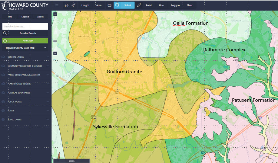
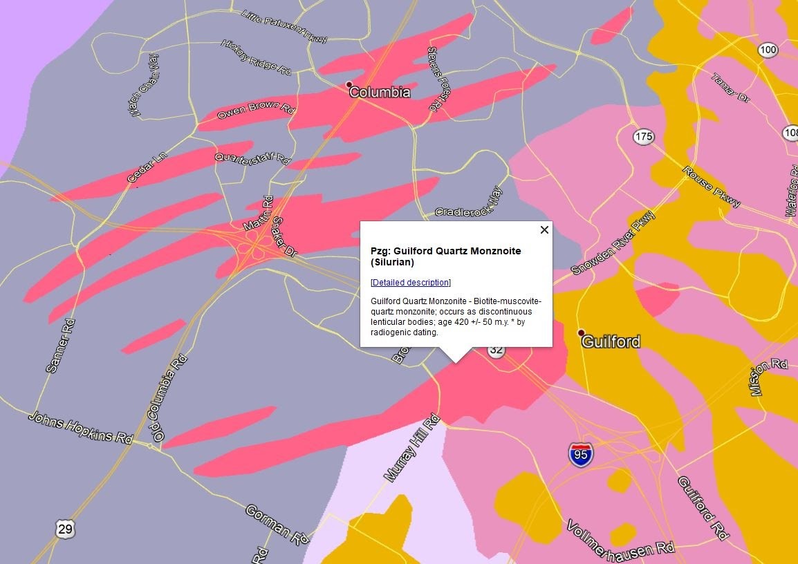
This map above from Howard County, MD shows the geology of the Guilford area including the distribution of Guilford Granite, found only in this area. The Patuxent Formation is largely sand and gravel and the Baltimore Complex is gabbro.3
The granite industry in Howard County was so geologically significant that the three main commercially quarried granites were named after Guilford, Ellicott City and Woodstock. The US Geological Survey describes this granite as “Guilford Quartz Monzonite,” dating back approximately 420 million years.
Guilford Granite is only found here in the Guilford and Atholton areas of Howard County, including an area around the Middle Patuxent River and represents only 1.5% of the geological units in the county. This granite differs only slightly from the Ellicott City granite which is described as “Ellicott City Granodiorite” and also dates to about 420 million years ago. Ellicott City granite is found in both Baltimore and Howard Counties. Woodstock Granite is another famous Howard County granite and a little darker in color than the Guilford granite. The Guilford, Ellicott City and Woodstock granites made a large economic and social impact on Howard County both with the B&O railroad, building and monument stones, and crushed stone for road bed materials.
The stones and quarries along the Wincopin Trails and the Patuxent Branch Trail south of the I-95 overpass are gabbro, which has a much darker color. Gabbro also has a higher iron content than granite and can appear with a rusty color on it. This stone was usually crushed and mostly used for road bed construction. Another fabled stone has been called “Blue Stone”, which seems to actually be a granite-type of stone called Gneiss which appears in the Sykesville Formation along the Middle Patuxent River.7
What is a Geological Unit? A geological unit is a volume of rock or ice of identifiable origin and age range that is defined by the distinctive and dominant, easily mapped and recognizable petrographic, lithologic or paleontologic features (facies) that characterize it.4
WHAT IS A Geologic FORMATION? A formation is a rock unit that is distinctive enough in appearance that a geologic mapper can tell it apart from the surrounding rock layers. It must also be thick enough and extensive enough to plot on a map. 5
So to sum up, a unit and a formation are basically synonymous with a formation being more specific.

https://ngmdb.usgs.gov/ngm-bin/pdp/zui_viewer.pl?id=61179
The first four "granites" and gneisses below were frequently used in buildings around Baltimore. In descriptions of buildings,these stones have often been confused, but with careful observation, the differences between them can easily be noted.
1. Port Deposit "Granite"..... a coarse-grained, granite gneiss with an obvious foliation produced by black mica. The rock was used in early days by colonial settlers, but commercial use did not occur until about 1816 when stone was needed for the abutments to the Susquehanna River Bridge. A quarry was established at Port Deposit and by the 1830's much of the stone was being shipped to Baltimore. Other quarries were opened in Cecil County as the stone gained acceptance. Some of the buildings in which this popular stone was used are: Fort Carroll, Fort McHenry, the Naval Academy in Annapolis, Haverford College in Philadelphia, and part of the old Goucher College in Baltimore. It is now quarried north of Havre de Grace by the Arundel Corporation for use as crushed stone.
2. Baltimore Gneiss..... any of several similar looking banded gneisses in a variety of colors, texture, and composition that were quarried along the Jones Falls and Gwynns Falls in Baltimore City. It is thought that the first buildings of Baltimore in the 1700's used stone quarried from the Jones Falls gneiss, near the old Mount Royal railroad shops. Many of the tone buildings, foundations, roads, and curbstones in Baltimore were built of rock from both the Jones Falls and Gwynns Falls quarries. The blue-gray color of fresh stone caused the term "blue stone" to be used by the quarrymen. The last building stone quarry in Baltimore closed in 1958.
3. Ellicott City "Granite"..... a porphyritic gneiss that was first quarried in the late 18th century. It was used in building the Basilica of the Assumption in Baltimore, which was erected during the period 1806 to 1821. Material was hauled from the Ellicott City area to Baltimore by huge wagons drawn by nine yoke of oxen. After 1892, the stone was used primarily in foundations and as paving stone. Little building stone was produced from this area after 1896.
4. Woodstock Granite..... a pinkish-toned, coarse-grained, gray granitic rock that was quarried near the town of Granite in Baltimore and Howard counties. This rock was first quarried in 1832 and was used intermittently until the 1920's. It was employed as a monument stone as well as being used for building exteriors. Buildings made from this stone include: parts of the Capitol building and the Library of Congress in Washington, D.C., the Baltimore Customs House, and the old Baltimore County Court House. Many curbstones, paving blocks and bridges are made of this stone.
5. Cockeysville Marble... a white, crystalline, metalimestone, most famous for its use in the Washington Monument in Washington, D.C. The first 152 feet of the monument, built between 1845 and 1854, were faced with Cockeysville stone from a quarry near Texas, about 12 miles north of Baltimore. When funds were depleted, work ceased for 25 years and was resumed again in 1879 using a marble from Lee, Massachusetts. Four courses of this stone were used; however, it proved too costly and the remainder of the structure was faced with marble from a quarry in the Cockeysville area. The marble was also used in the construction of the Washington Monument in Baltimore City. By the 1840's-1850's, the marble was very popular and readily available for use in building the stone front steps of many of the older row houses in Baltimore. The Beaver Dam quarry at Cockeysville furnished marble used for the 108 columns in the wings of the National Capitol at Washington, D.C. Today, quarries work the Cockeysville Marble primarily for crushed stone and high-purity calcite.
6. Slate..... a bluish-gray, thin-bedded, fade resistant slate was quarried from the Peach Bottom-Cardiff area in Harford County and, to a lesser extent,from the Ijamsville area in Frederick County. The Peach Bottom area was worked as early as 1750 for local use. The first commercial Peach Bottom quarry opened in 1812, about the same time that work began in the Ijamsville area. The Ijamsville slates did not achieve the popularity afforded those from Peach Bottom because of their dullness and softness or lack of "ring," and operations closed in 1892. Slate was quarried from Peach Bottom as late as 1957 for granules in composition roofing shingles.
7. "Seneca Red" Sandstone..... a reddish to purplish brown, fine-grained, arkosic sandstone or "Brownstone" was quarried extensively along the Potomac River in Montgomery and Frederick Counties. This Triassic stone was initially used for the "Potowmack Canal" built around 1774 and again for the C & O Canal in the early 1830's. In 1847, it was used to build the Smithsonian Institution Building in Washington, D.C. The stone is readily carved and chiseled when first quarried but later hardens on exposure to air. There is a tendency of the rock to spall if laid "on edge," therefore, careful placement was required.
8."Potomac Marble"..... also known as "calico rock" or "Potomac Breccia," is a multi-colored conglomerate of Triassic age and is composed of rounded quartz and limestone pebbles cemented in a calcareous matrix. Benjamin Latrobe first reported finding this rock in 1815. This stone, probably quarried from Montgomery County, was used for the twenty-foot columns in the old U.S. House of Representatives (now Statuary Hall). The stone was quarried primarily in Frederick County, most extensively along the Potomac River, near Washington Junction.
9, Wakefield Marble..... a variegated marble used for altar fronts and interior decorations was quarried in Carroll and Frederick Counties. The colors range from "deep red," "salmon," "lavender veined," "undulated pink and white," "ruby" to black to white. The marble's variety of color was its drawback, as it was neither consistent nor predictable. The marble was worked around the turn of the 20th century.
10. Serpentinite..... a patterned rock occurring in various shades of green from pale leek to greenish black that has been used both as a building stone and as a sawed and polished ornamental stone. Serpentinite from Baltimore County was used to build the Mount Vernon Place Methodist Church in Baltimore City. Cut and polished, it is also known as "Maryland Green Marble" or "verde antique." Stone from Broad Creek was shipped to New York and was used in the Empire State Building in New York City.
11. Sykesville Gneiss..... a dark gray, often schistose gneiss with a roughly rectangular fracture pattern is currently being quarried near Potomac in Montgomery County and was at one time used extensively in the Washington, D.C. area for foundation and rubble stone. The stone was first worked commercially as "granite" about 1850. The early settlers in the Washington area used many of the schists and gneisses found along the Potomac River. This Sykesville stone may be what was once known as "Potomac Bluestone."
12. Setters Quartzite..... a thinly layered tan quartzite that has been used for many years as a flagstone and as building material. Tourmaline crystals are often present on cleavage surfaces. The stone has become popular in recent years for use in many of the houses and buildings in Towson and Baltimore. It is currently being quarried near Marriottsville in both Howard and Baltimore Counties.
13. Paleozoic Sandstones..... four sandstone beds which range in age from Silurian to Mississippian have been quarried in Western Maryland for use in that area. The Tuscarora sandstone has been used for foundation stones and trim in many of the older buildings at Cumberland. The Oriskany, a yellow to buff sandstone was also widely used there; however the stone is soft and tends to disintegrate with time. Currently, both the Pocono, a thin-bedded brown sandstone, and the Pottsville, a massive gray conglomeratic sandstone, have limited use for flagstone, building facing, and rubble stone.
Many other rock formations were used throughout Maryland for building material. Often these were simply rocks picked up near the site of construction and are termed "fieldstone." Initially, most building stone was obtained this way, but about 1825 technology and transportation had developed to the point that it was feasible to quarry stone at specific sites. 8
Permission received from Howard County Department of Recreation and Parks for this cache.
 |
CONGRATULATIONS - First To Find - RDip
Second To Find - Dancing Golphers
Third To Find - Butterfly_TeamBnB
Sources:
1 mindat.org
2 Howard County Department of Recreation and Parks.
3 Howard County GIS. 2020. Interactive Map. https://data.howardcountymd.gov/InteractiveMap.html
4 https://fossil.fandom.com/wiki/Geological_unit
5 https://geology.utah.gov/map-pub/survey-notes/glad-you-asked/what-is-a-formation/
6. Maryland Geological Survey - Resource Assessment Service - Maryland Department of Natural Resources
7 https://sites.google.com/view/guilfordhistoryhoco/home/did-you-know/did-you-know-5-guilford-granite-is-an-official-geologic-unit
8.http://www.mgs.md.gov/geology/building_stones_of_maryland.html
Cleaves, E.T., Edwards, J., Jr., and Glaser, J.D., 1968. Geologic Map of Maryland: Maryland Geological Survey, Baltimore, Maryland
National Park Service. 2020. National Building Stone Database