
► Local geological context
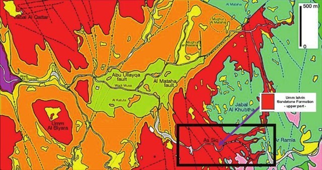
The Petra region is located on a vast Palaeozoic sedimentary complex starting on the eastern shores of the Dead Sea and descending along a north-south axis to the Red Sea.
At Petra, a formation dating from the Cambrian predominates, that of Umm Ishrin.
► The Umm Ishrin detritic sedimentary formation
The Umm Ishrin formation is a detritic sedimentary rock laid down by successive deposits of terrigenous elements in a fluvial or benthic setting (quartz or limestone grains).
These deposits sank, resulting in their cementation in a mineral matrix (diagenesis).
In the Umm Ishrin formations, this matrix contains a high proportion of oxidised iron (ferruginous matrix), giving it its characteristic reddish colour.
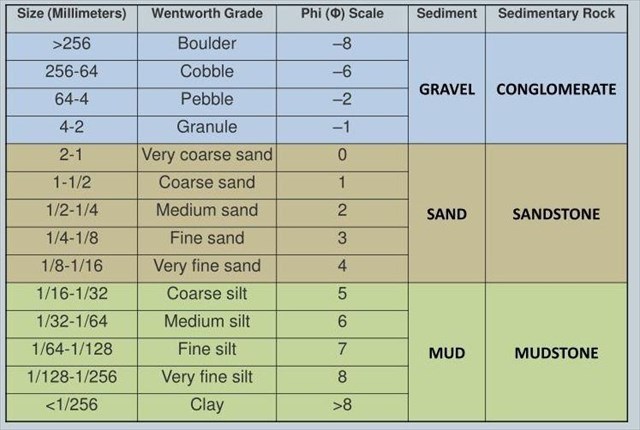
It is possible to characterise the nature of a detritic sedimentary formation by the size of the sediments that make it up, using the Wentworth scale.
► Factors and forms of weathering in the rocks of Umm Ishrin
The forms of erosion shaping Petra's distinctive landscapes are strongly linked to:
- the petrographic characteristics of the rock (texture, structure), characterised by sedimentary rock that is more or less sensitive to mechanical friction (friability).
- environmental conditions (hydrogeology, hydrology).
~ Alteration factors at Petra
- Run-off: during heavy rainfall, which is rare but intense, this causes powerful vertical mechanical erosion (here at the origin of the Siq).
- Freezing/thawing: this causes the stone to shatter, depending on the porosity of the material, giving it an angular appearance.
- The development of micro-organisms and plants whose acid secretions dissolve the rock matrix. This type of weathering occurs on north-facing surfaces that are not exposed to much sunlight.
- The accumulation of water on horizontal surfaces, leading to hydrolysis of the rock and the formation of cupules (horizontal oblong hollows).
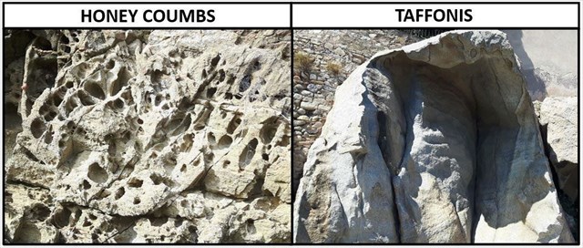
- Alveolar alteration by thermoclastie, certainly the most spectacular form of alteration.
~ Thermoclastic weathering
Depressed areas of the rock undergo cycles of wetting/drying + heating/cooling, resulting in variations in the volume of water forming areas of overpressure that degrade the ferruginous cement in the rock.
As the areas sheltered from the sun (top of the cavity) are wetter, this degradation mechanism is accelerated, pushing the alveolisation upwards.
In addition to these cycles, wind deflation occurs to remove fine debris, leaving hollow cavities that often face upwards.
This results in two characteristic forms of weathering, depending on the size of the cavities:
- Up to 10 centimetres, the cells, often arranged in a quasi-geometric pattern, resemble the cells of a beehive, hence the term "honeycomb" erosion.
- Beyond 10 centimetres, we move on to a more advanced form of alveoli, the taffoni.
► Questions to validate "The Elephants of Petra".
- Question 0 : Take a photo of yourself or of an element identifying you on the site but does not show the observation area.
This photo will have to be sent to us with the answers or to be added to your log.
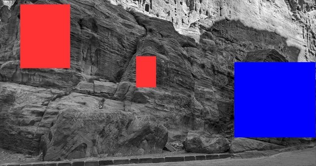
Here you are at an area of the Siq where it is possible to observe some particularly remarkable forms of cliff degradation (on the right-hand side as you descend towards the Treasury - photo WP1).
- Question 1 : Take a close look at the rock. What is the average grain size? Deduce its nature from the Wentworth diagram.
- Question 2 : Rub the palm of your hand lightly against the rock. What do you observe? Deduce its sensitivity to mechanical alteration.
- Question 3 : Describe the forms of alteration under the two red areas on the left of photo WP1 (size, shape, etc.). Deduce the name of this form of deterioration and the main element causing it.
- Question 4 : Based on your previous observations, do you think that the elephants in Petra (under the blue area) are statues sculpted by the Nabataeans?
You can log this cache without waiting for our confirmation,
but you must send us the answers at the same time, by e-mail via our profile (
fafahakkai) or by the system of Message Center of geocaching.com.
If there is a problem with your answers we will notify you.
The logs recorded without answers will be deleted.
Reminder concerning "Earthcaches": there is neither a container to look for nor a logbook to sign. One need only go to the location, answer to the differents questions and send us the answers.

السياق الجيولوجي المحلي ◄
تقع منطقة البتراء على مجمع رسوبي شاسع من العصر الباليوزوي يبدأ من الشواطئ الشرقية للبحر الميت وينحدر على طول محور الشمال والجنوب إلى البحر الأحمر.
يهيمن على البتراء تكوين أم إشرين، الذي يعود تاريخه إلى العصر الكمبري.
التكوين الرسوبي التحريفي لأم إشرين ◄
تكوين أم إشرين، وهو عبارة عن صخور رسوبية انفصالية ترسبت بفعل ترسبات متتالية من العناصر الطينية في بيئة فلوفية أو قاعية (حبيبات الكوارتز أو الحجر الجيري).
غاصت هذه الترسبات مما أدى إلى ترسيخها في مصفوفة معدنية (دياجينيسيسيس).
تحتوي هذه المصفوفة في تكوينات أم إشرين، على نسبة عالية من الحديد المؤكسد (مصفوفة حديدية)، مما يعطيها لونها الأحمر المميز.
من الممكن توصيف طبيعة التكوينات الرسوبية المتفتتة من خلال حجم الرواسب التي تتكون منها باستخدام مقياس وينتورث.
عوامل وأشكال التعرية في صخور أم زرعين ◄
ترتبط أشكال التعرية التي تشكل المناظر الطبيعية المميزة للبتراء ارتباطاً وثيقاً بـ
- الخصائص البتروغرافية للصخور (الملمس والتركيب)، التي تتميز بها الصخور الرسوبية التي تكون أكثر أو أقل حساسية للاحتكاك الميكانيكي (قابلية التفتيت).
- الظروف البيئية (الهيدروجيولوجيا والهيدرولوجيا).
عوامل التغير في البتراء ~
- الجريان السطحي: أثناء هطول الأمطار الغزيرة، وهو أمر نادر الحدوث ولكنه شديد، وهذا يسبب تآكل ميكانيكي عمودي قوي (هنا في أصل السيق).
- التجمد/الذوبان: يؤدي ذلك إلى تحطم الحجر، اعتماداً على مسامية المادة، مما يعطيها مظهراً زاويًا.
- تطوّر الكائنات الحية الدقيقة والنباتات التي تعمل إفرازاتها الحمضية على إذابة المصفوفة الصخرية. ويحدث هذا النوع من التجوية على الأسطح المواجهة للشمال التي لا تتعرض لأشعة الشمس كثيراً.
- تراكم الماء على الأسطح الأفقية، مما يؤدي إلى تحلل مائي للصخور وتكوين كوبيات (تجاويف أفقية مستطيلة).
- التغيّر السنخي بالحرارة، وهو بالتأكيد أكثر أشكال التغيّر إثارة.
التغير الخلوي الحراري الخلوي ~
تخضع المناطق المنخفضة من الصخور لدورات من الترطيب/التجفيف + التسخين/التبريد، مما يؤدي إلى تغيرات في حجم المياه التي تشكل مناطق من الضغط الزائد الذي يؤدي إلى تحلل الإسمنت الحديدي في الصخر.
عندما تكون المناطق المحمية من الشمس (أعلى التجويف) أكثر رطوبة، تتسارع آلية التحلل هذه، مما يدفع الحويصلات الهوائية إلى الأعلى.
وبالإضافة إلى هذه الدورات، يحدث انكماش بفعل الرياح لإزالة الحطام الناعم، تاركاً تجاويف مجوفة غالباً ما تكون متجهة إلى الأعلى.
وينتج عن ذلك شكلين مميزين من أشكال التجوية، اعتماداً على حجم التجاويف:
- حتى 10 سنتيمترات، تشبه الخلايا، التي غالباً ما تكون مرتبة في نمط شبه هندسي، خلايا خلية النحل، ومن هنا جاء مصطلح التآكل "قرص العسل".
- أما بعد 10 سنتيمترات، ننتقل إلى شكل أكثر تقدماً من الحويصلات الهوائية وهو التافوني.
► أسئلة التحقق من صحة "أفيال البتراء
- السؤال 0: التقط صورة لنفسك أو لشيء يحدد هويتك في الموقع ولكن لا تظهر منطقة المراقبة.
يمكن إرسال هذه الصورة إلينا مع إجاباتك أو إضافتها إلى سجلك.
أنت هنا في نقطة على السيق حيث يمكن ملاحظة بعض الأشكال الرائعة بشكل خاص لتدهور الجرف (على الجانب الأيمن وأنت تنحدر نحو الخزانة - الصورة WP1
السؤال 1: ألقِ نظرة فاحصة على الصخرة. ما هو متوسط حجم الحبيبات؟ استنتج طبيعتها من مخطط وينتورث.
السؤال 2: افرك راحة يدك برفق على الصخرة. ماذا تلاحظ؟ استنتج حساسيتها للتغيُّر الميكانيكي.
السؤال 3: صف أشكال التجوية تحت المنطقتين الحمراوين في الصورة WP1 (الحجم والشكل، إلخ) واستنتج آلية التحلل والعنصر الرئيسي المسبب له.
السؤال 4: استناداً إلى ملاحظاتك السابقة، هل تعتقد أن أفيال البتراء (تحت المنطقة الزرقاء) هي تماثيل منحوتة من قبل الأنباط؟
يمكنك تسجيل الدخول دون انتظار تأكيدنا، ولكن يجب أن ترسل لنا الإجابات في نفس الوقت، إما عن طريق البريد الإلكتروني عبر ملفنا الشخصي (fafahakkai)، أو عبر نظام المراسلة geocaching.com (مركز الرسائل).
إذا كانت هناك أي مشاكل في إجاباتك سنقوم بإعلامك. سيتم حذف أي سجلات مسجلة بدون ردود.
تذكير بشأن مخابئ Earthcaches: لا توجد حاوية للبحث عنها ولا يوجد سجل لملئه. فقط اذهب إلى

► Contexte géologique local
La région de Petra se situe sur un vaste ensemble sédimentaire du Paléozoïque démarrant sur les côtes orientales de la Mer Morte et descendant selon un axe Nord-Sud jusqu'à la Mer Rouge.
Au niveau de Petra, une formation datant du Cambrien prédomine, celle d'Umm Ishrin.
► La formation sédimentaire détritique d'Umm Ishrin
La formation d'Umm Ishrin est une roche sédimentaire détritique mise en place par des dépôts successifs d'éléments terrigènes dans un cadre fluvial ou benthique (grains de quartz ou de calcaire).
Ces dépôts se sont enfoncés entrainant leur cimentation dans une matrice minérale (diagenèse).
Dans les formations d'Umm Ishrin, cette matrice contient une forte proportion de fer oxydé (matrice ferrugineuse) lui donnant sa couleur caractéristique rougeâtre.
Il est possible de caractériser la nature d'une formation sédimentaire détritique par la taille des sédiments qui la composent en utilisant l'échelle de Wentworth.
► Facteurs et formes d'altération des roches d'Umm Ishrin
Les formes d'érosion façonnant les paysages si particuliers de Petra sont fortement liées :
- aux caractéristiques pétrographiques de la roche (texture, structure), se caractérisant par une roche sédimentaire plus ou moins sensibles aux frottements mécaniques (friabilité).
- aux conditions du milieu (hydrogéologie, hydrologie).
~ Facteurs d'altération à Petra
- Le ruissellement : lors des forts épisodes de précipitations, rares mais intenses, cela provoque une érosion mécanique verticale puissante (ici à l'origine du Siq).
- Le gel/dégel : fait éclater la pierre selon la porosité du matériau, lui donnant un aspect anguleux.
- Le développement de micro-organismes et végétaux dont les sécrétions acides dissolvent la matrice de la roche. Cette forme d'altération se produit sur les faces nord peu exposées au soleil.
- L'accumulation d'eau sur des surfaces horizontales entrainant une hydrolyse de la roche et formant des cupules (creux oblongues horizontaux).
- L'altération alvéolaire par thermoclastie, certainement la forme la plus spectaculaire d'altération.
~ L'Altération alvéolaire thermoclastique
Des zones déprimées de la roche subit des cycles mouillage/séchage + chauffage/refroidissement entrainant des variations de volume de l'eau formant des zones de surpression qui dégradent le ciment ferrugineux de la roche.
Les endroits à l'abri du soleil (haut de la cavité) étant plus humides, ce mécanisme de dégradation y est accéléré, poussant l'alvéolisation vers le haut.
En complément de ces cycles, une déflation éolienne intervient pour évacuer les débris fins, laissant des cavités creuses souvent orientées vers le haut.
Il en résulte deux formes d'altération alvéolaire caractéristiques selon la taille des alvéoles :
- Jusqu'à 10 centimètres, les alvéoles, souvent disposées de façon quasi géométrique, évoquent des alvéoles de ruches d'où le terme d'érosion en « nid d’abeilles ».
- Au delà de 10 centimètres, on passe à une forme plus évoluée des alvéoles, les taffonis.
► Questions de validation pour "Les Eléphants de Petra"
- Question 0 : Prenez une photo de vous ou d'un élément vous identifiant sur le site mais sans montrer la zone d'observation.
Cette photo devra au choix nous être transmise avec les réponses ou être ajoutée à votre log.
Vous voici à un endroit du Siq ou il est possible d'observer des formes de dégradation des falaises particulièrement remarquables (côté droit quand on descend vers le Trésor - photo WP1).
- Question 1 : Observez la roche de près. Quelle est la taille moyenne des grains la composant ? Déduisant sa nature selon le diagramme de Wentworth.
- Question 2 : Frottez légèrement la paume de votre main contre la roche. Qu'observez vous ? Déduisez en sa sensibilité à altération mécanique.
- Question 3 : Décrivez les formes d'altération sous les 2 zones rouges de la photo WP1 (taille, forme,...) et déduisez en le mécanisme de dégradation et le principal élément qui en est à l'origine.
- Question 4 : D'après vos précédentes observations, pensez-vous que les Eléphants de Petra (sous la zone bleue) sont des statues sculptées par les Nabatéens ?
Vous pouvez vous loguer sans attendre notre confirmation,
mais vous devez nous envoyer les réponses en même temps soit par mail via notre profil (
fafahakkai), soit via la messagerie geocaching.com (Message Center).
S'il y a des problèmes avec vos réponses nous vous en ferons part.
Les logs enregistrés sans réponses seront supprimés.
Rappel concernant les « Earthcaches »: Il n'y a pas de conteneur à rechercher ni de logbook à renseigner. Il suffit de se rendre sur les lieux, de répondre aux questions ci-dessus et de nous renvoyer les réponses.
 Bibliographic sources / Sources bibliographiques