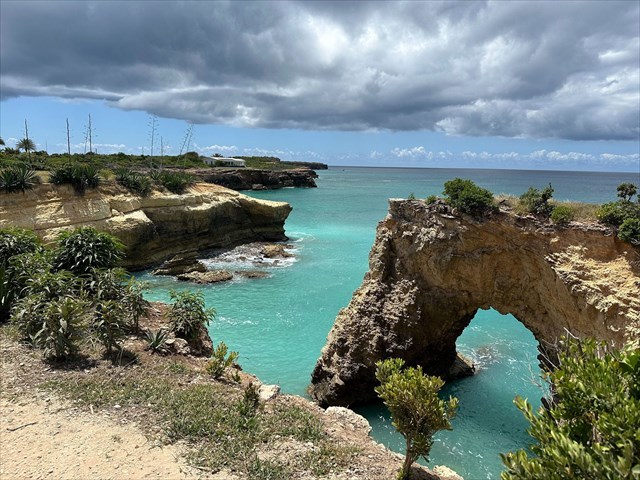
Anguilla is a British Overseas Territory that is located in the Eastern Caribbean, and is renowned for its pristine beaches, turquoise waters, and laid-back atmosphere. This small island paradise offers a perfect blend of luxury and simplicity, with upscale resorts dotting its coastline alongside charming local eateries. If you've spent some time exploring the island, you've probably noticed that the coastline in this part of the island is drastically different from the rest of the island, which contains the sandy beaches that the island is famous for.
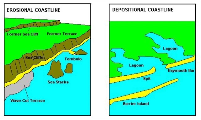
These differences can be explained through the study of emergent (erosional) and submergent (depositional) coastlines, which are distinct categories that describe coastal landforms relative to sea level. Emergent coastlines signify areas where landforms are rising in relation to sea level or where sea levels are declining. These coastlines often exhibit features like raised beaches, sea cliffs, and marine terraces, which result from geological processes such as tectonic uplift. The Caribbean region experiences a significant number of earthquakes annually, ranging from small tremors to more impactful events. One sign of prior tectonic activity is by the presence of tilted rock layers. In contrast, submergent coastlines are characterized by landforms sinking relative to sea level or where sea levels are rising. They key word is relative, so for example if sea levels drop, then it would appear as if the coastal landform was rising (since more of it would be visible above the water surface). This would make it an emergent coastline. The opposite would happen if sea levels rose, since less of the coastal landform would be visible, it would appear as if it is being submerged, and therefore be a submergent coastline. It is the same with tectonic uplift, if the landform moves upward relative to sea level, it is an emergent coastline, while if it moves downward, it is submergent.
One question you may have is why this stretch of coastline is significantly different from the rest of the island, where you have flat sandy beaches a few miles away. First, it is possible to have emergent coastlines situated relatively close to submergent coastlines. Second, these differences can be due to several different factors. For example, tectonic activity might cause one section of coastline to experience uplift. Additionally, local variations in factors such as sediment deposition, erosion rates, or sea level changes can further contribute to the differentiation between emergent and submergent coastlines over short distances.
Logging Requirements:
- Describe the morphology (shape) of the coastline in front of you. What features confirm that you are looking at an emergent coastline?
- Based on your observations, why do you think an emergent coastline is present in this area, when only a few miles away, sandy beaches, which are typical features of the island, are prevalent? Explain your answer.
- Upload a photo taken near the posted coordinates. You don't have to be in the photo, though it is strongly recommended.