| English: |
French: |
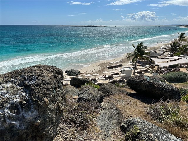
| Orient Beach is located in the northeast part of Saint Martin and is famous for its pristine white sands and turquois blue waters. Stretching nearly 2 kilometers along the Atlantic Ocean, it ranks among the largest and most popular beaches on the island. If you've spent some time exploring the beach, you may have noticed the massive boulders, which are a popular sunning spot for the local iguanas. |
La plage Orient est située dans la partie nord-est de Saint-Martin et est célèbre pour ses sables blancs immaculés et ses eaux turquoise. S'étendant sur près de 2 kilomètres le long de l'océan Atlantique, elle figure parmi les plages les plus grandes et les plus populaires de l'île. Si vous avez passé un peu de temps à explorer la plage, vous avez peut-être remarqué les énormes rochers, qui sont un endroit de prédilection pour lézarder au soleil pour les iguanes locaux. |
| Before we go into the geologic processes through which these boulders were formed, first let's learn about how the island was formed. Saint Martin is part of the arc of the Lesser Antilles, which stretches south from Puerto Rico towards the South American coastline. The island was formed 50 million years along, along the boundary of two tectonic plates. The South American plate pushed underneath the Caribbean Plate, which generated volcanic activity. While the island was still submerged, coral reefs grew on volcanic rocks, forming large limestone plateaus, some of which were pushed up to the surface of the sea. The three main types of rocks found on Saint Martin are limestone formations, volcanic rocks, and plutonic rocks. |
Avant d'entrer dans les processus géologiques à travers lesquels ces rochers ont été formés, commençons d'abord par apprendre comment l'île a été formée. Saint-Martin fait partie de l'arc des Petites Antilles, qui s'étend vers le sud depuis Porto Rico jusqu'au littoral sud-américain. L'île s'est formée il y a 50 millions d'années, le long de la frontière de deux plaques tectoniques. La plaque sud-américaine s'est enfoncée sous la plaque caribéenne, ce qui a généré une activité volcanique. Pendant que l'île était encore submergée, des récifs coralliens ont poussé sur des roches volcaniques, formant de vastes plateaux calcaires, dont certains ont été poussés à la surface de la mer. Les trois principaux types de roches trouvés à Saint-Martin sont les formations calcaires, les roches volcaniques et les roches plutoniques. |

| Now that we understand how Saint Martin was formed, let's learn about the geologic processes which formed the boulders in front of you. In subduction zones, where one tectonic plate is forced beneath another, a massive amount of heat and pressure are exerted on the rock layers. This extreme environment causes the molten magma to rise towards the Earth's surface. As the magma cools, the volcan rock contracts. This contraction creates a network of fractures, often forming distinct geometric shapes. You can think of it similar to what happens with hot glass when you remove it from the oven, and then pour cold water on it, this rapid cooling would cause it to crack. If the cooling occurs uniformly, the fractures will form at regular intervals in multiple directions. The rate of cooling influences the spacing of these fractures. Rapid cooling results in these fractures being located closer together, while slow cooling results in them being spaced further apart. Over time, the joints are eroded by rainfall and runoff, which then rounds the boulders over time. |
Maintenant que nous comprenons comment Saint-Martin a été formée, apprenons-en davantage sur les processus géologiques qui ont formé les rochers devant vous. Dans les zones de subduction, où une plaque tectonique est forcée sous une autre, une énorme quantité de chaleur et de pression est exercée sur les couches de roche. Cet environnement extrême fait que le magma en fusion remonte vers la surface de la Terre. Lorsque le magma refroidit, la roche volcanique se contracte. Cette contraction crée un réseau de fractures, formant souvent des formes géométriques distinctes. Vous pouvez le comparer à ce qui se passe avec du verre chaud lorsque vous le retirez du four, puis que vous y versez de l'eau froide, ce refroidissement rapide le ferait craquer. Si le refroidissement se produit uniformément, les fractures se formeront à intervalles réguliers dans plusieurs directions. Le taux de refroidissement influence l'espacement de ces fractures. Un refroidissement rapide entraîne ces fractures à être situées plus près les unes des autres, tandis qu'un refroidissement lent entraîne leur éloignement. Au fil du temps, les joints sont érodés par les précipitations et les ruissellements, ce qui arrondit ensuite les rochers au fil du temps. |
| Logging Requirements: |
Exigences de journalisation: |
- Examine some of the boulders and the surrounding joints. Are the direction or angle of the joints symmetrical, or do they vary? Also, are they spaced at regular intervals, or does the spacing vary? What can this tell us about the rate at which these rocks cooled?
- If you look around, you'll notice that the surrounding area is mostly flat, and this spot doesn't exactly fit in with the surrounding topography. Why do you think this "hill" with the massive boulders exists in this spot (hint: think about how the island was formed)?
- Upload a photo taken near the posted coordinates with either the boulders or Orient Beach in the background. You don't have to be in the photo, though it is strongly encouraged.
|
- Examinez certains des rochers et des joints environnants. La direction ou l'angle des joints sont-ils symétriques, ou varient-ils ? De plus, sont-ils espacés à intervalles réguliers, ou l'espacement varie-t-il ? Que cela peut-il nous dire sur la vitesse à laquelle ces roches ont refroidi ?
- Si vous regardez autour de vous, vous remarquerez que la zone environnante est principalement plate, et cet endroit ne correspond pas exactement à la topographie environnante. Pourquoi pensez-vous que cette "colline" avec les énormes rochers existe à cet endroit (indice : réfléchissez à la façon dont l'île a été formée) ?
- Téléchargez une photo prise près des coordonnées indiquées avec soit les rochers, soit la plage d'Orient en arrière-plan. Vous n'avez pas besoin d'être sur la photo, bien que cela soit fortement encouragé.
|
|