LOGGING REQUIREMENTS
In order to log this EarthCache, send me your answers to the following questions either through email or messaging from my profile page.
1: Describe the layers that make up this mushroom rock. Please include height/width/color.
2: Of these layers, which do you think is the softest rock? Which is the hardest?
3: Do you think wind or rock hardness is the bigger factor in the erosion of this mushroom rock? Give a reason for your answer.
4: Post a pic of you or a signature item with the mushroom rocks in the background.
WHY HERE?
This EarthCache is along the Pothole Point loop trail. You will be able to walk right up to, around and even under parts of the mushroom rock.
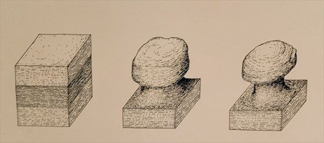
HOW DO MUSHROOMS FORM?
Mushroom rocks, also known as rock pedestals or gours, are naturally occurring landforms that develop a mushroom-like shape through erosion and weathering. Wind erosion is a common cause of mushroom rock formation in deserts. As wind carries sand particles close to the surface, they hit the bottom of the rock more than the top, gradually carving it into a narrow base and wide upper section. In some cases, harder rocks may be arranged horizontally over softer rocks, which can also lead to this type of erosion.
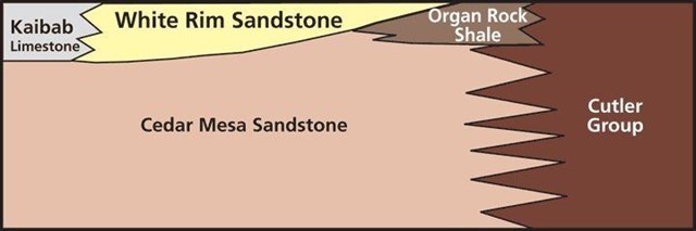
CEDAR MESA SANDSTONE
This area of Canyonlands National Park is in the Cedar Mesa Sandstone geological layer. Cedar Mesa Sandstone is the remains of coastal sand dunes deposited about 270 to 300 million years ago, during the early Permian period. The distinctive red and white banding is caused by two different rock formations interfingering. The red sandstone is from the Organ Rock tongue of the Cutler formation. It was deposited in a riverbed, while the white sandstone, also of the Cutler formation, was deposited near the shore of an ancient sea as sand dunes.
references
https://npshistory.com/
https://www.nps.gov/cany/
https://www.moabhappenings.com/Archives/Geology201906-WhiteRimSandstone.htm
I have earned GSA's highest level:
 |