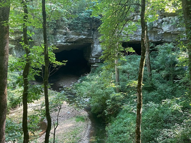
Russell Cave National Monument, located in northeast Alabama, is a site of immense archaeological and historical importance. It provides a comprehensive record of human habitation spanning over 10,000 years, making it one of the most significant prehistoric sites in the southeastern United States. Excavations at the cave have uncovered a wealth of artifacts and remains, including tools, pottery, and burial items, which offer profound insights into the daily lives, diets, and cultural practices of prehistoric Native American cultures. Russell Cave is also one of the longest caves in Alabama, with 13 miles of passageways mapped so far. After rainfall, Dry Creek flows into the "wet entrance" of the cave, traveling underground before resurfacing at Widows Spring, located several kilometers southeast of the monument.
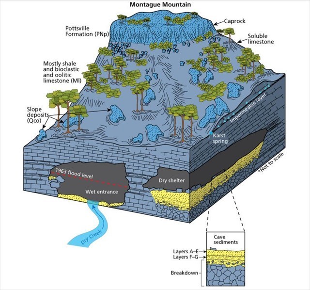
Russell Cave was created by the dissolution of limestone (geologic map unit Ml) beneath a durable layer of sandstone (PNp). These two types of bedrock, which make up the monument, originated from sediments deposited in a shallow sea over 300 million years ago. Over millions of years, carbonate deposits accumulated in what was once an inland sea, forming the thick carbonates of the Monteagle and Bangor limestones (mapped collectively as Ml). The deposition of mixed sandstone and conglomerate (which is a coarse grained rock composed of rounded gravel sized clasts cemented together) from the Pottsville Formation (PNp) atop these carbonates created an erosion resistant cap rock. Groundwater infiltrating through fractures and fissures in the carbonates dissolved the rocks away, forming increasingly wider conduits and caverns beneath the cap rock.
Between 9,000 and 11,000 years ago, the roof of a cavern collapsed beneath the northeastern flank of Montague Mountain, forming a sinkhole that redirected the flow of Dry Creek and exposed the entrance to Russell Cave. Subsequent ceiling collapses and sediment accumulation created a dry shelter perched 24 feet above the Dry Creek channel. The main entrance to Russell Cave, divided into a "dry" and a "wet" entrance by a large rock pillar, formed from these collapses and sediment deposits. During past archaeological digs, the cave sediments were also studied and labeled as layers A through G (with A being the uppermost layer, and G at the bottom), which sit atop a breakdown layer. Layers G and F, deposited by occasional flooding, showed crossbedding indicative of flowing water and contained evidence of human activity such as charcoal pellets and mussel shells from the Tennessee River. Inhabitants leveled off the upper surface of layer F, and subsequent sediments show no signs of flooding. Layer E, horizontally bedded with several fire pit layers, burned limestone, mussel shells, and bone fragments, shows no evidence of water-related deposition and is similar to the adjacent limestone with abundant oolite fragments. Layer D, was deposited atop layer E, contains abundant clay and other materials possibly spread by cave inhabitants. The uppermost layers consist mainly of material derived from the cave walls, mixed with charcoal and shells.
One other topic worth mentioning involved cave breathing. During the summer, air flows out from cave entrances at the base of Montague Mountain, suggesting the presence of additional entrances higher up the slopes. This phenomenon occurs because caves "breathe" in response to changes in barometric pressure and temperature at the surface. When external barometric pressure increases, air is pushed into the cave, and when the pressure decreases, the airflow is reversed.
Please remain on the trail at all times. All observations can be made from the boardwalk.
Logging Requirements:
- Compare and contrast the two cave entrances (Wet Entrance and the Dry Shelter). Why do you think they look different from one another despite being right next to each other?
- Do you see any signs of erosion (which would indicate that the cave is continuing to be enlarged)? If so, explain what you see and where.
- Upload a photo taken with Russell Cave or the Dry Shelter. You don't have to be in the photo, though it is strongly encouraged.