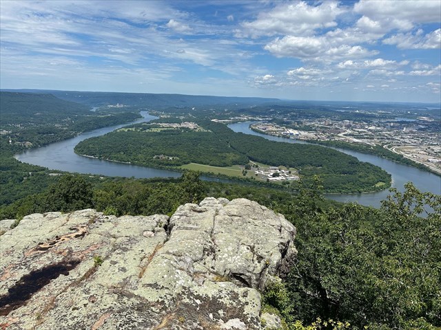
The Battle of Lookout Mountain was fought on November 24, 1863, during the Civil War. This battle was a key engagement in the Chattanooga Campaign, where Union forces under Major General Ulysses S. Grant launched an assault against the Confederate Army of Tennessee, commanded by General Braxton Bragg. The Union troops, advancing up the steep slopes of Lookout Mountain in a dramatic and challenging fight, achieved a significant victory that played a crucial role in breaking the Confederate siege of Chattanooga. The battle earned the nickname "Battle Above the Clouds" due to the dense fog that enveloped the mountain during the fighting. The listed coordinates will bring you to Point Lookout, which was one of the most photographed places during the Civil War, with thousands of images being taken from the mountain point.
At Point Lookout, there is a unique opportunity to learn about joints and stresses found within rocks. However first it is important to be familiar with some of the geology of Lookout Mountain. Geologically, the stones near the top of the mountain are part of the Pennington Formation, which is characterized by a diverse mix of rock types, including shale, sandstone, and limestone. The shale is primarily argillaceous (contains clay or clay minerals), olive-gray in color, and often displays red and green hues. The sandstone within the formation ranges from greenish-gray to grayish-orange, and is fine to medium grained, and can be thin or thick bedded. It may also contain thicker sandstone layers, up to 60 feet thick in the upper parts of the formation, which may contain small, scattered quartz pebbles. Limestone in the Pennington Formation varies from light olive-gray to yellowish-brown, is fine to medium grained, and exhibits thin to thick bedding. The limestone is mostly fossil fragmental (which means that it is composed of broken pieces of fossils), with some oolitic zones (this is a type of limestone that contains oolites, which are small spherical grains).
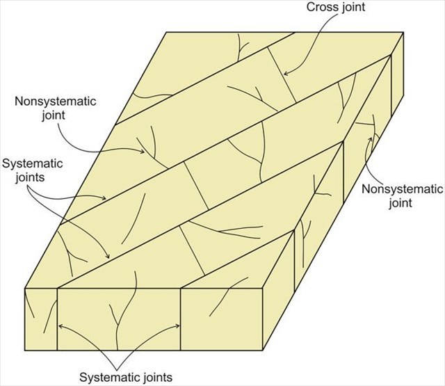 The joints you see can be classified as either systematic or non-systematic. Systematic joints are fractures in rock that are regularly spaced and have a consistent orientation, they often form parallel sets and are influenced by regional stress patterns. These joints typically occur in response to uniform stress fields, such as those caused by tectonic forces, and can significantly influence groundwater flow, rock stability, and mineralization. In contrast, non-systematic joints, have irregular spacing and orientations, and often result from localized stress variations, cooling, or unloading (when overlying materials, such as soil, sediment, or rock, are removed from a rock mass). Unlike systematic joints, non-systematic joints do not form a regular pattern, which can create a more complex network of fractures that affects rock mass behavior in unpredictable ways. You might also have cross joints, which are fractures that intersect or cross-cut systematic joints, often forming at nearly right angles to them. Cross joints form as a result of secondary stress fields that develop after the initial formation of systematic joints, often due to changes in regional stress orientation, thermal contraction, or differential unloading.
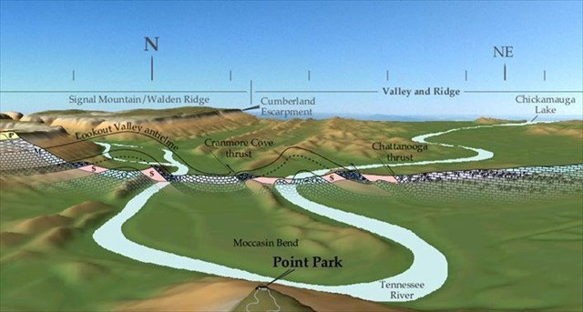
Now lets learn about some of the tectonic features responsible for creating the stresses within the rock. As seen in the image above, there are three main tectonic features found in this area, the Lookout Valley Anticline, the Cranmore Cove Thrust, and the Chattanooga Thrust. The Lookout Valley Anticline is characterized by an upward arching fold that exposes older rock layers in its core, with younger rocks on its flanks. This anticline likely formed due to compressional forces during the Appalachian orogeny, which uplifted and folded the rock layers. Next, there is the Cranmore Cove Thrust which is characterized by older rock units have been pushed up and over younger ones. This thrust fault represents a significant displacement along a fault plane. The Cranmore Cove Thrust is an example of the region's extensive thrust faulting, which played a crucial role in mountain building during the Paleozoic era. Lastly there is the Chattanooga Thrust, which is characterized by layers of rock have been thrust westward over younger strata. This thrust fault also reflects the intense compressional tectonic forces of the Appalachian orogeny, contributing to the folding, faulting, and uplift of the region.
Please remain on the trail at all times. All observations can be made from the trail.
Logging Requirements:
- Describe the joints visible in the rock in front of you. Are they systemnatic or non-systematic? Do you see any cross joints in the rock? What can these observations tell us about the types of stress that the rock forming Lookout Mountain was exposed to?
- Looking at the Tennessee River in front of you, how do you think these tectonic features influenced the path of the river? Do you think joints within the rock played a role in the formation of Moccasin Bend? Explain.
- Upload a photo taken at Point Lookout. You don't have to be in the photo, though it is strongly encouraged.
Sources:
- https://www.tn.gov/content/dam/tn/environment/geology/documents/geology_report-investigations-24.pdf
- https://www.etgs.us/trips/chattanooga/chattanooga.htm
- https://openpress.usask.ca/physicalgeology/chapter/13-3-fractures-faults-and-joints-2/
- https://collections.chattlibrary.org/s/localhistory/item/10391#lg=1&slide=0
- https://irma.nps.gov/DataStore/DownloadFile/689840