Sedimenti fluviali
Attenzione:
Siete proprio in riva al mare!
Il Sile è un fiume lungo 95 km nella regione italiana del Veneto, che sfocia nel Mare Adriatico settentrionale. Grazie all'apporto di acque sotterranee, il Sile trasporta una grande quantità di sedimenti cosiddetti fluviali, che consistono in sabbia fine con depositi organici.
Nelle geoscienze, i sedimenti fluviali, colloquialmente noti come depositi fluviali, sono la roccia frantumata trasportata da un fiume. I sedimenti trasportati dai fiumi sono di solito ben arrotondati e possono includere tutte le rocce presenti nel bacino idrografico del rispettivo fiume o torrente. Hanno granulometrie che vanno dalla sabbia fine ai massi (da 0,1 mm a circa 20 cm), a seconda della loro posizione nel tratto inferiore o superiore del corso d'acqua.
Qui, alla foce del fiume, i sedimenti sono così fini da assomigliare a una sorta di fango. Per la loro composizione, i sedimenti trasportati dal Sile sono più leggero della sabbia del mare. Per questo motivo i sedimenti fluviali più scuri vengono depositati anche sulla superficie dei sedimenti sabbiosi marini dalle maree.
(Fonte: www.wikipedia.org e propri esperimenti)
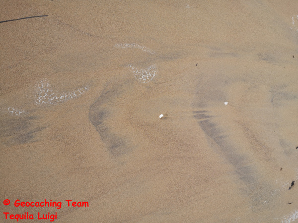
Sedimenti sulla spiaggia.
Per registrare questo EarthCache come ritrovamento, è necessario completare le seguenti operazioni.
Inviateci le risposte via e-mail o tramite un messaggio GC e registrate immediatamente!
Il nostro team vi contatterà se qualcosa non va. Vi preghiamo inoltre di comprendere che le registrazioni effettuate più di 3 settimane dopo l'invio delle risposte non possono più essere prese in considerazione a causa dello sforzo di archiviazione senza inviare nuovamente le risposte!
Passiamo ora ai compiti veri e propri:
Andate alle coordinate indicate nell'elenco. Qui troverete la spiaggia del faro di Lido di Jesolo.
1. cercate un punto in cui sia stata depositata sabbia scura e chiara.
2. prendete in mano entrambi i tipi di sabbia e tastate la granulometria: che differenza notate?
3. stimare il rapporto tra sedimenti fluviali e sedimenti marini sul posto? Cosa c'è di più qui?
4. scattate almeno una foto di voi stessi e/o del vostro GPS nel luogo in cui si trova l'EarthCache per dimostrare che eravate davvero qui. Se non volete fotografarvi, potete anche fotografare un foglio di carta con il vostro nome di geocacher e la data attuale, con qualcosa di evidente sullo sfondo, e allegarlo alla vostra registrazione. Si prega di notare che le registrazioni senza foto o con foto non conformi alle regole saranno cancellate senza alcun commento!
--------------------------------------------------------------------------------------
River Sediments
Attention:
You are right by the sea!Ihr befindet euch hier dirket am Meer!
The Sile is a 95 km long river in the Italian region of Veneto, which flows into the northern Adriatic Sea. Due to its groundwater supply, the Sile transports many so-called fluvial sediments, which consist of fine sand with organic deposits.
In the geosciences, fluviatile or fluvial (from the Latin fluvius “river”, meaning “caused by rivers”) sediments, colloquially known as river deposits, are crushed rocks carried by a river. Fluvially transported sediments are usually well-rounded and can include all rocks that occur in the catchment area of the respective river or stream. They have grain sizes ranging from fine sand to boulders (0.1 mm to around 20 cm), depending on their location in the lower or upper reaches of the watercourse.
Here at the mouth of the river, the sediments are so fine that they resemble a kind of mud. Due to their composition, the sediments carried by the Sile are lighter than the sand in the sea. This is why the darker river sediments are also deposited on the surface of the sea sand sediments by the tides.
(Source: see www.wikipedia.org & own experiments)
Sediments at the beach.
To log this EarthCache as a find, the following tasks must be completed.
Please send us the answers by e-mail or via a GC message and log immediately!
Our team will contact you if something is wrong. Please also understand that log entries that are made more than 3 weeks after the answers have been sent can no longer be taken into account without resubmitting the answers due to the storage effort!
Now to the actual tasks:
Go to the coordinates given in the listing. This is the beach at the lighthouse in Lido di Jesolo.
1. look for a place where both dark and light-colored sand has been deposited.
2. take both types of sand in your hand and feel the grain size - what difference do you notice?
3. estimate the ratio of river sediments to marine sediments on site? What is there more of here?
4. Please take at least one photo of yourself and / or your GPS at the location of the EarthCache to prove that you were really here before. If you don't want to take a photo of yourself, you can also take a photo of a piece of paper with your geocacher name and the current date, with something prominent in the background and attach it to your log entry. Please note that log entries without photos or with pictures that do not comply with the rules will be deleted without comment!
--------------------------------------------------------------------------------------
Flusssedimente
Achtung:
Ihr befindet euch hier dirket am Meer!
Der Sile ist ein 95km langer Fluss in der italienischen Region Venetien, der in die nördliche Adria mündet. Der Sile transportiert durch seine Speisung mit Grundwasser sehr viele so genannte fluviale Sedimente, welche aus feinem Sand mit organischen Ablagerungen bestehen.
Als fluviatile oder fluviale (von lateinisch fluvius „Fluss“, also etwa „von Flüssen verursachte“) Sedimente, umgangssprachlich Flussablagerung, bezeichnet man in den Geowissenschaften von einem Fließgewässer mitgeführtes zerkleinertes Gestein. Fluvial transportierte Sedimente sind meist gut gerundet und können alle Gesteine umfassen, die im Einzugsgebiet des jeweiligen Flusses oder Stromes vorkommen. Sie besitzen Korngrößen, die – je nach Lage im Unter- oder Oberlauf des Gewässers – von feinem Sand bis zu Geröll reichen (0,1 mm bis etwa 20 cm).
Hier an der Mündung des Flusses, sind die Sedimente so fein, dass sie einer Art Schlamm gleichen. Die mitgeführten Sedimente des Sile sind aufgrund Ihrer Zusammensetzung leichter als der sich im Meer befindende Sand. Deshalb werden die dunkleren Flusssedimente auch durch die Gezeiten oberflächlich auf den Meeressand Sedimenten abgelagert.
(Quelle: vgl. www.wikipedia.org & Eigene Experimente)
Sedimente am Strand
Um diesen EarthCache als Fund zu loggen, sind die nachfolgenden Aufgaben zu erledigen.
Bitte sendet uns hierfür die Antworten per E-Mail oder über eine GC-Nachricht zu und loggt sofort!
Unser Team wird sich bei euch melden, wenn etwas nicht stimmt. Bitte habt auch Verständnis dafür, dass Logeinträge, die mehr als 3 Wochen nach der Übermittlung der Antworten erfolgen, aufgrund des Speicheraufwandes, nicht mehr berücksichtigt werden können ohne erneute Übermittlung der Antworten!
Nun zu den eigentlichen Aufgaben:
Begebt euch an die im Listing angegebenen Koordinaten. Hier befindet sich der Strand am Leuchtturm von Lido di Jesolo.
1. Sucht nach einer Stelle an der sowohl dunkler als auch heller Sand abgelagert wurde.
2. Nehmt beide Sand Varianten in die Hand und fühlt die Körnung - welcher Unterschied fällt euch auf?
3. Schätzt das Mengenverhältnis vor Ort zwischen Flusssedimenten und Meeressedimenten? Wovon gibt es hier mehr?
4. Macht bitte noch mindestens ein Foto von euch und / oder eurem GPS am Ort des EarthCaches um nachzuweisen, dass ihr vor wirklich hier wart. Wer kein Foto von sich machen möchte, der kann gerne auch ein Foto von einem Zettel mit seinem Geocachernamen und dem aktuellen Datum, mit etwas vor Ort markantem im Hintergrund machen und seinem Logeintrag beifügen. Bitte beachtet, dass Logeinträge ohne Fotos oder mit nicht den Regeln entsprechenden Bildern, kommentarlos gelöscht werden!
Last change october 2024
© Team Tequila Luigi