Notice: "Cache seekers assume all risks and responsibilities involved in seeking this earthcache." “Just because it is there, doesn’t mean you have to seek the cache!” Don’t let earthcaching control you, but rather you control earthcaching.
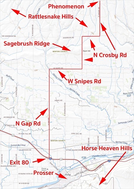
Topographical map of Rattlesnake Hills, Benton County, Washington. Courtesy of the U.S. Geological Survey, Department of the Interior/USGS (Text added).
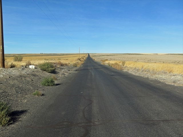
Directions: Take exit 80 off of interstate 82, turn North on N Gap Rd, turn east on W Snipes Rd, and turn north and stay on N Crosby Rd as it winds its way up to the Geological Phenomenon.
Geological Phenomenon. By definition a geological phenomenon is an observable event which is explained by or sheds light on the science of geology.
Geological Phenomena are mysterious occurrences (puzzles) in geology that scientist attempt to explain such as the Sailing Stones in Death Valley, Fairy Circles in the Namib Desert or Blood Falls of Taylor Glacier.
Those geologist who study these phenomena ask questions, make observations, collect data, analyze their findings and interpret the results to provide answers if possible. (Geology Scientific Method)
Rattlesnake Mountain and hills north of Prosser rises from the Yakima River to a height of 3,500 feet. The eastern slope overlooks the Hanford Nuclear Reservation and the western slope of the Yakima Valley. The ridge is an asymmetrical anticline pushed up from tectonic pressure within the Yakima Fold and Thrust Belt some 5-23 million years ago. A thrust fault runs along the eastern slope just below the ridge. The fault continues southeast under Red, Candy and Badger Mountains. Above 1,200 feet, the surface soil is loess (wind blow sand and silt). Below 1,200 feet, the loess overlays Missoula flood deposit of sand, gravel, and lake sediment including glacial ice rafted boulders.
Horse Heaven Hills is part of the Yakima fold and the Columbia River Basalt Group. The hills is a monoclinal fold with reverse faults. It was created from the same tectonic uplift pressure some 6-17 million years ago with the Yakima Fold Belt. The average lift from the lower Yakima Valley is 1,200 feet. The surface geology is similar to Rattlesnake Mountain.
Both formation contain Basalt from Grande Ronde, Wanapum, and Saddle Mountain.
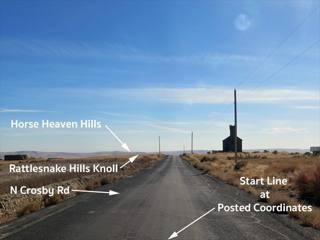
Because of nature’s randomness, a geological phenomenon was discovered on Crosby Road north of Prosser, Washington which traverses through a knoll of Rattlesnake Hills on the southern slopes of Rattlesnake Mountain. Locals call this phenomenon "Gravity Hill". Others call like geological phenomenons as Mystery Hill, Spook Hill, Magnetic Hill, or Vortex Hill.
The Question: This geological phenomenon was created because of tectonic uplifting of the Horse Heaven Hills and Rattlesnake Mountain millions of years ago and the difference in elevation between the two. At the start line (posted coordinates) the Rattlesnake Hills is at an elevation of 2,265 feet and the Horse Heaven Hills just south of Prosser is 1,850 feet, but why does Corsby RD preceive to go uphill?
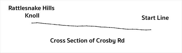
Cross Section of Crosby Rd: Perceived
Observation: When standing at the start line (posted coordinates) on Crosby Rd looking south towards Horse Heaven Hills, the road looks like it is going uphill as in the sectional view above.
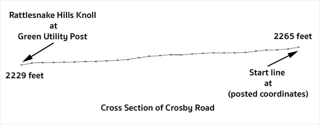
Cross Section of Crosby Rd: Actual. This cross section was drawn to scale for distance and elevation.
Data Collection: By walking from the start line to the green utility post (#12000058, near the silo), some 520 feet to the south on Crosby Road with a GPS altimeter, the road drops 36 feet in total. The road actually goes downhill over the total distance even though it feels as if a person is walking uphill.
Looking North from the green utility post.
Crosby Rd slopes uphill from the green utility post back to the start line. The preceived viewed from the start line fails. The road does go downhill from the start line.
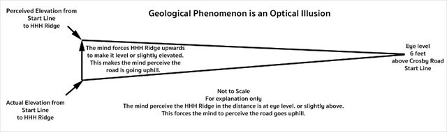
Analysis and Interpretation: When standing at the start line (posted coordinates) and looking south down Crosby Rd to the horizon, a person’s eyes focus on the north ridge of Horse Heaven Hills south of Prosser some 65,600 feet away. This ridge is 415 feet below the start line’s elevation. Looking to the HHH ridge, their eyes are looking downhill ever so slightly. The brain perception brings this drop in elevation up to level which brings the road up with making the road look like its going uphill when the road is actually not.
Other clues: If the knoll at the green utility post was really uphill from the start line, a person would not be able to see the HHH ridge in the distance, because it is not high enough. Even at the road surface, the view of HHH ridge is still visible. Also, a person of 6 feet in height standing at the start line still would not be able to see the HHH ridge over the knoll either because of the curvature of the Earth makes up for their height.
To log this earthcache: Please send me the answers to the following questions via email or the geocaching.com message center.
1. What are the four step of the Geology Scientific Method.
2. What is the structural difference between the Rattlesnake Mountain and Horse Heaven Hills?
3. How does this geological phenomenon trick your mind into believing the road goes uphill?
4. Describe your experience while visiting the site of this geological phenomenon?
Bonus question: Place your vehicle's front tires on the start line, watch for traffic, put vehicle in neutral, and let the vehicle coast to the green utility post. From the start line (posted coordinate) to the finish line (see reference point for green utility post), what was your vehicle’s velocity in terms of meters per second. (Clue: 520 feet divided by the total time traveled in seconds.)
Optional: You may upload a photo to the page of any local wildlife, unique vegetation or geology in the area.
Additional study and source:
Antigravity Hills are Visual Illusions by Bressan and Garlaschelli
How Curious: A Magnetic Hill? By Claire Donnelly
Structure and Evolution of the Horse Heaven Hills in South-Central Washington by Michael C. Hagood