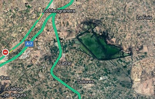
PARQUE NATURAL DE “EL HONDO”
El parque natural de El Hondo (en valenciano parc natural de El Fondo) es un espacio natural protegido
español situado entre los municipios de Crevillente y Elche, en la comarca del
Bajo Vinalopó y Catral y Dolores en la comarca de la Vega Baja del Segura.
El río Vinalopó desemboca en el azarbe de Cebadas, Sivaes o Niño, con quien se encuentra transversalmente al
este del embalse de Levante de El Hondo. Dicho canal tiene dos desembocaduras,
una en las lagunas de este parque, y otra en el mar, atravesando las Salinas de
Santa Pola y dejando al río Vinalopó sin su desembocadura original.1
Las aguas de los embalses de El Hondo (embalse de Levante y
Poniente) proceden principalmente de la desecación en 1803 de la laguna de
Villena (> 717 ha) a través de la acequia del rey, ejecutada por Carlos IV
para procurarse diezmos en beneficio de su renta, y de la desembocadura del río
Segura, siendo elevadas desde el molino harinero de San Antonio, en Guardamar
del Segura, y descendidas por gravedad mediante los aportes fluviales desde la
cuenca endorreica de la Laguna de Villena a través de la acequia del rey como
afluente del río Vinalopó, para abastecer a los regantes de la Comunidad
General de Regantes Riegos de Levante Izquierda del Segura, que es la
propietaria de los mismos.
El Hondo está incluido en el convenio internacional Ramsar de
protección de zonas húmedas y en la directiva europea Zona de Especial
Protección de las Aves (ZEPA). Protege 2387 hectáreas y fue declarado parque
natural por la Generalidad Valenciana el 12 de diciembre de 1988.

GEOGRAFIA
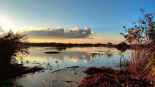
 Este parque natural está formado por múltiples lagunas, de
las cuales las dos mayores son la de Levante, de 450 hectáreas, y la de
Poniente, de 650 hectáreas, que se alimentan de las aguas del río Segura y de
los aportes fluviales encauzados por la acequia del rey al río Vinalopó,
provenientes de la gran laguna de Villena, de más de 717 ha, la cual fue
desecada por la ciudad de Elche.
Este parque natural está formado por múltiples lagunas, de
las cuales las dos mayores son la de Levante, de 450 hectáreas, y la de
Poniente, de 650 hectáreas, que se alimentan de las aguas del río Segura y de
los aportes fluviales encauzados por la acequia del rey al río Vinalopó,
provenientes de la gran laguna de Villena, de más de 717 ha, la cual fue
desecada por la ciudad de Elche.
El parque natural de El Hondo, junto con el de las Salinas de
Santa Pola y su entorno, formaba parte de la cuenca hidrográfica del Bajo
Vinalopó, que fue colmatada en el siglo XVII debido a las aportaciones
naturales y los aterramientos del pueblo de Crevillente para obtener nuevas
tierras de cultivo.
El Hondo presenta un clima mediterráneo con características
semiáridas propias del sureste de la península ibérica.
FLORA
Aunque el entorno del parque natural es bastante homogéneo,
es posible diferenciar dos tipos de ambientes en función de la profundidad y
salinidad de las aguas. En los embalses, debido al agua relativamente dulce y
con alto grado de eutrofia, apenas existe vegetación sumergida, destacando el
carrizo y el junco en las aguas poco profundas. En las charcas periféricas, por
término medio más saladas y con aguas de mejor calidad que los embalses, se
presentan diversas especies típicas del saladar endémicas del sureste
peninsular como son el limónium, la suadea o la salicornia.


FAUNA
En las lagunas existen muy variadas especies animales como
son la anguila, el mújol, el camarón de agua dulce y sobre todo el fartet, pez endémico de la región mediterránea española.


Pero sin lugar a dudas, el parque destaca por su avifauna. De
las múltiples especies existentes destacan la cerceta pardilla y la malvasía
cabeciblanca con dos de las principales poblaciones mundiales. Existe una gran
abundancia de garzas en la época de cría destacando entre todas
la garza imperial, el martinete y la garcilla cangrejera.


También es posible encontrar otras especies como la avoceta,
la cigüeñuela, la canastera, la focha moruna, el pájaro moscón o el carricerín
real. Entre las rapaces destacan el águila pescadora, el aguilucho lagunero y
el águila moteada.2 Además, cabe destacar la reaparición de la nutria aun en proceso de recuperación. Toda esta fauna perteneció
al gran entorno lagunar de Villena, tal y como dejó escrito en su "Libro
de la Caza" el príncipe don Juan Manuel de Villena en los siglos XIII-XIV,
la cual se vio obligada a emigrar de sus tierras de origen hasta Elche, tras la
desecación de la gran laguna Villenense.


ACERCA DE ESTA SERIE
Se trata de una serie de 10 caches (9 tradicionales y 1 cache
virtual), que nos llevará a realizar un recorrido circular relativamente corto,
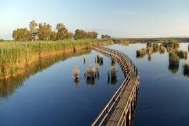
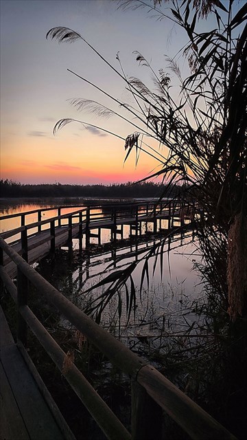
de aproximadamente 2,7 km que se inicia en el punto de acceso al Centro de
Interpretación del Parque. En un primer tramo recorreremos unas pasarelas a
través del jardín botánico que compila buena parte de las variedades flora que
podemos encontrar en el parque, internándonos después, a lo largo de otra
pasarela flotante, en los humedales mas próximos al centro de interpretación,
pasando por el Mirador del Codo, lugar al que debes acceder para poder
registrar el caché virtual.

A continuación, la serie circunvala dos de los humedales
menores siguiendo en buena medida los caminos señalizados que corren paralelos
a los azarbes o canales de riego que distribuyen el agua por las huertas
circundantes, para regresar al punto de origen.
Se trata de un recorrido de escasa dificultad, apto y
recomendable para todas las edades y forma física que, salvo que las lluvias
hayan embarrado alguno de los caminos, se realiza placida y rápidamente.
Incluso, con terreno seco, el recorrido es practicable tanto con carritos de
bebé como con sillas de ruedas para personas con movilidad reducida.
Una actividad que podemos (y debemos) complementar con la
visita al Centro de Información y museo del Parque Natural de El Hondo,
para así comprender el gran valor ambiental de estos espacios naturales,
auténticos refugios para una enorme variedad de aves, las cuales residen en
estos humedales o bien los utilizan como punto de descanso durante sus largas
migraciones entre Europa y África.

ACERCA DE LOS
CACHES
Se trata de una serie de DIEZ CONTENEDORES MIMETIZADOS que aunque no revisten excesiva dificultad, tampoco resultan
evidentes. Quien haya visitado alguna de mis series en los Parques Naturales de
Santa Pola o Las Salinas de la Mata, reconocerá fácilmente alguno de estos
contenedores (pero no todos).
ESPERO QUE DISFRUTEIS DE ESTE
MAGNIFICO PARQUE NATURAL Y DE LA SERIE!!!!

“EL HONDO” NATURAL PARK

The El Hondo Natural Park (Valencian: Parc Natural del
Fondo, Spanish: Parque Natural de El Hondo) is located within
the municipal boundaries of Elche and Crevillent both of which are within
the comarca (district) of Baix Vinalopó in the south of the
Valencian Community in the east of
Spain. Both the rivers Vinalopó and Segura discharge into the lagoons that
form this park.
The Vinalopó River
flows into the Cebadas, Sivaes or Niño rivers, with which it
meets transversally to the east
of the Levante reservoir of El Hondo. This canal has two outlets, one in the lagoons
of this park,
and another in the sea, crossing the Salinas de Santa
Pola and leaving the
Vinalopó river without its original outlet.1
The waters of the El Hondo reservoirs (Levante and Poniente reservoirs)
come mainly from the draining in 1803 of the Villena lagoon (> 717 ha) through the King's irrigation
ditch, carried out by Charles IV to obtain tithes
for his income,
and from the mouth of the
Segura river, being raised from the
flour mill of San Antonio, in Guardamar del Segura, and descended by gravity through
the river contributions from the endorheic basin
of the Villena Lagoon through the King's irrigation
ditch as a tributary of the Vinalopó river, to supply
the irrigators of the Comunidad General de Irgentes Riegos de Levante Izquierda del Segura, which is the
owner. of the same.
The park is included in the Ramsar convention list of protected
wetlands and as a Special Protection Area under the European
Union Directive on the Conservation of Wild Birds. It has an area
of 2,495 hectares and was declared a Natural Park by the Valencian
government (Generalitat Valenciana) on 12 December 1988.
TOPOGRAPHY AND CLIMATE
This natural park
is formed by a number of
lagoons, of which the two
largest are manmade and are
called Levante, which has a
surface area of 450 hectares and Poniente, with an area
of 650 hectares. These two lagoons
are fed by the waters of
the river Segura. El Fondo
and the Salinas of Santa
Pola as well as the surrounding area formed part of
the Albufera of Elche known to the
Romans as "Senus Illicitanus". The area of the
park was infilled in the 17th century due to
natural sedimentation and the
placing of silt in order to
create new areas for cultivation. At the same time the
two largest lagoons were damned
to supply water for irrigation.
The natural park
has a semi-arid Mediterranean
climate due to its location
in the south east of the
Iberian Peninsula.
FLORA
Although the parks habitats are fairly homogeneous it is possible
to distinguish two different types
of environment relating to the
depth and salinity of the water.
The reservoirs contain fresher, less saline water with a high degree
of eutrophication and therefore there is hardly any
submerged vegetation although rushes and reeds are present in the deepest waters.
The peripheral pools, are
more saline and contain better
quality water than the reservoirs
and various species typical of salt
marsh are present, such as sea lavender, shrubby seablight and glasswort.
FAUNA
Various aquatic species exist in the lagoons such
as eels, grey mullet, fresh water shrimp
and above all the Spanish toothcarp
which is endemic to the
Spanish Mediterranean region.
But without any doubt the
parks best known feature is
the bird life. The most
notable of the many species present
in the park are the marbled duck
and the white-headed duck with the
park containing two of the
largest worldwide populations. A large number of herons
are present during the breeding season
particularly the purple heron, the
night heron and the squacco heron.
It is also possible to
find other species such as the avocet, the
black-winged stilt, the collared pratincole,
the crested coot, the European
penduline tit and the moustached warbler. Birds of prey include
osprey, marsh harrier and (in winter) greater spotted eagle. An Estonia-born greater spotted
eagle wearing a transmitter has been hibernating in the park and its surroundings
each winter since
2008/2009.
ABOUT THIS SERIES
This is a
series of 10 caches (9 traditional
and 1 virtual cache), which will
take us on
a relatively short circular route,
approximately 2.7 km long, starting at the access point to
the Park's Interpretation Centre. In the first section, we will walk
along some walkways through the botanical garden
that compiles a good part of the
flora varieties that we can find in the park, then
we will go
along another floating walkway into the wetlands
closest to the interpretation centre,
passing by the Mirador del
Codo, a place that you must access
in order to register the virtual cache.
Next, the series goes around two
of the smaller
wetlands, largely following the marked
paths that run parallel to the
azarbes or irrigation channels that distribute
water through the surrounding orchards, to return
to the point
of origin.
This is a route of low
difficulty, suitable and recommended for all ages and physical
fitness levels, which, unless the rain has made some of
the paths muddy, is done smoothly and quickly. Even on dry
ground, the route is suitable
for both baby strollers and wheelchairs for people with
reduced mobility.
An activity that we can (and should) complement with a visit to
the Information Centre and museum of the
El Hondo Natural Park, in order to
understand the great environmental value of these
natural spaces, authentic refuges for a huge
variety of birds, which reside in these wetlands or use them as a resting point during
their long migrations between Europe and Africa.
ABOUT THE
CACHES
This is a
series of TEN CAMOUFLAGED CONTAINERS that, although they are not excessively
difficult, are not obvious either. Anyone who has visited one of
my series in the Natural
Parks of Santa Pola or Las
Salinas de la Mata, will easily
recognise some of these containers
(but not all).
I HOPE YOU ENJOY THIS MAGNIFICENT
NATURAL PARK AND THE SERIES!!!!