Mont Valérien
Butte-témoin - Outlier hill
 Le mont Valérien est une colline située à l’ouest de Paris et qui culmine à 161 mètres d’altitude. Si dans le passé un calvaire avait été érigé à son somment, c’est une forteresse militaire qui le remplace maintenant depuis 1841.
Dans le domaine de la géologie, cette colline est considérée comme étant une butte-témoin. Au travers de cette cache, nous vous proposons de découvrir comment elle s’est formée et de venir admirer la vue qu’elle offre sur les alentours.
 Mont Valérien is a hill in western Paris that rises to a height of 161 meters. While a calvary once stood at its summit, since 1841 it has been replaced by a military fortress.
In the field of geology, this hill is considered to be a outlier hill. Through this cache, we invite you to discover how it was formed and come enjoy the view it offers of the surrounding area.
Pour valider la cache - Logging requirements
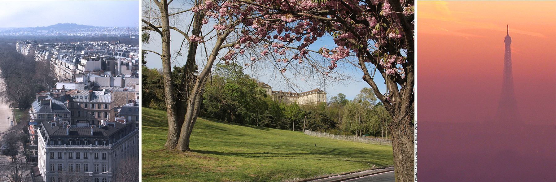
Aux coordonnées indiquée, vous serez situé square du général Ferrié et plus précisément sur un belvédère qui offre un vue sur les environs et en partie sur Paris.
Travail à effectuer
- À l’aide de l’altimètre intégré à votre GPS ou à l’aide d’une application à que vous aurez installée sur votre téléphone, mesurez l’altitude à laquelle vous vous trouvez. En vous référant au croquis donné en description, quel serait la roche sous vos pieds si elle n’était pas recouverte par le revêtement actuel ?
- En balayant du regard la vue qui s’offre à vous, remarquez-vous une autre butte-témoin ? Si vous ne connaissez pas son nom, quel élément emblématique est situé à son sommet ?
- Une photo de vous, ou d’un objet caractéristique vous appartenant, prise dans les environs immédiats (pas de photo « d’archive » svp) est à joindre soit en commentaire, soit avec vos réponses. Conformément aux directives mises à jour par GC HQ et publiées en juin 2019, des photos peuvent être exigées pour la validation d’une earthcache.
Marquez cette cache « Trouvée » et envoyez-nous vos propositions de réponse. Nous vous répondrons si besoin.
- - -
At the specified coordinate, you will be at Square du Général Ferrié, more precisely at a lookout point with views of the surrounding area and part of Paris.
Homework
- Using the altimeter integrated into your GPS or an app installed on your phone, measure your current altitude. Referring to the sketch provided in the description, what would be the rock beneath your feet if it were not covered by the current covering?
- Looking out over the view before you, do you spot another outlier hill? If you don't know its name, what iconic structure can be found at its summit?
- A picture of you, your GPS/cellphone or something else personnal, taken in the immediate aera (no "stock" photos please) is to be attached either as a comment or with your answers. In accordance with updated GC HQ guidelines published in June 2019, photos may be required for validation of an earthcache.
Log this cache "Found it" and send us your answer suggestions. We'll get back to you.
Quelques concepts / Few concepts
Butte-témoin
- Butte-témoin, butte-témoin ! Témoin d’qui, d’quoi ? Témoin oculaire ? Témoin de Jehovah ? T’es moins que rien ?
- Naaan, il s’agit d’une butte qui témoigne de la constitution du sous-sol des environs il y a un certain temps, un temps certain même.
- Ah bon, parce que l’coin a changé ? Ch’ais bien qu’il y avait les parisis, les gaulois et les romains par ici, faut remonter à plus loin qu’ça ?
- Oui, à des millions d’années.
- Des millions d’années ! Au temps de dinosaures ?
- Non, plus vieux que ça. Il y a 245 millions d’années, une mer peu profonde et calme occupait une très grande surface du Massif Armoricain à l’ouest, aux Vosges à l’est, bordée par le Massif central au Sud. Cela ressemblait à immense bassin. Bassin parisien, ça te dit quelque chose ?
- Ouais, j’ai appris ça à l’école, au primaire. Ah c’est çaaa l’rappooort, Bassin parisien, pask’à l’époque l’coin était un bassin géant rempli d’eau.
- Exactement et au cours du temps, il y a eu ce qu’on appelle des régressions, la mer se retire entièrement ou en partie, et des transgressions, elle revient. L’amplitude des va-et-vient de l’eau était variable. Pendant tout ce temps, il y a un tas de trucs qui sont tombés au fond de l’eau : des animaux marins morts (bivalves, gastéropodes), sable, limon, … des produit d’érosion des massifs cités précédemment. Je peux t’en donner les détails, mais j’imagine que ton temps est limité, non ?
- Ben oui, j’ai bientôt piscine. Mais si tout ça gisait au fond d’l’eau, elle est passée où toute cette flotte ?
- Elle a disparu pour plusieurs raisons dont la principale est liée aux mouvements tectoniques. Les Alpes, tu connais ?
- Ben ouais, j’y vais pour faire du ski.
- Pour simplifier, lorsque les Alpes sont sorties de terre, par ce qu’on appelle une orogenèse, elles ont fait basculer le bord du bassin en coupant les communications avec les mers voisines. De plus le niveau général de océan a baissé. L’eau a commencé à se retirer et des fleuves en formation ont drainé le coin. Des accumulations supplémentaires (alluvions, dépôts fluviatiles) ont comblé le bassin.
- T’as eu raison de simplifier, mais ça explique pas le fait qu’on s’trouve sur une butte. J’pense plutôt qu’on est sur le dos d’un volcan sous-marin
- Il n’y a jamais eu de volcanisme par ici. Si nous sommes ici sur une butte, c’est parce que tout ce qui était autour de cette butte a été érodé.
- Mais pour quelle raison elle n’a pas été érodée ta butte ?
- Ce n’est pas ma butte, mais c’est une bonne question.
- Ah ha, j’t’ai coincé là, hein ?
- Les derniers sédiments déposés se sont transformés en roches très dures, comme certains calcaires ou des grès. Ces roches très dures ont protégée en quelque sorte les roches sous-jacentes plus tendres et donc plus fragiles. La Seine et ses affluents ont entaillé toutes ces couches/roches sédimentaires - y compris les roches dures - en créant des reliefs. Quelques fois un cours d’eau peut être détourné et en laissant derrière lui ces reliefs pour en créer ailleurs. L’érosion générale du Bassin (pluie, ruissellement, gel-dégel) affaiblit les couches tendres. Toutes ces couches disparaissent et sont emportées par l’eau. Il reste des buttes épargnées.
- Ça n’a pas dû s’faire en 15 jours ?
- Eh bien non, faut vraiment du temps. Ci-dessous un croquis de la butte du Mont Valérien avec la constitution de son sous-sol représentative de ce qu’il y avait ailleurs. Tout en haut, les roches les plus récentes et qui correspondent au derniers dépôts avant que le bassin ne soit vidé de son eau. Tout en bas, les roches les plus vielles. En dessous de ces dernières mais non représentées, il y en a sur 3 000 mètres !
- Ah la vache ! Du coup, si j’prends ma pelle et mon sceau et que si j’creuse çà et là, j’peux tomber sur une de ces roches, c’est ça ?
- Euh oui, mais t’auras du mal. Sur tout ce qui n’a pas été bétonné ou construit, il y a un sol d’une épaisseur d’un à deux mètres et dont la formation est beaucoup plus récente. Il doit d’abord être dégagé et il te faudra pour cela plutôt une pelle mécanique. Je ne pense pas qu’une autorisation pour faire ce genre de travaux ne te soit accordée.
- J’m’en doutais, mais j’voulais juste être sûr.
- Eh bien voilà, je t'ai rassuré, tu peux aller sereinement à ta piscine et tache de ne pas tomber au fond du bassin.
- Ah, très drôle.

Texte, photos et croquis : Loulousoleil
Outlier hill
“Outlier hill? Outlier of what? Statistics? Did the hill fail math class? Is it the rebel of the landscape?“
”Noooo, also called erosional outlier hill or butte, it's a mound that shows what the subsoil in the area was like a long time ago, a very long time ago.”
”Really, because the area has changed? I know there were Parisii, Gauls, and Romans around here, but does it go back further than that?”
”Yes, millions of years.”
”Millions of years! Back in the time of the dinosaurs?”
”No, even older than that. 245 million years ago, a shallow, calm sea covered a huge area from the Armorican Massif in the west to the Vosges in the east, bordered by the Massif Central to the south. It was like a huge basin. Does the Paris Basin ring a bell?”
”Yeah, I learned that in elementary school. Oh, that’s the connection!, Paris Basin, because at the time the area was a giant basin filled with water.”
”Exactly, and over time, there were what are called regressions, when the sea receded entirely or partially, and transgressions, when it returned. The amplitude of the water's ebb and flow varied. During all this time, a lot of stuff fell to the bottom of the water: dead marine animals (bivalves, gastropods), sand, silt, etc., products of erosion from the mountain ranges mentioned earlier. I can give you the details, but I imagine your time is limited, right?”
”Yeah, I'll be at the *swimming pool soon. But if all that stuff was lying at the bottom of the water, where did all that water go?”
”It disappeared for several reasons, the main one being related to tectonic movements. Do you know the Alps?”
”Yeah, I go there to ski.”
”To put it simply, when the Alps rose up from the earth through a process called orogenesis, they tilted the edge of the basin, cutting off communication with surrounding seas. In addition, the overall sea level dropped. The water began to recede and rivers in formation drained the area. Additional accumulations (alluvium, fluvial deposits) filled the basin.”
”Well, that’s one way to put it but it doesn't explain why we're on a hill. I think we're on the back of an underwater volcano.”
”There has never been any volcanic activity around here. If we're on a hill, it's because everything around it has been eroded away.”
”But why hasn't your hill been eroded?”
”It's not my hill, but it's a good question.”
”Ha! Caught you!”
”The last sediments deposited turned into very hard rocks, such as specific limestone or sandstone. These very hard rocks protected the softer and therefore more fragile underlying rocks. The Seine and its tributaries carved through all these sedimentary layers/rocks—including the hard rocks—creating relief. Sometimes a river can be diverted, leaving behind these relief features and creating new ones elsewhere. General erosion of the basin (rain, runoff, freeze-thaw cycles) weakens the soft layers. All these layers disappear and are carried away by the water. What remains are the spared hills.”
”That couldn't have happened in two weeks, could it?”
”No, it really takes time. Above is a sketch of the Mont Valérien outlier hill with its subsoil composition representative of what was found elsewhere. At the top are the most recent rocks, corresponding to the last deposits before the basin was emptied of its water. At the bottom are the oldest rocks. Below these, but not shown, there are 3,000 meters of rock!”
”Wow! So if I take my shovel and bucket and dig here and there, I might come across one of these rocks, right?”
”Yes, but it will be difficult. On top of everything that hasn't been concreted or built on, there is a layer of soil one to two meters thick, which is much more recent in formation. It would first have to be cleared, and for that you would need a mechanical shovel. I don't think you would be granted permission to do that kind of work.”
”I figured as much, but I just wanted to be sure.”
”Well, there you go, you can relax now and go to the pool without any worries, but try not to fall at the bottom of the basin.”
”Ha, ha, very funny.”
*Popular French expression used as an excuse.
Text, pictures and sketch: Loulousoleil