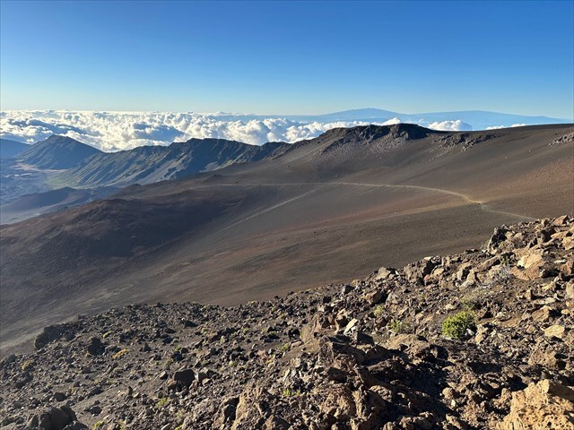
Haleakalā National Park stretches from the summit of its massive shield volcano down to the coastal rainforests of Kīpahulu on Maui’s eastern shore. The park is home to a wide range of ecosystems, from barren volcanic slopes to lush tropical forests, and protects habitats for native species found nowhere else. It also preserves important cultural sites that reflect the deep history and traditions of the Hawaiian people. Keonehe‘ehe‘e, or Sliding Sands, descends from the summit area of Haleakalā into the crater and offers expansive views of colorful ash deposits, scattered lava formations, and the rugged interior of the volcano.
There are three types of volcanic eruptions and each produces distinct deposits that reveal clues about the eruption’s energy, the involvement of water, and the nature of the magma. Understanding these differences helps geologists reconstruct volcanic history and assess future hazards.
- Magmatic eruptions – Driven purely by the expansion of gases within rising magma, these eruptions produce fresh volcanic material such as lava flows, scoria and pumice, and volcanic ash. Deposits often contain vesicular fragments (meaning they contain gas bubbles), volcanic glass, and crystals. Colors can range from black to red to gray depending on oxidation (rust), and you may see lava structures like pāhoehoe, ʻāʻā, or spatter cones.
- Phreatic eruptions – Steam driven blasts caused when groundwater or surface water is superheated by magma or hot rock. They do not bring new magma to the surface, instead they shatter and eject existing rock. Deposits are typically fine grained, blocky, and composed of angular fragments of preexisting material, sometimes showing hydrothermal alteration (yellow sulfur deposits, white clay-rich patches).
- Phreatomagmatic eruptions – Caused by direct interaction between magma and water, these eruptions fragment magma more efficiently than magmatic ones and produce very fine ash and abundant angular particles. Deposits may be well layered, with features like base surges (fast moving flow of volcanic material formed at base of eruption column), cross bedding (angled layers within rock), and accretionary lapilli (small, spherical ash pellets). The material is usually less vesicular than pure magmatic deposits due to rapid cooling and quenching.
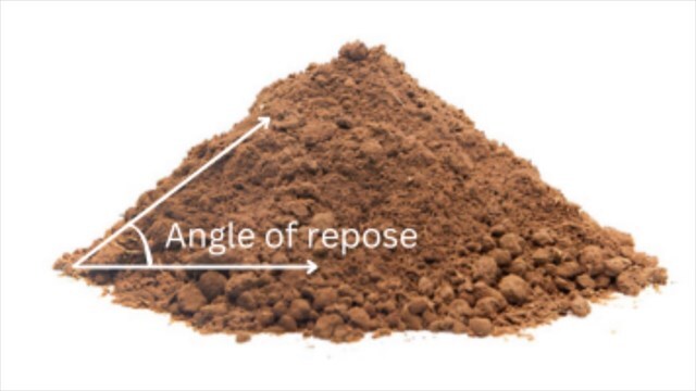
The angle of repose is the steepest slope at which loose, unconsolidated material can remain stable without sliding downslope. It is determined by the balance between gravity pulling the material downward and the frictional (and interlocking) forces that hold the particles in place. In geology, it helps explain why certain landforms such as talus slopes, cinder cones, and sediment piles naturally form at specific inclinations. Because it can be measured directly in the field, it serves as a practical way to connect the physical properties of loose material with the shapes of the landscapes they create.
There are several factors influence the angle of repose. Grain size plays a role, with coarser particles often forming steeper slopes than fine particles. Grain shape is also important, since angular, blocky fragments interlock more effectively than rounded grains which increases stability. Sorting also plays a factor since well-sorted materials behave differently from poorly sorted ones, with uniform grain sizes often having a narrower range of angles. Moisture content can also either increase cohesion in small amounts which allows steeper slopes, or reduce stability when saturation leads to lubrication between particles.
Please be aware that cell service is spotty within Haleakalā National Park. Also in order to help protect the site for future generations to enjoy, please remain on the trail at all times.
Logging Requirements:
- Describe the physical characteristics of the volcanic material in the area. Based on your observations, what type of eruption do you think took place here? Explain.
- Estimate the angle of repose of the volcano. How would you describe the shape, sorting, and moisture content of the material? The average angle of repose for cinders is about 33 degrees, how does this compare?
- Upload a photo with either yourself or a personal object taken near the listed coordinates.
Sources:
- https://npshistory.com/publications/hale/nrr-2011-453.pdf
- https://www.nps.gov/hale/planyourvisit/hiking.htm
- https://en.wikipedia.org/wiki/Volcanic_eruption
- https://www.google.com/search?client=safari&rls=en&q=frixtion+angle&ie=UTF-8&oe=UTF-8
- https://en.wikipedia.org/wiki/Angle_of_repose
- https://structx.com/Soil_Properties_005.html