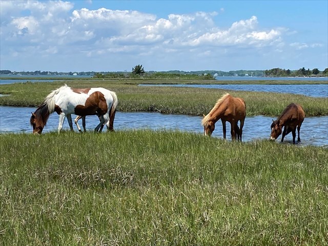
Assateague Island National Seashore is a barrier island located along the Maryland and Virginia coast. Established in 1965, the seashore preserves more than 37 miles of undeveloped shoreline, where winds, tides, and storms continuously reshape the land. Its beaches, salt marshes, and dunes provide habitat for a wide range of species, including the famous wild horses that roam freely across the island.
Salt marshes are coastal wetlands that form in sheltered areas where tides regularly flood and drain the land. They are dominated by salt tolerant grasses and plants, which help trap sediments and build up the marsh over time. Salt marshes are important because they help absorb wave energy and reduce coastal erosion. The marsh vegetation slows incoming waves, with the stems and roots generating friction and dissipating much of the wave energy before it reaches the shoreline. At the same time the marsh surface acts like a sponge, helping soak up excess water and reducing the impact of storm surges.
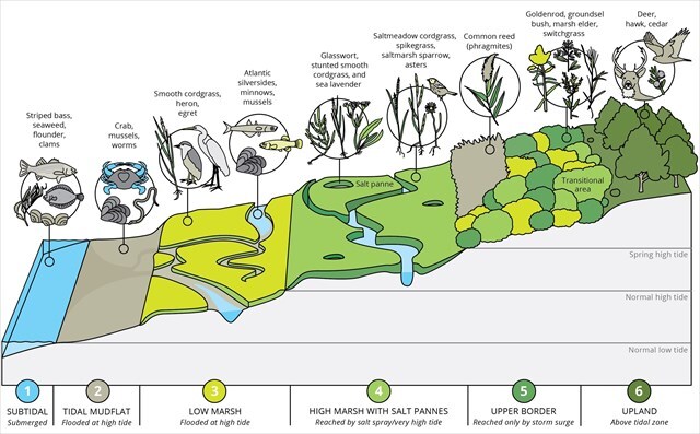
Salt marshes are divided into five zones, based on how often they are flooded and the role they play in the coastal ecosystem:
- Subtidal zone: Permanently submerged, this is where tidal currents and wave action continuously move and deposit sediments. It forms the foundation for the development and stability of the entire salt marsh system.
- Tidal mudflats: Exposed at low tide, these flat, muddy areas act as sediment traps where fine particles settle out of the water. This helps build up the marsh surface and creates the conditions for new marsh vegetation to take root.
- Low marsh: Regularly flooded, this zone is dominated by dense salt tolerant grasses that stabilize sediments, reduce wave energy, and gradually build up the marsh platform.
- High marsh: Flooded only during the highest tides, this zone is slightly higher in elevation. It supports a mix of salt-tolerant grasses and succulent plants.
- Upper border: Rarely flooded, this edge marks the transition to upland areas. It helps buffer the marsh from human activity and upland runoff, protecting the lower marsh zones.
You can tell whether a salt marsh is growing or shrinking by looking at its shoreline, vegetation, and flooding patterns. If the shoreline appears irregular, undercut, or eroded, it may indicate that the salt marsh is shrinking. In contrast, a stable, intact edge suggests the marsh is holding its ground, and possibly even expanding. Vegetation also provides important clues, since healthy dense plants suggest a stable or growing marsh, while large patches of dying plants can signal erosion or stress. Flooding frequency is another key indicator, since a marsh that is submerged more often than usual may be sinking or struggling to keep pace with rising water levels.
Logging Requirements:
- What is the tide at the time of your visit? Based on your observations, what zone of the salt marsh are you looking at? Explain.
- Does it look like the salt marsh is expanding, shrinking, or remaining stable in size? Why do you think this might be the case? Explain.
- Upload a photo with either yourself or a personal object, along the Life on the Marsh Trail.
Sources:
- https://irma.nps.gov/DataStore/DownloadFile/482243
- https://oceanservice.noaa.gov/facts/saltmarsh.html
- https://en.wikipedia.org/wiki/Salt_marsh