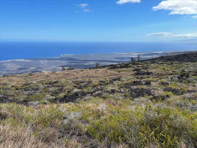
Kealakomo Overlook offers a glimpse at Kīlauea’s lava flows and the surrounding volcanic landscape. The overlook offers a panoramic view of the Pacific Ocean and the vast lava field that covers the site of the ancient village of Kealakomo. The village was likely destroyed and abandoned after the 1868 earthquake and tsunami, then buried by the Maunaulu lava flows from 1969 to 1974, which created about 210 acres of new land.
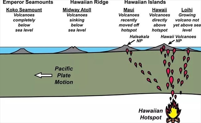
The Hawaiian Islands and their underwater extensions formed as the Pacific Plate moved over a stationary volcanic hotspot. As the Pacific Plate slowly moves northwest over the stationary hotspot, magma rises through the crust and erupts to form new volcanoes. Over time, repeated eruptions build these volcanoes high enough to emerge above sea level, which creates islands, while older volcanoes are carried away from the hotspot and gradually erode or submerge. The Emperor Seamount Chain, the Hawaiian Ridge, and the Hawaiian Islands represent a chronological sequence of volcanic activity over the Hawaiian hotspot. The oldest is the Emperor Seamounts, which lies farthest northwest and consist of mostly submerged, ancient volcanoes formed over the hotspot tens of millions of years ago. Moving southeast, the Hawaiian Ridge is a chain of older, partially submerged volcanoes that were once islands but have eroded over time. The youngest features are the Hawaiian Islands, including the Big Island, which sits directly above the hotspot and hosts active volcanoes like Kīlauea and Mauna Loa.
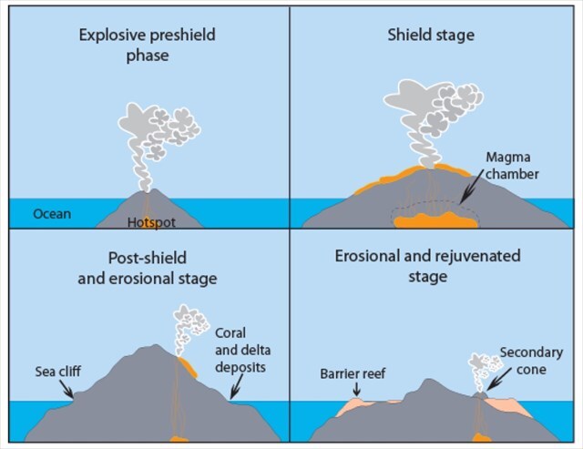
The Hawaiian hotspot produces islands through a sequence of volcanic growth and decay as the Pacific Plate moves over the plume. Geologists generally divide the life cycle of a Hawaiian volcano into four main stages:
- Preshield stage: This begins underwater, where scattered eruptions of alkalic basalt slowly build a seamount that has not yet reached the ocean surface.
- Shield stage: Frequent eruptions of tholeiitic basalt construct most of the volcanic mass and give the volcano its broad shield shape above sea level.
- Post-shield stage: Eruptions become less frequent, shift back to alkalic compositions, and produce localized vents and steeper cones.
- Erosional and rejuvenated stage: Weathering, stream incision, and landslides reshape the island, coral reefs may form around its edges, and in some cases smaller rejuvenated eruptions of alkalic lava occur after long dormancy.
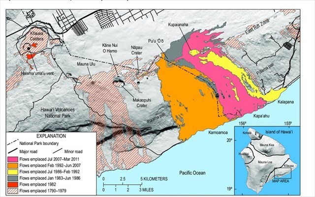
Kīlauea has a long history of eruptions, which ranged from small lava flows to events that dramatically reshaped the island. The map above shows several of the major volcanic events that have altered the landscape in this area. The 1790 eruption was explosive and deadly, producing ash and volcanic debris that affected nearby villages. In 1924, Kīlauea produced a brief explosive eruption that sent lava fountains and ash clouds into the air. More recently, the 1969–1974 Maunaulu eruption created hundreds of acres of new land, covering parts of the southeastern coast. The 2018 eruption was particularly destructive, producing lava flows that destroyed homes and reshaped communities, including large sections of Leilani Estates.
Please remain on the trail at all times in order to help protect the site for future generations.
Logging Requirements:
- Looking around, describe the volcanic landscape visible. Based on your observations, which stage of volcanic activity is Kilauea in? Explain.
- How do you think the volcanic landscape in this area will change over time? Looking at the map, most of the orange, yellow, magenta, and green flows overlap along the East Rift Zone and Kīlauea. Based on this, do you see any sort of pattern, and which area do you think the next major eruption will occur?
- Upload a photo with either yourself or a personal object taken at the Kealakomo Overlook.
Sources:
- https://irma.nps.gov/DataStore/DownloadFile/425531
- https://volcanoes.usgs.gov/observatories/hvo/hawaiian_volcanoes.html
- https://www.nps.gov/subjects/geology/plate-tectonics-oceanic-hotspots.htm
- https://www.soest.hawaii.edu/GG/FACULTY/KJOHNSON/GG103/lectures/Hawaii_evolution.pdf
- https://www.nps.gov/places/kealakomo-overlook.htm