
이 어스캐시의 학습 포인트는 타포니를 더 잘 이해하는 것입니다.
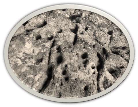
목표 지점(GZ)에서는 구멍이 뚫린 벽, “상처”가 난 벽, 그리고 타포니라는 이름으로 알려진 지층 붕괴 현상을 관찰할 수 있습니다. 이 구멍들과 돌의 일부가 다소 고르지 않고 크기와 깊이가 다르다는 것을 알게 될 것입니다. 아래 텍스트를 읽으면 이 현상이 무엇인지 알게 될 것입니다. 이곳 현장에서 관찰할 내용을 바탕으로 여러분이 보는 것을 잘 설명해 줍니다. 아래 질문에 답할 수 있도록 돌을 자세히 살펴보세요.
타포니
타포니는 작은 동굴, 붕괴, “상처”, 형상 결함을 닮은 지질 구조로, 둥근 입구와 매끄럽고 오목한 벽을 지닙니다. 일반적으로 1cm 미만의 작은 것부터 1m 이상의 큰 것까지 자연 또는 인공 구조물에서 발달하는 공동 특징으로 정의됩니다. 타포니는 절벽, 언덕, 암석 지대에서 흔히 발견됩니다. 주로 화강암, 사암 또는 모래질 석회암에서 형성되며 반건조에서 건조한 사막 기후에서 특히 흔합니다. 벌집 모양 또는 “버섯 모양”의 외관으로 인해 이 지형은 쉽게 알아볼 수 있습니다.
타포니의 형성은 일반적으로 동결-해동, 습윤-건조 및 염분 풍화 등의 원인으로 이루어집니다. 염분 풍화의 한 형태인 벌집형 풍화가 가장 흔한 설명입니다. 이는 투과성 암석 표면에 염분이 축적될 때 발생하며, 주로 해수, 안개 또는 바람에 의해 발생합니다. 염분이 함유된 물이 증발하면 염분이 남게 됩니다. 염분은 암석의 기공 속으로 침투하여 결정화되면서 기공을 더욱 넓게 벌립니다. 이렇게 확대된 암석 기공은 앞서 언급한 습윤-건조 및 동결-해동 주기를 포함한 추가 풍화 작용을 받습니다. 상당한 시간이 지나면 이러한 풍화 작용이 타포니 형태로 눈에 띄게 나타납니다.
해안 지역에서 타포니가 발생하는 현상을 설명하는 다른 이론들도 존재합니다. 염분 풍화 외에도 연체동물 및 기타 해양 생물이 타포니 형성을 촉진할 수 있다고 여겨집니다. 이들은 바위 해안선에 작은 구멍을 뚫고 그곳에 부착하여 광물을 추출합니다. 시간이 지남에 따라 구멍은 점점 커지다가 결국 연체동물이나 다른 생물이 떨어져 나갑니다. 이후 구멍은 바람, 비, 조류와 같은 자연 요소에 노출됩니다. 이러한 요소들이 함께 작용하여 타포니 지형을 형성합니다.
타포니의 기원에 대해서는 여러 가지 설명이 제시되어 왔다. 여기에는 해양 침식, 풍화 작용, 단기 온도 변화에 의한 기계적 풍화, 보호 피막(표면 경화) 아래 암석 내부(핵부 연화)의 화학적 풍화 후 연화된 물질의 기계적 제거, 이끼의 생지화학적 풍화, 해안 지역의 염분 결정화에 영향을 미치는 온도 변화, 염분 풍화 등이 포함된다. 최근 지질학자와 연구자들은 타포니 형성의 주요 원인으로 염분 풍화를 주장해 왔다. 현재 타포니아는 다원적 기원을 가진 것으로 간주되며, 염분 풍화와 주기적 습윤-건조 현상을 포함한 물리적·화학적 풍화 과정 간의 복잡한 상호작용의 결과로 여겨진다.
풍화란 암석, 광물, 토양 및 기타 물질이 공기, 물(얼음), 온도 변화 및 생물체와의 직접적인 접촉에 의해 분해되는 현상이다. 풍화는 침식과 함께 지형을 형성한다.
풍화와 침식의 주요 차이점은 과정이 일어나는 장소에 있다. 풍화는 암석을 제자리에서 부스러뜨리는 반면, 침식 작용은 느슨해진 물질을 제거한다. 풍화 강도에 영향을 미치는 중요한 요인으로는 암석의 종류, 기후, 지질 구조 환경이 있다.
풍화는 분해 산물의 이동이 거의 없거나 전혀 없는 현장에서 발생합니다. 일반적으로 기계적 풍화와 화학적 풍화를 구분하지만, 둘 다 생물학적 요소를 포함할 수 있으며 따라서 생물학적 풍화는 세 번째 주요 유형으로 간주될 수 있습니다. 기계적 풍화와 화학적 풍화는 동시에 발생하여 서로를 강화할 수 있습니다. 추위와 건조함 또는 더위와 습기 같은 극한 환경에서는 한 가지 주요 유형이 우세해지는 경향이 있습니다.
반면 침식은 물질을 갈거나 분해하고, 이 분해 산물인 느슨한 물질을 운반하는 과정이다. 침식은 흐르는 물, 파도, 바람, 눈, 얼음 또는 중력과 같은 다양한 작용인자(즉, 과정을 주도하거나 유지하는 요소)의 도움으로 발생한다. 분해 산물은 하나 이상의 작용인자에 의해 운반되므로 원천 지역으로부터 다양한 거리에 퇴적될 수 있다.
기계적 풍화
기계적 풍화는 화학적 변화 없이 암석이 순수하게 부서지는 현상이다. 온도와 압력의 변화는 균열을 일으키고, 시간이 지남에 따라 지표면이 부서지게 한다. 기계적 풍화는 파편이나 입자 크기의 감소를 초래하며, 추운 건조한 환경에서 주로 발생한다.
한 예로 서리 풍화 현상인 서리 분사가 있습니다. 또 다른 예로는 주야간 온도 차이가 큰 지역에서 발생하는 박리 및 균열 현상이 있습니다. 암석 표면이 내부보다 더 강하게 가열되면서 발생하는 응력이 균열을 유발합니다.
화학적 풍화
화학적 풍화는 특히 물(빗물 및 지하수)의 용해 효과와 관련이 있으며, 산성수가 가장 효과적입니다. 화학적 풍화는 암석 표면 근처의 성분을 변화시킵니다. 암석 내 특정 물질(예: 나트륨 화합물)은 매우 쉽게 용해되는 반면, 다른 물질은 변하지 않습니다. 모든 화학적 과정과 마찬가지로 화학적 풍화는 낮은 온도보다 높은 온도에서 더 빠르게 진행되며, 따라서 덥고 습한 열대 지역에서 더 두드러집니다. 식생도 유기산을 공급하기 때문에 중요한 역할을 합니다.
화학적 풍화의 예로는 녹(鏽) 형성이 있습니다. 암석 내 철 함유 화합물은 물과 공기와 반응하여 적갈색의 산화철이 생성됩니다.
이 캐시를 기록하려면.
이 캐시를 기록하려면 지오캐시에 제공된 좌표와 관련된 질문들을 방문하여 답변해야 합니다.
답변을 수집한 후, 확인을 위해 CO에게 보내주십시오.
답변을 CO에게 보낸 직후 기록할 수 있습니다. 답변에 대해 질문이 있을 경우 CO가 연락할 것입니다.
CO에게 답변을 제출하지 않았거나 CO의 미해결 질문이 있는 로그는 별도의 통보 없이 삭제됩니다.
질문에 대한 답이 될 수 있는 사진을 로그에 포함하지 마십시오.
질문:
1. 아래 질문에 대한 답변을 좌표를 방문하여 작성하십시오.
A. GZ의 타포니를 관찰하고 연구하십시오! 타포니의 평균 직경과 깊이를 mm 단위로 추정하십시오!
B. 해당 지역 중 타포니가 차지하는 비율은 얼마이며, 타포니가 감소하고 영향을 받지 않은 부분으로 넘어가는 원인을 설명하십시오.
C. GZ에서 관찰 및 연구한 내용을 바탕으로, 구멍이 발생한 풍화 과정과 반응을 설명하세요. 여기에 침식이 포함되었나요? 자신의 말로 설명하세요!
2. 답변 내용이 노출되지 않도록 해당 위치에서 본인, 그룹 또는 GPS 사진을 촬영하세요.
The learning point with this earthcache is to get to know tafoni better,
At GZ, you will be able to observe a holey wall, wall with "wounds" and formation failure which consists of what goes under the name tafoni. You will find that these holes and parts of the stone are somewhat uneven, of different sizes and depths. You will find out what this phenomenon is about by reading through the text below, which gives you a good description of what you see based on what you will be studying here at the location. Keep a close eye on the stone to be able to answer the questions below.
Tafoni
Tafoni is a geological formation that resembles a small cave, cave-in, "wound", formation failure, with a round entrance and smooth, concave walls. Generally defined as small less than 1 cm to large, greater than 1 meter cavity features that develop in either natural or man-made works. Tafoni is often found in cliff sides, hills and rocky areas. Tafoni is most commonly formed in granite, sandstone or sandy limestone and is particularly common in semi-arid to arid desert climates. This formation is easy to recognize because of its honeycomb or "mushroom-like" appearance.
The formation of tafoni typically consists of causes such as freezing-thawing, moisture-drying and salt weathering. Honeycomb weathering, a form of salt weathering, is the most common explanation. It occurs when salt accumulates on the surface of permeable rocks, usually by ocean waves, fog or wind. When the salt water evaporates, it leaves the salt behind. The salt works its way into the stone pores, where it crystallizes and pushes the pores open further. These enlarged rock pores are subjected to further weathering, including the aforementioned wetting-drying and freeze-thaw cycles. After a considerable time, the weathering becomes noticeable in the form of tafoni.
There are other theories that explain the presence of tafoni in coastal areas. It is believed that in addition to salt weathering, molluscs and other marine life can also initiate tafoni. They do this by making small holes in the rocky coastlines, where they attach themselves and extract minerals. The hole grows larger over time until eventually the mollusk, or another organism, falls off. The hole is then left to the elements, such as wind, rain and tides. These work together to create the tafoni formations.
Many explanations have been proposed for the origin of taphoney. They include marine wear; wind corrosion; mechanical weathering as a result of short-term temperature variations; chemical weathering of the interior of the rock (core softening) under a protective crust (case-hardening) followed by mechanical removal of the softened material; biogeochemical weathering of lichens; temperature variations affecting salt efflorescence in coastal areas; and salt weathering. In recent times, geologists and researchers have advocated salt weathering as the primary explanation for the formation of tafoni. Currently, tafonia is considered to be polygenetic in origin, and is the result of complex interaction between physical and chemical weathering processes, which include salt weathering and cyclic wetting and drying.
Weathering is the breakdown of rocks, minerals, soil and other materials by direct contact with air, water (ice), temperature fluctuations and biological organisms. Weathering shapes the landscape together with erosion.
The main difference between weathering and erosion is where the process takes place. As weathering crumbles the rocks in place, the erosive forces remove the loose material. Important factors that affect the intensity of weathering are the type of rock, climate and tectonic setting.
Weathering takes place in situ with little or no movement of the decomposition products. It is common to distinguish between mechanical and chemical weathering, but both can have a biological component, and biological weathering can therefore be considered a third main type. Mechanical and chemical weathering can take place simultaneously and thus reinforce each other. In more extreme environments, such as cold and dry or hot and humid, one main type will tend to dominate.
Erosion, on the other hand, is a process that grinds or breaks down material and also transports the loose material, i.e. the breakdown products. Erosion occurs with the help of various agents (i.e. what drives or maintains a process), such as running water, waves, wind, snow, ice or gravity. The decomposition products are transported by one or more agents and can therefore be deposited at varying distances from the source area.
Mechanical weathering
Mechanical weathering is a pure crumbling of the rocks without chemical changes. Changes in temperature and pressure can lead to cracking and, over time, crumbling of the land surface. Mechanical weathering leads to a reduction in clast or particle size, and tends to dominate in cold and dry environments.
An example is frost blasting, which is a type of frost weathering. Another example is peeling and cracking in areas where there are large temperature differences between day and night. The surface of the rock is heated more strongly than the interior, and tensions arise that lead to cracking.
Chemical weathering
Chemical weathering is particularly linked to the dissolving effect of water (rainwater and groundwater), where acidic water will be most effective. Chemical weathering causes a rock's composition to change near the surface. Certain substances in the rocks dissolve very easily, for example the sodium compounds, while others remain unchanged. Like all chemical processes, chemical weathering is faster at higher than at lower temperatures, and is therefore more pronounced in the tropics, where it is hot and humid. The plant cover also plays a major role because it contributes organic acids.
An example of chemical weathering is rust formation. Iron-containing compounds in rocks can react with water and air, and red-brown colored iron oxide is formed.
To log this cache.
To get to log this cache you will have to visit and answer the questions which are related to the coordinates given the earthcache.
When answers are collected, send them to CO for verification.
You can log immediately after answers are sent CO. If there are any questions about your answers CO will contact you.
Logs without answers to CO or with pending questions from CO will be deleted without any further notice.
Please do not include pictures in your log that may answer the questions.
Questions:
1. Answer the questions below by visiting the coordinates.
A. Observe and study the tafoni at GZ! Estimate the average diameter and depth of the tafoni in mm!
B. How much of the area consists of tafoni, and describe what causes the tafoni to decrease and go over to unaffected parts?
C. Based on what you have studied and observed at GZ, what weathering would you say the holes have arisen from in terms of process and reactions? And is erosion part of the process that has taken place here? Describe in your own words!
2. Take a photo of you, the group or the GPS from the location without revealing any of the answers