|

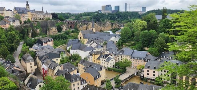
🇩🇪 Luxemburg ist eine geologisch vielfältige Stadt. Diese EarthCache wird Sie mit dem Geheimnis der Alzette Fluss vertraut machen.
🇬🇧
Luxembourg is a geologically diverse city. This EarthCache will introduce you to the secret of Alzette river.
🇫🇷 Luxembourg est une ville géologiquement diversifiée. Cette EarthCache vous fera découvrir le secret du Rivière Alzette.
Géologie de l’Alzette / Geologie der Alzette / Geology of the Alzette
🇩🇪 Die Alzette ist ein bedeutender Fluss in Luxemburg und ein linker Nebenfluss der Sauer. Sie entspringt in Frankreich und durchfließt auf luxemburgischem Gebiet zwei geologisch unterschiedliche Großlandschaften, den Oesling und das Gutland. Diese geologischen Gegensätze prägen den Verlauf des Flusses, die Form des Tals sowie die Art der abgelagerten Sedimente.
Im Oberlauf fließt die Alzette durch den Oesling, der überwiegend aus paläozoischen Schiefern, Phylliten und Grauwacken devonischen Alters aufgebaut ist. Diese Gesteine wurden während der variszischen Gebirgsbildung stark gefaltet und tektonisch beansprucht. Das Flusstal ist hier schmal und tief eingeschnitten, was auf eine Dominanz von Erosionsprozessen und eine relativ hohe Reliefenergie hinweist.
Im Mittel- und Unterlauf erreicht die Alzette das Gutland, das vor allem von mesozoischen Sedimentgesteinen wie Sandsteinen und Mergeln geprägt ist. Die geringere Festigkeit dieser Gesteine begünstigt die Ausbildung breiter Talauen und die Ablagerung quartärer Sedimente wie Sande, Kiese und Tone. Gleichzeitig wirken die Sandsteinschichten als wichtige Grundwasserleiter und beeinflussen den Abfluss sowie die Nutzung der umliegenden Landschaft.
🇬🇧
The Alzette River is an important river in Luxembourg and a left tributary of the Sauer River. It rises in France and flows through two geologically distinct regions within Luxembourg, the Oesling and the Gutland. These contrasting geological settings strongly influence the river’s course, the shape of its valley, and the nature of its sediments.
In its upper course, the Alzette flows through the Oesling, which is mainly composed of Paleozoic slates, phyllites, and greywackes of Devonian age. These rocks were intensely deformed during the Variscan orogeny. As a result, the river valley is narrow and deeply incised, reflecting dominant erosional processes and a relatively high relief energy.
In its middle and lower course, the Alzette enters the Gutland region, which is characterized by Mesozoic sedimentary rocks, especially sandstones and marls.
The lower resistance of these rocks allows the development of wider floodplains and the accumulation of Quaternary sediments such as sands, gravels, and clays. The sandstone layers also act as important groundwater reservoirs, influencing both the hydrological regime of the river and land use in the surrounding area.
🇫🇷 La rivière Alzette est un cours d’eau important du Luxembourg et un affluent de rive gauche de la Sûre. Elle prend sa source en France et traverse, sur le territoire luxembourgeois, deux grandes régions géologiques distinctes, l’Oesling et le Gutland. Ces contrastes géologiques influencent fortement le tracé de la rivière, la morphologie de sa vallée et la nature de ses sédiments.
Dans son cours supérieur, l’Alzette s’écoule à travers l’Oesling, une région constituée principalement de schistes, de phyllades et de grauwackes paléozoïques d’âge dévonien. Ces roches ont été fortement déformées lors de l’orogenèse varisque. La vallée y est étroite et profondément encaissée, ce qui témoigne de la prédominance des processus d’érosion et d’un relief relativement élevé.
Dans son cours moyen et inférieur, l’Alzette atteint le Gutland, caractérisé par des roches sédimentaires mésozoïques, notamment des grès et des marnes. La moindre résistance de ces roches favorise le développement de larges plaines alluviales et l’accumulation de sédiments quaternaires tels que les sables, les graviers et les argiles. Les formations gréseuses constituent également d’importants réservoirs d’eaux souterraines, influençant le régime hydrologique de la rivière et l’utilisation des terres environnantes.
Méandrage / Mäandrierung / Meandering
🇩🇪
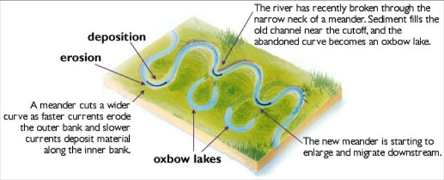
Mäander werden verwendet, um bestimmte Flusstypen anhand ihrer Form zu charakterisieren. Man unterscheidet drei grundlegende Flusstypen: verflochtene, gerade und gekrümmte beziehungsweise serpentinenartige Flüsse. In Flüssen, die durch Auenlandschaften fließen, können sich Mäander besonders leicht ausbilden, wenn das Gefälle gering ist.
Sedimente werden in der Regel im konvexen Bereich der Flussschlinge in einer zickzackartigen Bewegung abgelagert und anschließend seitlich in Richtung Ufer transportiert. In den konkaven Bereichen überwiegt hingegen die Erosion, wobei deutlich erkennbar ist, wie sich das Ufer infolge der Zentrifugalkraft zurückzieht. Durch das Zusammenspiel von Aufschüttung in der konvexen Zone und Abtragung in der konkaven Zone beginnt der Flusslauf zu wandern, wodurch Mäander entstehen.
Während sich der Fluss über einen porösen und durchlässigen Untergrund bewegt, werden die Ränder des natürlichen Abflussweges kontinuierlich erodiert. Mit fortschreitender Abnutzung nimmt das Flussbett eine charakteristische konkave Form an, wodurch sich zunehmend ausgeprägte Flusskrümmungen entwickeln.
🇬🇧
Meandering are used to characterize specific types of rivers based on their design. There are three types of tributaries: braided, straight and curved or serpentine. In the rivers that flow through the floodplain, meandering are usually easier to form when the slope is small.
The sediment is usually deposited in the bump in a zigzag fashion and then moves from there to the shore. In the recesses, erosion dominates, and it is clear how the filling retreats due to the centrifugal force. When the advance of the fill in the convex zone is combined with the retreat of the concave zone, the river course begins to migrate and meandering occur.
As the river moves over the porous, permeable surface, the edges of the natural passage through which the river continues to flow are eroded. As it wears out, it takes on a characteristic concave shape, which creates a curve.
Iron and manganese are minerals that can impart unique colors to sandstone, enhancing its visual appeal and strength of character. When these elements are present in the sandstone, they can produce a variety of hues including red, brown, yellow and even purple. The coloring process is based on the interaction of iron and manganese with the mineral composition of the sandstone and the environmental conditions.
🇫🇷 Les méandres sont utilisés pour caractériser certains types de rivières en fonction de leur tracé. On distingue trois types principaux de cours d’eau : les rivières en tresses, les rivières rectilignes et les rivières courbes ou sinueuses. Dans les cours d’eau qui traversent des plaines alluviales, les méandres se forment plus facilement lorsque la pente est faible.
Les sédiments se déposent généralement dans la partie convexe du méandre selon un mouvement en zigzag, puis sont transportés latéralement vers la rive. Dans les zones concaves, l’érosion domine, et l’on observe clairement le recul des berges sous l’effet de la force centrifuge. Lorsque l’accumulation de sédiments dans la zone convexe se combine avec l’érosion de la zone concave, le lit de la rivière commence à migrer et des méandres se développent.
À mesure que la rivière s’écoule sur un substrat poreux et perméable, les bords du chenal naturel sont progressivement érodés. Avec le temps, le lit prend une forme concave caractéristique, ce qui favorise la formation et l’accentuation des courbes du cours d’eau.
Types de rives / Ufertypen / Types of river banks
🇩🇪
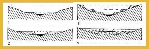
Mäandrierende Flüsse wechseln zwischen Bereichen mit schneller und langsamer Strömung. An den Prallufern, wo die Strömung besonders stark ist, wird Material abgetragen, wodurch tiefe Kolke und steile, teils senkrechte Uferwände entstehen. Am gegenüberliegenden Ufer verlangsamt sich die Strömung, Sedimente werden abgelagert und es bilden sich Aufschüttungen. Die Dynamik der Strömung zeigt sich dabei nicht nur in Veränderungen der vertikalen Achse des Flussbetts, sondern auch in seitlichen Verlagerungen des Laufs. Wenn sich das Flussbett verlagert und die Mäander weiter werden, gelangen größere und kleinere Holzstücke oder sogar ganze Bäume in den Fluss. Diese Hindernisse lenken die Strömung zur gegenüberliegenden Uferseite und können so die Entstehung neuer Mäander begünstigen.
Das Gleitufer und das Prallufer sind zwei unterschiedliche Ufertypen, die typischerweise in Mäanderbereichen auftreten. Sie spielen eine zentrale Rolle im Prozess der fluvialen Sedimentation und Erosion.
Das Gleitufer, auch als Aufschüttungs- oder Alluvialufer bezeichnet, entsteht hauptsächlich durch die Ablagerung von Sedimenten am Rand des Flusslaufes. Diese Sedimente werden vom Wasser transportiert und dort abgesetzt, wo die Fließgeschwindigkeit abnimmt. Solche Ufer sind in der Regel breit und weisen eine flache Neigung auf. Sie treten vor allem in Bereichen mit geringer Strömungsenergie auf, in denen sich Material ansammelt.
Demgegenüber steht das Prallufer, das durch starke Erosion infolge der Strömung gekennzeichnet ist, insbesondere in Mäandern. Diese Ufer sind meist steil und können eine felsige oder stark geneigte Oberfläche aufweisen. Das Wasser formt das Prallufer intensiv, wobei das erodierte Material in den Fluss transportiert und anschließend am gegenüberliegenden Gleitufer wieder abgelagert wird.
🇬🇧 In meandering rivers, areas of fast and slow flow alternate. On the impact banks, where water removes material, deep pools and steep walls form. On the opposite bank, where the current is slower, sediment is deposited, creating alluvial formations. The flow dynamics are reflected not only in vertical changes but also in horizontal shifts, as the river channel migrates laterally. As the course shifts and meanders widen, logs or even whole trees enter the river, creating obstacles that direct the force of the current toward the opposite bank, often forming the basis for a new meander.
Depositional and impact banks are two distinct types of riverbanks that occur near meanders and play a key role in river sedimentation.
The depositional bank, also called a depositional terrace, forms primarily through the accumulation of sediments along the riverbank. These sediments are carried by the river and settle when the flow velocity decreases. This type of bank is usually wide and gently sloping. It is common in areas where the river slows down and sediment tends to accumulate.
In contrast, the impact bank is a bank exposed to strong river erosion, mainly in meanders. These banks are typically steep and often have rocky or sharply sloping surfaces. Water strongly shapes the form of the impact bank, and erosion removes material from it, which is then deposited downstream on the depositional bank
🇫🇷 Les rivières à méandres alternent entre des zones d’écoulement rapide et lent. Sur les rives soumises à un courant intense, l’eau enlève le matériau, ce qui entraîne la formation de fosses profondes et de parois abruptes. Sur la rive opposée, où le courant est plus lent, les sédiments se déposent et des levées alluviales se forment. La dynamique de l’écoulement ne se manifeste pas seulement par des modifications de l’axe vertical du cours d’eau, mais aussi par des déplacements latéraux du chenal. À mesure que le lit change de direction et que les méandres s’élargissent, des troncs de tailles diverses, voire des arbres entiers, peuvent pénétrer dans la rivière. Ces obstacles modifient la direction du courant et concentrent sa force sur la rive opposée, favorisant souvent la formation d’un nouveau méandre.
La berge alluviale et la berge d’érosion sont deux types distincts de rives que l’on rencontre fréquemment dans les zones de méandres. Elles jouent un rôle essentiel dans les processus de sédimentation et d’érosion fluviales.
La berge alluviale, également appelée terrasse alluviale, se forme principalement par le dépôt de sédiments sur la rive d’un cours d’eau. Ces matériaux sont transportés par le courant puis déposés lorsque la vitesse de l’écoulement diminue. Ce type de berge est généralement large et présente une pente douce. On le trouve surtout dans les zones où l’énergie du courant est faible et où les sédiments ont tendance à s’accumuler.
À l’inverse, la berge d’érosion est une rive soumise à une forte action érosive du courant, en particulier dans les méandres. Ces berges sont généralement abruptes et présentent souvent une surface rocheuse ou fortement inclinée. La forme de cette berge est largement contrôlée par l’action de l’eau, et le matériau arraché est transporté par le courant avant d’être redéposé sur la berge alluviale située en face.
🇩🇪
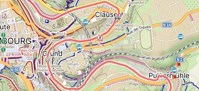
Um log als "gefunden" anzumelden, musst du mirüber mein Profil eine E-Mail senden und Antworten auf die folgenden Fragen und Aufgaben senden:
1) Wie wurde die Alzette durch die geologische Zusammensetzung des Gebiets beeinflusst, durch das sie fließt?
2) Machen Sie ein Foto des Flusses von den Startkoordinaten und veranschaulichen Sie darin, wie er sich auf natürliche Weise entwickeln und wandern würde, wenn er nicht durch menschliche Eingriffe reguliert wäre. Senden Sie mir Ihre Zeichnung zusammen mit Ihren Antworten.
3) Bestimmen Sie den richtigen Ufertyp für jeden Wegpunkt (die Typen wurden oben erklärt).
4) Untersuchen Sie die Umgebung an jedem Wegpunkt. Beobachten Sie Anzeichen von Wassererosion an den Ufern? Wenn ja, geben Sie bitte die entsprechenden Stellen an.
5) Basierend auf Ihren vorherigen Beobachtungen, bestimmen Sie, welcher Typ von Flussterrasse den Verlauf der Alzette vor der menschlichen Regulierung am besten widerspiegelt.
6) Machen Sie ein Foto von sich selbst oder Ihrem GPS-Gerät mit dem Fluss an den Startkoordinaten und fügen Sie es Ihrem Protokoll bei.
🇬🇧
For log as "found it" please send me answers for those questions via my profile:
1) How has the Alzette River been influenced by the geological composition of the area it flows through?
2) Take a photo of the river from the starting coordinates and illustrate in it how it would naturally evolve and migrate if it wasn't regulated by human intervention. Send me your drawing with your answers.
3) Determine the right river bank type of each waypoint location (types explained above).
4) Examine the surroundings at each waypoint. Do you observe any evidence of water erosion along the banks? If so, please indicate the locations.
5) Based on your previous observations, determine which type of river terrace best represents the Alzette’s course before human regulation.
6) Take a photo of you or your GPS device with the river on initial coordinates and attach it to your log.
🇫🇷 Pour vous connecter comme "trouvé", veuillez m'envoyer des réponses à ces questions via mon profil : 1) Comment la rivière Alzette a-t-elle été influencée par la composition géologique de la région qu’elle traverse ?
2) Prenez une photo de la rivière depuis les coordonnées de départ et illustrez-y comment elle évoluerait et migrerait naturellement si elle n’était pas régulée par l’homme. Envoyez-moi votre dessin avec vos réponses.
3) Déterminez le type de rive approprié pour chaque point de passage (types expliqués ci-dessus).
4) Examinez l’environnement autour de chaque point de passage. Observez-vous des preuves d’érosion de l’eau le long des berges ? Si oui, indiquez les emplacements.
5) Sur la base de vos observations précédentes, déterminez quel type de terrasse fluviale représente le mieux le cours de l’Alzette avant la régulation humaine.
6) Prenez une photo de vous-même ou de votre appareil GPS avec la rivière aux coordonnées de départ et joignez-la à votre journal.
🇬🇧
Please log the cache immediately after sending your answers, thanks.
By DanielKotmel, 2026. Sources -
Alzette [online]. Available from https://en.wikipedia.org/wiki/Alzette [17. 01. 2026]
Meander [online]. Available from https://www.britannica.com/science/meander-river-system-component [17. 01. 2026]
Fluvial features [online]. Available from https://www.nps.gov/articles/ meandering-stream.htm [17. 01. 2026]
Stream bank [online]. Available from https://www.lakesuperiorstreams.org/ understanding/streambank.htm [17. 01. 2026]
Sediment Transport [online]. Available from https://en.m.wikipedia.org/ [17. 01. 2026]
 |