 Aerial Intelligence cache is located in the Las Vegas area. The cache is not at the coordinates listed above!
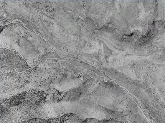
The US Army intelligence division of the XVIII Airborne Corps has identified a geocache in the area. Unfortunately they didn’t record the coordinates of the cache. They do know that the cache is located 23 miles, 4362 feet from the coordinates of N36° 10.444’, W115° 08.307’. The aerial photograph shown below is a picture of the cache site. Draw a straight line from the upper right corner of the picture to the bottom left corner. Near the center of the line you will find a cairn with a old tin can inside . Find this location. From this location walk 292 feet at a bearing of 233 degrees magnetic to find a rock cairn that contain an Altoid tin. Inside the tin you will find the coordinates to the cache which is about a mile hike.
Interpreting Aerial Photographs
Interpreting an aerial photograph requires a little skill. People spend years becoming proficient photo-interpreters, and the amateur or casual user of these images is wise to spend a few minutes learning to distinguish a small cloud shadow from a small lake, an air force base from a civilian airport, or a stand of young timber from a grassy hillside.
What to Look For
Aerial photographs contain a lot of information, anomalies in drainage patterns, landforms to make deductions about the subsurface and structures will identify the area. The interpreters are likely to examine the photographs and USGS topographic maps together, perhaps alternating between the two to connect place names and road numbers with unidentified features in the photographs.
Go to the following web site to search for the cache site:
http://http://www.google.com/earth/index.html or http://http://maps.google.com I highly recommend that you use google earth which has more detail in its satellites view of the earth.
The cache is in a small canister under a pile of rocks.
Please do not post pictures that would give away the location and please refrain from giving out measurements or description of the site! Thanks