| This cache has three locations
and four waypoints that you will need to locate. The material you
need to find the cache will be set like this text so that you can
skip all the history stuff if it doesn't interest you. If you
drive, this cache will probably take you less than an hour to
complete. If you walk, I'd allow about two hours. Church Hill has a
reputation in Richmond that greatly exceeds the reality. We spent a
great deal of time wandering the area looking for suitable
locations and never felt at risk in the slightest. I probably
wouldn't suggest going to the final cache location alone at night,
but otherwise you should be perfectly fine. In fact, the second
location offers one of the coolest views in the city at
night. |
In the years following the Civil War, the Shockoe Valley was the
hub of the city and trains were the key to commerce. When the
Chesapeake and Ohio railroad suggested a tunnel under Church Hill
would be the best way to go, Richmond's City Council came up with a
$300,000 bond in 1871. In February 1872, work started on the more
than half a mile long tunnel at both ends, with a force of more
than 400 men. This was the first effort to tunnel through
Richmond's many hills and there were many signs that the geology
wasn't well-suited to the attempts. In May, there were two separate
collapses in the vertical shafts dug to access the tunnels. By
January, cracks were appearing in the ground of Church Hill above
the tunnel. They became serious enough to evacuate residents on
January 13 and on January 14 a section between 24th and 25th
streets collapsed, ruining three houses and the Third Presbyterian
Church. In the end, the tunnel took almost a year longer than
expected and cost more than twice the original estimate.
Nonetheless, when it opened on December 11, 1873 it was hailed as
an engineering marvel and a great success. Until 1902, trains used
it as the regular route to the Main Street station. At that time,
the current route along the river on the high trestle (next to our
Ship, Lock and Key cache) was opened and the C&O stopped using
the tunnel. The primary reason for building this route was
apparently the delays in traffic when trains entered the tunnel at
the western portal. In 1913 the city extended the eastern end of
the tunnel, but serious efforts to reopen it didn't arrive until
1925.
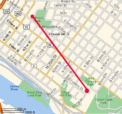
Map showing approximate path of the tunnel
C&O began serious efforts to repair and reopen the tunnel in
the Fall of 1925. In September, surface damage above the tunnel was
noted and railroad crews began inspecting and preparing the tunnel
to reopen. On October 2, 1925 engineer Thomas J. Moson drove a
locomotive pulling 10 flatcars nearly all the way through the
tunnel, parking around 100 to 150 feet from the western portal. As
workers were digging at the foundations, a brick or two rained down
from the roof. As the workman ran frantically to safety, the tunnel
collapsed completely burying Mason and crushing the train, sending
scalding steam in all directions. The fireman, Benjamin Mosby was
seriously burned by the steam, but managed to crawl under the train
and walk a mile or more to the other exit. Unfortunately, he died
in the hospital later than night. The conductor, G.C. McFadden,
escaped with a broken arm and the brakeman, C.S. Kelso suffered
head injuries. There is some controversy concerning the others
trapped in the collapse. C&O initially reported one
African-American laborer was unaccounted for and later amended the
list to two. One was Richard Lewis and the other was H. Smith.
There have been a variety of reports that claim variously that
Smith actually escaped and was later seen elsewhere or that as many
as 15 other African-Americans remain buried in the tunnel. Record
keeping was clearly not up to modern standards and most of the 200
or so laborers were hired day to day and no one really knows who
may have been trapped in the collapsed tunnel. A massive excavation
and rescue effort was halted once the body of Mason was located and
the rest of the collapsed section has never been excavated and
searched, so no one can say for sure.
| Proceed to the coordinates
posted for the cache. You will find yourself at the mouth of the
tunnel on the western end. You are probably facing a sign
memorializing the event above the entrance portal. On the (now
missing) sign, a section reads "75 years to this day". Call the
first digit A (7) and the second digit B (5). Proceed to the
entrance of the tunnel below and note that there is a year marked
on the tunnel mouth. Call that date CDEF. In other words, if the
date is 1987, C is 1, D is 9, E is 8 and F is 7. Your next waypoint
is 37° 3C.DFA 77° EB.(E+C)AB. You might reflect on the tragedy that
not only were these men not identified, but that their final
resting place has become a dump. If we each practice
cache-in/trash-out, maybe we can change that. |
If you like, you could walk 150 feet up the hill into the park
and stand near 37° 32.151 77° 25.374. That would be a spot very
close to where the train rests today directly under your feet. The
coordinates we've selected for the second location aren't quite
over the top of the tunnel, but it isn't far from it. It should
give you a very clear view of why the tunnel was needed. At the
point where you stand, the tunnel is about 100 feet below the
surface.
Proceed to the coordinates
noted in the first step. You should see another sign. Make a note
of the following numbers:
G = James River
H = Riverfront Towers
I = Main Street Station
J = Tyler Building
K = last digit of City Hall
LL = both digits of the Martin Luther King Bridge
The third location you need to go to is 37° HG.IKK 77°
LL.JKK |
You are now overlooking the other side of the tunnel. The train
tracks you see are essentially the same ones that were in place in
the 19th century. They just curved alongside the hill you are
standing on and went into the ground under the hill just to your
right. You can check your GPS to see how far you are from the first
location. It would have been a terrible walk in the dark after the
collapse of the tunnel. All of the men (variously reported as being
from 100 to 200 or more) who escaped from the collapse, escaped
this way.
The octagonal building you see to your left (as you face the
river!) also sits on a fairly well-known underground structure.
This is the site of a mid-1800s German brewery and they had six
massive brick vaults to store their beer buried just under the
building. The biggest vault is more than 500 square feet and they
have to be inspected periodically when they have earth slides here.
I am told there is no beer left.
As with almost any Richmond site, it is impossible to avoid
Civil War history. You are standing on the site of a large Southern
hospital during the war. It occupied 40 acres all around the area
where you stand. It could hold over 3,000 patients and treated more
than 76,000 during the war years. The mortality rate here was 10%
(some reports say 20%), which wouldn't make MCV very happy, but was
in fact quite extraordinary at the time. It was said to have been
the largest military hospital in the world at the time.
You are also loosely in the area of Powhatan's Seat, the
legendary home of the famous Indian leader who is perhaps best
known today as Pocahontas' father. There are interesting historical
markers along the ridge of this famous Hill.
| If you did this right, you
should be looking at another sign. Let the last two numbers on the
sign be MN. The last two digits of the first number on the sign
will be called OP. You will find the cache at 37° MG.NIM 77° LL.JPO
It should be a very short walk to the cache, but you'll probably
want to go down and around the octoganal building. Otherwise, you
might get to the cache a little faster than is safe. |
The way the cache is hidden is a bit of a joke. It is a very
common method, carried to a bit of an extreme. We may eventually
change it, but it amused us at the time.
Should you be interested, the other portal of the tunnel is
located near 77° 31.611 77° 24.892. You can continue on the trail
you took to the cache or you could start from the end of Franklin
Street (near 31st). The property is still owned by the railroad,
although clearly abandoned. It is an even more depressing dump than
the other portal. If you were especially adventurous and not too
concerned with the legal niceties, you might crawl through the hold
cut in the chain link fence into the tunnel itself. If you were
even more bold, you might find a place where you could crawl
through and go a surprisingly long way into the tunnel. Not that I
think it is a very good idea. I'd hate for it to collapse on
you.