Laaer-Wald Multi-Cache
-
Difficulty:
-

-
Terrain:
-

Size:  (regular)
Please note Use of geocaching.com services is subject to the terms and conditions
in our disclaimer.
This family cache is located in the 10th district in the south of Vienna. It´s in the recreation-area called "Laaer-Wald".
 The area was a former clay pit. The ponds are the result.
You can reach the cache area by public transport. Take the U1 to "Reumannplatz", and there you take the bus 68A till "Theodor-Sickel-Gasse". Those coming by car, can park at the given coordinates (entry from "Bitterlichstraße"). The trail is most of it`s length a gravel walk. Strollers can be used. Only for the very last meters before the hiding place you have to leave the way. A compass is needed. Opening hours: The area of Laaer-Wald is open for the public every day from 8 am till dawn (depending on the season: 4.30 pm in winter, 9 pm in summer. See notice at the door!) Dogs are not allowed.
Length: 3 km, no difference in height.
Details about the area can be found at: http://www.wien.gv.at/umwelt/wald/erholung/laaerwald.htm (site in german).
The above difficulty and terrain rating was done with the program from geocaching.com. To be internationally comparable I`m using this result. (See the discussion in the forum also.) My personal opinion is a rating of 2 stars for difficulty and 1.5 stars for terrain.
Stage 0: Initial Point
N0 = 48° x0´ where x0 = 09.587
E0 = 016° y0´ where y0 = 23.909
This is a good point for starting your adventure. You can park your car here and get an overview about the area.
Stage 1: The Raised Hide
N1 = 48° 09.728´
E1 = 016° 23.726´
Hide yourself and wait for the appearance of the foul-smelling green dragon close to the sign post. In which direction (from the raised hide) does it stop?
NW, then A = 1
NE, then A = 2
SE, then A = 4
SW, then A = 8
Stage 2: Butterfly, my butterfly
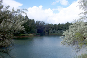
Now go to the pond to the place at which the photo on top of the page was taken. There are two ponds but the right place is easy to find. Hint: A signpost will guide you down. You don't need to climb over fences or something else! Stay on your path and you will succeed!
Find out the highest number on the water gage (the instrument to measure the water level):
Is it 140 then B = 102
Is it 190 then B = 113
Is it 240 then B = 125
Is it 290 then B = 137
Stage 3: We don't need no education...
N3 = 48° x3´ where x3 = x0 + (B * 4 + 1) / 1000
E3 = 016° y3´ where y3 = y0 - (A * A - 6) / 1000
One of the animals contains a number in its name. Call this number C.
Stage 4: Sweet Dreams
Enter now the leisure park "Böhmischer Prater". There are fun rides, restaurants and beer gardens. Walk along and relax. Search for a tram stop. Call the black, round line number which operates the tram (visible on top of the roof, front side) as D.
Stage 5: The Caterpillar
Not far from the tram stop is an old merry-go-round. When was it built by Rudolf Rusniak? Subtract 1900 and call the result E.
Stage 6: The Cache
Now you should be ready to calculate the final position:
N6 = 48° x6´ where x6 = x0 + (B - A + C + 2*D + E + 1) / 1000
E6 = 016° y6´ where y6 = y0 - (C * D - A + E - 4) / 1000
Use the path as long as you can. Leave the trail only for the last meters. Good Luck!
The cache initially contains:
- cachenote (please don´t remove)
- logbook (please don´t remove)
- pencil (please don´t remove)
- film
- telephone cards (3)
- wooden pig
- frog
- key fob (medallion)
- spider (to protect the cache) ;-)

After you've found this cache please rate it at GCVote!
The average rating of this cache is  stars of five. (One star is bad, 5 stars are excellent)
Happy caching, PlanetEarth
Version: 1.8
Additional Hints
(Decrypt)
[Stage 2]: Ohggregrvpu
[Stage 3]: Fvatyr qvtvg ahzore
[Cache:] Uvqqra haqre na haanghenyr cvyr bs oenapurf nxn "obne tevyy"
Treasures
You'll collect a digital Treasure from one of these collections when you find and log this geocache:

Loading Treasures