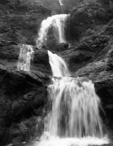
 Carson Falls is one of the treasures of the Marin watershed. Outdoors writer Tom Stienstra described it as the best falls in Marin. It is a series of cascades set among dramatic rocks and gnarled Buckeyes. The hike is best after the rains when the waters are flowing, but can be enjoyed any time of the year. What you will see (and the difficulty of the terrain) depends on the route that you take.
There are many ways to get here. Most people seem to come from Pine Mountain Road, the route that is described in the Bay Area Hiker. I prefer to take Old Sled or a nearby trail that that takes you up a fern-lined creek to the top of the gap. In either case, recent trail work and bridges have the final approach to the falls much easier than it used to be.
For more of an adventure, you can start at the Lily Gulch trail beginning at mile marker 5.88 along the Bolinas-Fairfax Road. This trail takes you past Dutchman's Rock to Oat Hill Road and then down to the old Big Trees Camp. The redwood grove there is beautiful, across Carson Creek the trail follows the stream as it tumbles over rocks up to the falls themselves. Other hikers have posted their pictures of this route -- it is not the fastest or easiest way, but it is very nice..
You can also bicycle down the Alpine-Kent Pump road to the first pump house (near the Pipeline cache). From there, take the first road right, which leads to the redwood grove. Find a safe place to leave your bikes and walk to the cache.
The cache is near the top of the falls. It is a typical ammo can hide. It should not be difficult to find, and is visible from the right spot, but please be sure to replace it exactly as you found it.
The falls, rocks, and the view of the canyon below are the real rewards for coming here. If you came from the top, take the trail down to the base of the falls. For more information, see Hiking Marin (Don and Kay Martin) or the map A Rambler's Guide to the Trails of Mt. Tamalpais and the Marin Headlands.