Português
A caçada
Esta multicache tem 3 etapas, no entanto só a final tem uma
cache. Nas outras apenas vos convido a apreciar o local e fazer
umas continhas. Dou alguma informação sobre os locais nesta página,
mas encontrarão mais na cache final.
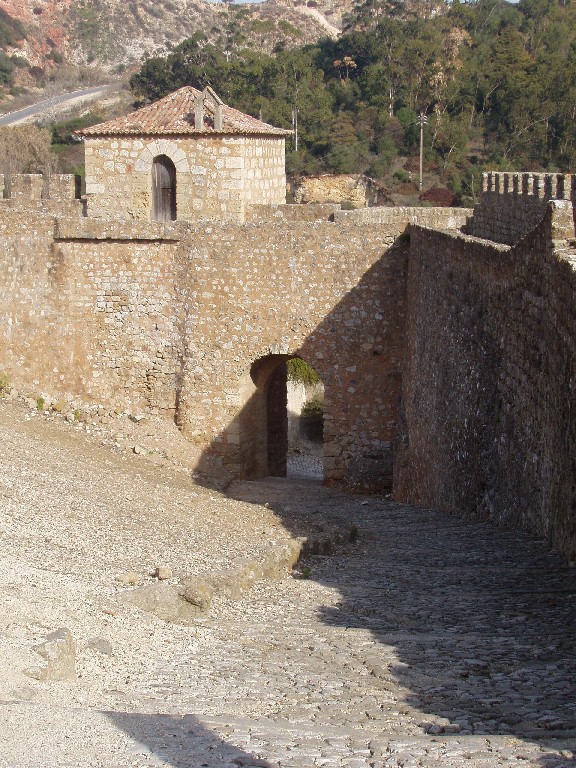
1a etapa - O Castelo de Alenquer
 De história milenar, as origens da fortificação remontam à época
Moura, quando era um dos baluartes mais importantes do lado Norte
do Tejo.
Infelizmente a história ditou que o castelo tenha sido várias
vezes arrasado. D. João I fê-lo em 1385 para punir o Alcaide de
Alenquer que tomou partido de Castela na disputa pelo trono e
outras vicissitudes levaram a que neste momento só restem algumas
partes da muralha, a porta da Conceição e a bizarra torre da
Couraça com uma habitação abandonada no topo.
Infelizmente algumas partes deste castelo incluindo a dita Torre
também não estão a ser devidamente mantidas. Serve esta cache
também para alertar para isso.
Para cá chegar não é difícil, sendo Alenquer sede de concelho e
bem indicada nas estradas próximas. Há uma saída da A1 próxima e
basta seguir as indicações para a Vila Alta e para Monumentos que
estão na estrada principal. Se vierem da A1, terão de virar à
esquerda nessas placas.
Para chegar à etapa seguinte:
Em que ano conquistou D. Afonso Henriques este castelo? Esse número
será A.
Quantas ameias (zonas sobre-elevadas da muralha, não são as
rebaixadas) há à esquerda da porta? Esse número será B. E à
direita? Esse número será C.
Às coordenadas do castelo realize as seguintes operações: latitude
(Norte) + A + 328; longitude (Oeste) + C*100 + B*3 - 3
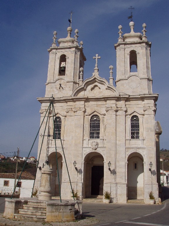
2a etapa - Basílica de Meca
 Conta a lenda que no século XIII apareceu Sta. Quitéria na quinta
de S. Brás. A esta santa foi dedicada a basílica, construída pela
confraria do mesmo nome no século XVIII sob a protecção de D. Maria
I. O estilo evoca o grande mosteiro de Mafra e interiores de grande
beleza, donde se destacam as telas dos altares do cruzeiro,
representando João Baptista e A Última Ceia, pintados por Pedro
Alexandrino. Uma pérola escondida!
Para chegar a Meca, vindo de Alenquer, há que tomar a estrada
nacional N8 em direcção a Torres Vedras. Cerca de 5km após Alenquer
passarão por uma localidade chamada Estalagem. Logo após há um
cruzamento à direita para Meca.
Para chegar à etapa seguinte:
Em que ano ocorreu a aparição? Esse número será D.
Quantos candeeiros tem a fachada da igreja? Esse número será
E.
Às coordenadas da basílica já obtidas realize as seguintes
operações: latitude (Norte) + D - 701; longitude (Oeste) - E -
5.
3a etapa
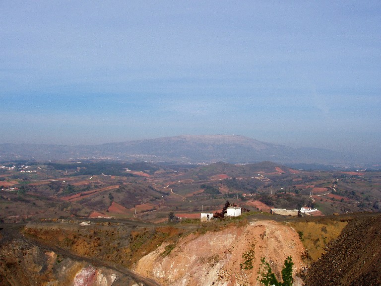
 A cache é um tupperware transparente envolto num saco negro. Está
localizada perto de uma pedreira activa. Isto tanto lhe pode dar
charme, como causar umas dores de cabeça. Como tal recomendo que
vão ao fim de semana, quando a pedreira está sem gente e calma. Se
quiserem ir durante a semana tenham atenção aos trabalhos da
pedreira.
O conteúdo inicial da cache inclui:
- Logbook e lápis e caneta
- Stashnote
- Explicação sobre o castelo de Alenquer e a Basílica de Meca
- TB Flash & Tarugo
- Bilhete válido para a Expo2005 em Aichi Japão (quem for lá que me
conte como foi depois!)
- Nota de 500 Afghanis
Para chegar à cache, continuando para lá da basílica de Meca
(circulando à direita desta) segue-se a estrada por umas centenas
de metros até encontrar uma placa à esquerda para Catém. Aí virar,
e logo depois virar na estrada alcatroada à direita. É uma estrada
larga usada pelos camiões da pedreira.
Podem estacionar no fim do alcatrão e seguir a pé daí. Se for
fim de semana, circulem a pé por onde vos apetecer. A subida ao
topo da pedreira é recomendada, mas tenham cuidado com os
precipícios. Caso queiram evitar a pedreira, há um trilho abaixo
desta que parte da zona de estacionamento que recomendei, circunda
a pedreira logo abaixo dela pela direita, e chega quase até à
cache.
English
The hunt
This multicache has 3 stages, but only the final one has a
container. In the others I just invite you to enjoy the places and
do simple maths. There is some information about these places here,
but you will find more in the cache.
1st stage - Alenquer Castle
One thousand years of history have these walls. The origins go
back to the Moorish time, when it was one of the main defensive
strongholds, north of the Tagus.
Unfortunately it was punished hard during its history. Among
others, John I of Portugal did it in 1385 to punish the Alenquer
Mayor who took the side of Castille in the dispute for the throne.
Other events led to only a few sections of the wall, the Conception
Gate and the bizar Courace Tower (with a house on top) having
survived.
Unfortunately some parts of the castle, including the Tower are
not being kept properly. This cache also intends to call everyone's
atention to that.
To arrive there it isn't hard. Alenquer is well signed. You can
take the A1 exit pointing here and follow the indications of Vila
Alta and Monumentos to the left.
To get to the next stage:
In what year did D. Afonso Henriques conquer this castle?That
number will be A.
How many elevated areas are there on the wall (I mean the small
protections raised to protect the soldiers guarding the wall) to
the left of the door? That will be B. And to the right? That
will be C.
To the castle coordinates do the following maths: latitude (North)
+ A + 328; longitude (West) + C*100 + B*3 - 3
2nd stange - Meca Church
The lengend tells that in the XIII century here in S. Brás farm,
appeard Saint Quitéria. To her was dedicated the church. Built with
the protection of Queen Maria I of Portugal during the late XVIII
century. The style is similar to the great Mafra monastery and the
interiors are of great beauty. They include paintings of John
Baptist and the Last Supper by Alexandrino. No doubt, a hidden
pearl.
To get to Meca, from Alenquer, take the N8 road to Torres
Vedras. About 5km after Alenquer you will find Estalagem village.
After that there is a turn right signalizing Meca.
To get to the next stage:
In what year was the apparition? That number will be D.
How many lamps are on the façade of the church? That will be
E.
To the current church coordinates do the following: latitude
(North) + D - 701; longitude (West) - E - 5.
3rd stage
The cache is a transparent tupperware wrapped in a black bag. It
is located near an active quarry so that can be both charming or
give an headache. I reccomend a weekend visit when there is no one
in the quarry. If you go during the week, mind the trucks.
Initial contents include:
- Logbook pencil and pen
- Stashnote
- TB Flash & Tarugo
- Valid ticket to 2005 World Exposition in Aichi, Japan (tell me
about it if you go)
- 500 Afghanis bank note
To get to the cache, go beyond the church, by the right side for
a few hundred metres. You will find a sign to the left for Catém.
Turn there and then turn right on the asphalt road nearby. It is a
wide road used by the quarry trucks.
You can park at the end of the tarmac and go on foot from there.
If it is weekend go wherever you please. The climb to the top is
recommended but be careful with the high cliffs. If you want to
avoid the quarry there is a trail just below it circling it by the
right side. It goes almost to the cache.