During the Pliestocene, cycles of glaciation reshaped the land,
meltwater from glaciers created new rivers, and most signs of the
ancient riverbed were erased.
To claim this earthcache, email me an estimate of the width of
the stream under the bridge and discuss how the direction of flow
for this modern watercourse compares to the course taken by the
ancient Teays and the more modern Mahomet drainage systems.
A watershed is the surface area of the state from which all water
appears to run to or "drain to" a common body of water, like a
river. Today, Indiana has six distinct watersheds including, the
Illinois, the Lake Michigan, the Maumee river, the Ohio river and
the Wabash river. Of these, the largest by far is the Wabash river
watershed. The Wabash river collects waters from streams throughout
the state of Indiana.

Two million years ago, in the Tertiary period, the landscape of
the US mid-west was very different than today. Scientists still
debate the exact details of the pre-glacial landscape.
Some scientists believe an ancient, massive river, called the Teays
River was once the primary river for a extensive watershed.
According to work done from the early 1900s until the mid 1980s,
the Teays drained much of Virginia, West Virginia, Ohio, and
northern Indiana before joining the preglacial Mississippi River in
northern Illinois.
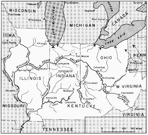

Work begun in the 1980s suggests that the Teays River may not have
entered Indiana at all, but instead a second major system, known as
the Marion-Mahomet Valley stretched across Illinois and
Indiana—joining with the ancient Teays in Ohio only after the
advance of several major glaciers.

More about the Marion-Mahomet
The Marion-Mahomet Valley lies far beneath the landscape, deeper
and wider than the current river valley. The Marion-Mahomet Valley
begins in western Ohio, enters Adams county at the Indiana line,
traveling southwest to near Hartford city before turning in an arc
to sweep just north of the Mississinewa and Wabash rivers to
Lafayette, and on into Illinois.
Early geologists presumed the buried bedrock to be pre-glacial, and
many studies used it as a model of Indiana before glaciers
resculpted the landscape. Research since the 1980s suggests that
the riverbed buried beneath the Salmonie and Wabash rivers is not
as old enough to have been joined to the ancient Teays river, and
contained rock layers not found in the Teays system.
Now it appears the deep valley may have been the direct result of
glacial meltwater deepening and widening young meltwater streams.
Rocks from the Teays system, found in the aquifer system of the
area, are now thought to be shallow deposits from glacial meltwater
dating from after the merging of the Marion-Mahomet and the Teays
system.
More on the Teays river research
This dramatic, rapid, alteration of the landscape was not thought
possible until recently, and early geologists were quick to link
the meandering Teays river valley to the Wabash river system.
Before the Pleistocene period (the Ice Ages), the Teays River
flowed from its headwaters in western North Carolina through the
southeastern Unites States into the upper midwest, before turning
to drain into the Gulf of Mexico. The river journeyed northward
from Virginia through southwest West Virginia, skimming between
Kentucky and Ohio before traversing across Ohio to drain nearly 2/3
of that state before turning to cross Indiana. The ancient river
system is still visible in satellite imagery of part in southern
Ohio. (insert image of river drainage area)Newer research has
discovered evidence of the ancient preglacial "Teays" flowing
northward to the present Erie lowland, rather than turning to enter
Indiana. The Teays only bridged the gap across Indiana after the
Mahomet valley developed across Illinois during the pre-Illinoian
glacial period.
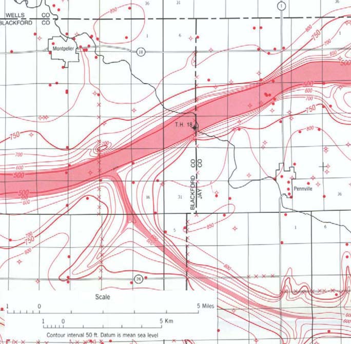
Most of what we know about the subsurface valley comes from
observations gleaned from small remnant streams, core samples taken
from underground wells, and satellite imagery showing dry river
valleys. Investigations in 2005 of subsurface area found
stream-deposit quartzite till pebbles from headwaters of the
ancient Teays River in Indiana, proving the ancient Teays did join
with the more modern Marion-Mahomet at some point. The data will
undergo analysis for the next several years, and the debate over
the exact course of the Teays will likely continue for many years
to come because the land has been greatly modified by glacial
erosion and deposition.
Interaction of the subsurface and surface.
Core samples taken in the area suggest the buried river channel is
at least a mile wide and 260 feet deep below your feet, and drained
from the east-northeast to west-southwest. The alluvial sands
capping the bedrock layers create aquifers to hold abundant fresh
water to local communities. Though concerned with surface water
contamination, the water several hundred feet below ground meets
the local needs for fresh water even during extended droughts.
This cache was modified from the original version created by
greengecko.
More info: http://tapestry.usgs.gov/features/41teaysriver.html
Camp, M. J. and Richardson, G. T., 1991, Roadside geology of
Indiana: Mountain Press Publishing.
Melhorn, W. N., and Kempton, J. P., eds., 1991, Geology and
hydrogeology of the Teays-Mahomet bedrock valley system: Geological
Society of America Special Paper 258, 128 p.
http://www.dnr.state.oh.us/geosurvey/geo_fact/geo_f10.htm
http://en.wikipedia.org/wiki/Teays_River
https://kb.osu.edu/dspace/handle/1811/3568
http://hdl.handle.net/1811/3568
http://www.ohvec.org/old_site/streams05.htm
http://www.indiana.edu/~librcsd/etext/hoosier/GM-23.html
THE NATIONAL WEATHER SERVICE FORECAST FOR THE LOCAL AREA
