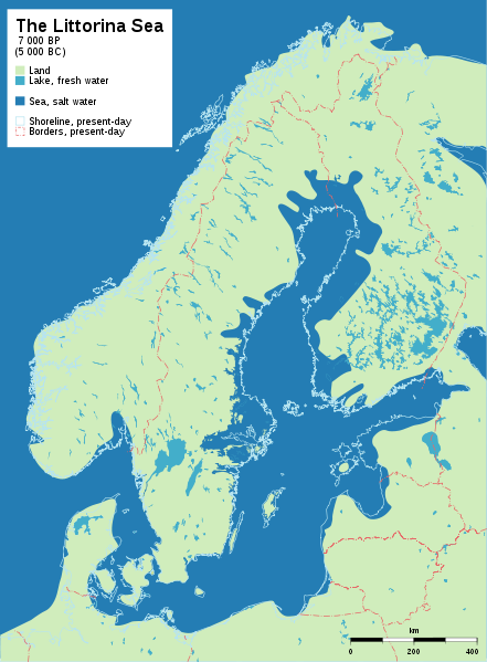
The Scandinavian shingle eskers were piled up by the meltwater rivers in consequence of the climate amelioration at the end of the last ice age, somewhere in the region of 10,000 years ago. The large esker mantle running through the earthcache location has a cover of wave sorted sand, gravel , pebbles and cobbles filling dead ice depressions. The other striations in the esker core can be clearly seen in the nearby gravel pit. The wave exposed sides of the esker are gently sloping abrasion surfaces with lagging boulders and the lee sides are covered with wave transported evenly sorted coarse surge gravel. The upper surfaces are characterised by gravel and shingle ridges. It is these shingles that are evident at the position you are at. Today's coastline is at it's closest point nearly 40km from this shingle ridge which continues north to Åshammar then on to Järbo and Jädraås. In parts the wave reworked esker cap contains enriched fragments of bivalves and gastrapods of the Littorina sea age.
The local exposed part of the shingle esker stretches between about N60 33.239 E16 33.012 and N60 33.206 E16 33.215. The nearby gravel pit clearly demonstrates what is to be found inside the esker in terms of the striations.
To log this earthcache as found you have to mail the cache owner with answers to the following:
- Using your GPS determine the elevation of the shingle field then calculate the average height that the land has risen per year.
- Describe what the stones look like. Give their size, colour and surface texture.
It is not a requirement to log the find but it would be nice if your log included a photo of the field with your GPS'r in the picture and people if possible.
 The most exciting way to learn about the Earth and its processes is to get into the outdoors and experience it first-hand. Visiting an Earthcache is a great outdoor activity the whole family can enjoy. An Earthcache is a special place that people can visit to learn about a unique geoscience feature or aspect of our Earth. Earthcaches include a set of educational notes and the details about where to find the location (latitude and longitude). Visitors to Earthcaches can see how our planet has been shaped by geological processes, how we manage the resources and how scientists gather evidence to learn about the Earth. To find out more click HERE.