
 The San Andreas Fault is the boundary between the Pacific Plate to the west and the North American Plate to the east. This is one of the few plate boundaries where you can walk from one plate to the next. Most other plate boundaries are under water.

Source: USGS (http://pubs.usgs.gov/gip/earthq3/what.html)
The San Andreas Fault is called a transform fault because the plates on either side of the fault are predominantly moving past each other. No matter which plate you are standing on, the other plate appears to be moving to the right, thus this is called a right lateral strike-slip fault. The result is that the Pacific Plate is moving northward compared to the North American Plate. One of the pieces of evidence for this movement is coorelation between the rocks at the Pinnacles National Monument (GCPRKP and GCPRKJ) and the rocks of the Neenach formation (GCQ5FZ)
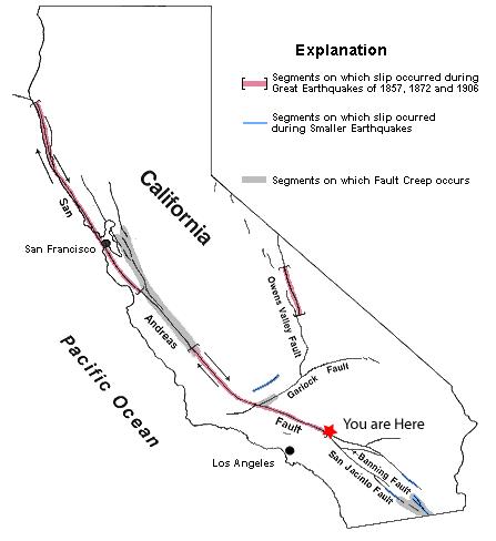
source: USGS (http://pubs.usgs.gov/gip/earthq3/where.html)
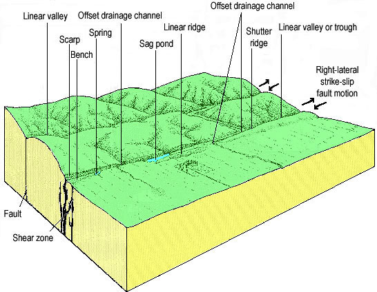
Four of the many geomorphologic features typical of strike slip faults can be seen at two locations in the area. The geomorphology of an area is the explanation of the events and processes that have resulted in the current landforms of the region. These include the Cajon Pass, bench topography, the linear valley, and a sag pond. The sag pond is at the secondary point. Not all of these features are easily recognizable.
The Cajon Pass
The Cajon Pass sits between the San Gabriel Mountains to the west and San Bernardino Mountains to the east. The San Andreas Fault cuts between these two mountain ranges forming a relatively low elevation pass compared to the surrounding mountains. In addition the distance from one side of the mountains to the other is less than in other places along the mountain ranges.

Source: Geologic Map of the San Bernardino Quadrangle, State of California, Division of Mines and Geology
Linear Valley (1.5 star difficulty)
The shape of Lone Pine Valley, the one you are in, is a direct result of the San Andreas Fault. The valley follows the straight line of the fault from the northwest to southeast. This feature is called a fault controlled valley.
The reason the valley follows the fault line is due to the weakening of the rocks near the fault line. The fault breaks up the rocks as the two rock masses move past each other. This makes it easier for water, wind, and plants to erode the rocks along the fault line. Over the years, a valley forms that roughly follows the fault.
Bench Topography (3.5 star difficulty)
Bench Topography can be seen in the hills along the south side of the valley. The ridges that come down into the canyon originally had a relatively constant slope. Now the ridges have an area that is slightly less of a slope about ¾ the way down the ridge. This is the approximate location of the San Andreas Fault. While still difficult to see, I found it easiest to look back down the canyon (to the southeast) to get a side view of the ridges.
 Sag Pond (0 star difficulty) Go to N 34 16.361 W 117 27.924
Movement along the fault causes cracks and fractures in the rocks adjacent to the main line of the fault. This area of cracks and fractures is called the fault zone. While the main movement along the San Andreas is right-lateral strike-slip, blocks of rock in the fault zone experience a variety of movements. Sometimes a block of rock ends up moving down, creating a depression. When this depression fills with water, it becomes a Sag Pond. This little lake is called Lost Lake.
Logging requirements:
Send me a note with :
- The text "GCQ7Z7 San Andreas Fault - Cajon Pass Earthcache" on the first line
- The number of people in your group.
- What will happen the next time the San Andreas fault breaks :
- to the distance between the object at the coordinates and the sag pond
- The relative movement of the object at the coordinates compared to the San Gabriel Mountains
- The relative movement of the object at the coordinates and the San Bernardino Mountains
The following sources were used to generate this cache:
- Morris, Ron, Joshua Myers, 1998, THE CAJON PASS VIRTUAL FIELD TRIP (http://seis.natsci.csulb.edu/VIRTUAL_FIELD/Cajon_Pass/cajmain.htm)
- USGS Earthquate Hazards Program, Glossary of earthquake Terms (http://earthquake.usgs.gov/image_glossary/transform_fault.html)
- National Atlas of the United States®, San Andreas Fault, Last modified: June 28, 2005 12:20 (http://nationalatlas.gov/articles/geology/features/sanandreas.html)
- Online version of "The San Andreas Fault" U.S. Geological Survey, Maintained by John Watson and Kathie Watson Last modified 06-24-97 (jmw) (http://pubs.usgs.gov/gip/earthq3/contents.html)
- Geologic Map of the San Bernardino Quadrangle, California, 1:250,000, Combilation by E.J. Bortugno and T.E. Spittler, Published 1986, Revised, 1998, State of California Division of Mines and Geology
- Robert E. Wallace Ed. The San Andreas Fault System, California U.S. GEOLOGICAL SURVEY PROFESSIONAL PAPER 1515, 2. GEOMORPHIC EXPRESSION http://3dparks.wr.usgs.gov/pp1515/chapter2.html
- http://3dparks.wr.usgs.gov/haywardfault/html/glossary.html#geomorph