Com esta cache vamos apresentar-te o mais antigo
marégrafo em funcionamento. No início deste ano tivemos o
privilégio de o visitar e conhecer. Tentamos agora partilhar
essa
experiência.
We would like to present you the oldest working
Tide Gauge. We had the privilege of visiting it earlier this
year. We are now trying to share this
experience.
Marégrafo de Cascais /Tide
gauge located in Cascais
O que é um marégrafo?
What it is a tide
gauge?
Os
marégrafos são instrumentos que medem e registam a altura das
marés. Alguns cálculos simples permitem, posteriormente, determinar
o famoso “nível médio da água do mar” constantemente referido em
cartas militares e outros documentos.
Tide
gauges are instruments that measure and record the amplitude of the
tides. The values recorded can then be used to determine the famous
“sea level”. The sea level is a very important data, because it is
used in maps, charts and other related documents, allowing us to
know, for instance, the altitude of a hill.
Como funciona? How
does it work?
Medir a altura das marés pode parecer complicado, mas
afinal é tão simples! Basicamente um marégrafo consiste numa bóia,
ligada a um cabo, que por sua vez está ligada a um enorme tambor,
que gira lentamente ao ritmo de um relógio mecânico. Uma caneta de
cor, vai marcando o nível da água à medida que o tempo passa… tal
como num sismógrafo!
Para
não se registarem grandes oscilações (devido à passagem de barcos,
ventos e correntes fortes, rápidas alterações da pressão
atmosférica, etc) a bóia está colocada num poço que contacta com a
água do mar apenas por orifícios perto do fundo.
Measuring the amplitude of a tide might sound like a lot
of work, but it is actually quite simple.
Basically, a tide gauge consists of a buoy connected to an enormous
cylinder through a cable. This cylinder turns slowly according to
the rhythm of a mechanical clock. A color pen records the sea level
as time goes by... such as in a seismograph!
In order to avoid
recording huge oscillations (due to boats crossing, strong winds
and currents, fast changes of the atmospheric pressure…) the buoy
is placed in a well that is in contact with the sea water through
small holes at the bottom.
O que é um maregrama?
What it is a
maregram?
Todas as semanas, uma pessoa coloca uma nova folha de
papel no tambor, para iniciar um novo registo. Para distinguir, no
mesmo registo, os 7 dias da semana, todos os dias, a mesma pessoa
retira a caneta que está a fazer o registo e coloca uma de cor
diferente: uma cor para cada dia da semana. A caneta vai marcando a
subida lenta e descida do nível da água ao longo do dia (as marés)
originando assim o maregrama.
Uma
maré (composta por maré alta e maré baixa) dura aproximadamente 12
h 25 min. Por dia existem 2 marés (duas marés altas e duas
baixas).
Every week, a person places a new sheet of paper in the
cylinder, to initiate a new record. To distinguish, in the
same register, the 7 days of the week, each day is recorded with a
different color: a color for each day of the week. The replacement
of the pen is a manual job. The pen records the slow ascent and
descend of the water level along the day (the tides) thus
originating a maregram.
A
tide (composed by a high and a low tide) lasts approximately 12:25
hours. A day has 2 tides (two high tides and two low).
O
marégrafo de Cascais...
The tide gauge of
Cascais...
O
marégrafo de Cascais passa despercebido de tão pequeno que é, mas a
sua importância é enorme… em todo o mundo! É um dos poucos, no
mundo, que funciona desde o séc. XIX (entrou em funcionamento em
1881) e, que está em contacto com águas oceânicas. A maioria está
instalada em portos fluviais ou semi-fluviais. Os registos deste
marégrafo são dos mais antigos e completos, e por isso, os seus
dados foram usados por cientistas de todo o mundo que chegaram à
conclusão que, nos últimos 100 anos, o nível médio da água do mar
subiu 15 cm!
The
tide gauge located in Cascais is very small and discreet, but its
importance is enormous... in the whole world! He is one of
the few, in the world, that has been working since the nineteenth
century (started working in 1881), and is in contact with oceanic
waters. Most of the tide gauges are installed in fluvial or
half-fluvial ports. The records of this tide gauge are the
oldest and most complete, and therefore, its data had been used by
scientists throughout the whole world. Data recorded by this tide
gauge allowed scientists to determine that in the last 100 years
the sea level rose 15 cm!
Um pouco de história.
And now some
History.
A
casita discreta que podemos encontrar no fim do passeio D Maria Pia
em Cascais é o famoso marégrafo de Cascais que ali se encontra a
registar marés desde 1896. No entanto, existiu desde o início do
século XIX uma outra versão para a qual apresento a foto abaixo. A
substituição deveu-se ao facto de o poço do primeiro marégrafo
ficar muitas vezes obstruído por areia devido à proximidade da
praia.
Outro dado curioso é que o relógio que marca a rotação do
tambor tem a data de 1877.
No
séc. XIX fez-se o primeiro levantamento geodésico rigoroso do país,
e foi necessário referir a altitude de cada ponto em relação ao
nível médio da água do mar. Usaram-se então, os dados do marégrafo
de Cascais. Ou seja: se a serra da Estrela tem 1998 m de altitude,
é porque este aparelho assim o determinou!
Ainda hoje, os dados do marégrafo de Cascais são usados
como pontos de referência na elaboração de cartas
militares.
Actualmente foi instalado na marina, um marégrafo mais
moderno sem bóia, com medição do nível das águas por sinal
acústico, e com transmissão directa de dados digitais por via
telefónica. Mas o antigo marégrafo de Cascais ainda funciona, os
valores que regista são usados para calibrar os dados do novo
aparelho!
At
the end of the footpath named D. Maria Pia, in Cascais, you can
find a simple round building. This building is the famous tide
gauge of Cascais that has been recording tides since 1896.
However, another previous version existed in Cascais since the
beginning of the nineteenth century, for which we present the photo
below. Since the well of the first tide gauge had experienced some
obstructions by sand due to proximity of the beach, the tide gauge
was moved to its actual place.
Another curious fact is that the clock that marks the
rotation of the cylinder has the date of 1877 written on it,
meaning it has been working for over 100 years!
The
first accurate geodesic survey of the country happened in the
nineteenth century, and it was necessary to mention the altitude of
each point in relation to the sea level. The sea level was
determined according to the data of the tide gauge of Cascais,
which means that our highest mountain (serra da Estrela) is 1998 m
high, because the tide gauge of Cascais said so…! Data collected in
this tide gauge every day is still being used to elaborate maps and
other documents.
Recently, a new tide gauge (digital, with no buoy,
collects data through an acoustic system) has been placed in the
marina of Cascais. Data collected by this new tide gauge is
constantly being sent via telephone, but the old tide gauge is
still working and its data is actually used to calibrate the
digital new equipment!
Foto
tirada no inicio do século XIX aquando da construção do passeio D.
Maria Pia / Photo taken in the
beginning of the century. Construction of the footpath
named D. Maria Pia
Olhando para a foto podes encontrar várias diferenças em
relação aos dias de hoje, mas assinalo aqui algumas
importantes:
- podes encontrar na
foto o anterior marégrafo;
- a praia tem à sua
volta uma muralha;
- e as palmeiras estão pequenas
;)
Leva
a foto contigo e descobre outras…
Look at this
old Picture and compare it with what you see now. Need help?
Here’s a hand:
- the tide gauge in its former place;
- there is a stone wall surrounding the beach, that
still exists;
- the palm trees were much smaller ;)
Take the photo with you and find the other differences…
Explicação por imagens.
Getting the
picture.
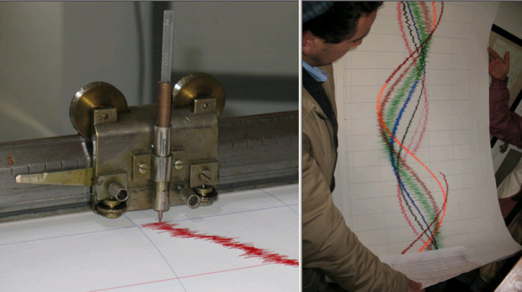
Esquerda: Poço e bóia.
Direita: Medição instantânea por régua. /
Left: well and buoy.
Right: Real time measurement.
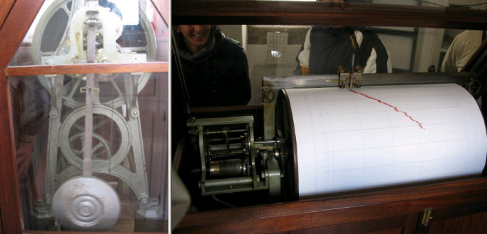
Esquerda: Relógio. Direita:
Tambor. / Left:
Clock. Right: Cilinder
Esquerda: Caneta. Direita:
Maregrama completo.
/ Left: Pen.
Right: maregram (7 days)
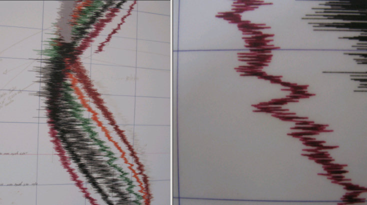
Esquerda: Maregrama da semana do Tsunami*.
Direita: Seicha**. Fenómenos recentes
(últimos 10 anos) ainda a serem estudados. /
Left: Maregram of the
Tsunami week*. Right: seiche**
* No
dia 26 de Dezembro de 2004 o registo do marégrafo detectou um
aumento anormal na amplitude das ondas durante alguma horas
(registo cinzento no maregrama da foto).
**
Seichas ou calemas são perturbações do nível das águas. No
caso da imagem, pode verificar-se que durante cerca de 10 a 15
minutos a maré, que estava a subir, passou a descer. Estes
fenómenos são preocupantes pois podem provocar acidentes com barcos
nos portos e têm sido verificados em marégrafos por todo o mundo.
Em lagos e superficies de água confinadas esse fenómeno é
conhecido, mas no caso do mar não é ainda compreendido. Estes
fenomenos são muitas vezes associados aos monstros
marinhos!
* On the 26th of
December 2004, the tide gauge detected an abnormal large amplitude
of the waves, during a few hours (grey line on the
maregram).
** seiches are unexpected
variations of the water level. In the photo you can clearly see
that, during 10-15 min. the tide suddenly stopped rising and began
lowering. These phenomena are dangerous because they can cause
accidents with boats in harbours, and they’ve been recorded all
around the world, although no one knows why. Seiches were known to
happen in lakes and confined water bodies, but not in the sea!
Sometimes people associate seiches with sea monsters passing
by!
Cache
Não
há muito a dizer: diverte-te!
Nothing to add except:
have fun!
Por favor não publiques fotos que identifiquem a
cache!
Please do not publish photos that may spoil the cache
search.