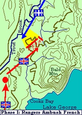
THE BATTLE ON SNOWSHOES: During the French and
Indian War, Lake George bore witness too many bloody skirmishes
between the French and Indians and scouting parties conducting
reconnaissance operations out of Fort William Henry and Fort
Edward. These scouting parties consisted of English Forrest
Rangers. Notable among these Rangers was the legendary Robert
Rogers.
On March 10th 1758, Rogers and his Rangers, a force totaling 184
men in all, departed from their camp on the island at Fort Edward
and began a 3 day hike up Lake George to conduct a reconnoitering
expedition against the French and Indian forces at Ticonderoga.
On the fourth day of the patrol, March 13th 1758, an advanced
guard spotted the enemy. A force approximately 96 strong composed
mostly of Indians, advancing along the banks of Trout Brook to the
Northwest of Bald Mountain. Rogers and his men immediately set up
an ambush. Lying in wait, Rogers and his men soon unleashed a
devastating ambush on this Indian force killing about 40 Indians
with the initial fire. Roger’s men then pursued the
retreating Indians and scalped about 40 more.
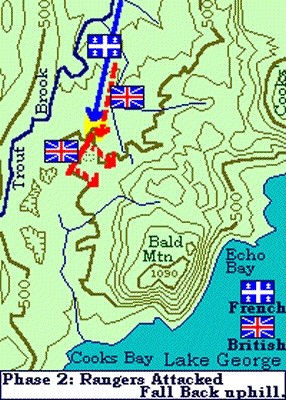
However, Unknown to Rogers, the French and Indians had in fact
started in two parties fifteen minutes apart. This second force,
composed of over 200 French Marines, now had the element of
surprise on their side. As such, they flanked Rogers and his
Rangers and ambushed them with equally devastating results.
As the French continued their counter-attack, Rogers realized
the dire situation he was in and ordered his remaining Rangers to
fall back toward high ground on Bald Mountain.
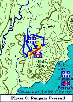
The French and Indians, sensing the vulnerability of Rogers and
his despised Rangers, pressed on with their attack pursuing Rogers
and his men up the high ground.
During this retreat, Rogers reportedly lost 50 of his men in the
attempt to reach the high ground on Bald Mountain.
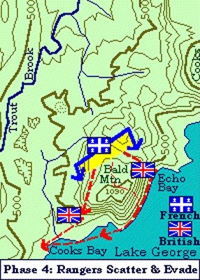
As darkness approached, Rogers in a last ditch effort to save
his men, ordered his remaining Rangers to disperse in an attempt to
evade the enclosing enemy forces. It is at this point in The Battle
On Snowshoes that Rogers supposedly made his legendary escape.
Although accounts vary, historians suggest that after having
climbed up the West slope of Bald Mountain, Rogers either reversed
his snowshoes or back tracked from the edge of the cliff in order
to fool his pursuers into believing he had gone over
“Roger’s Slide.”
Of the 184 men in Roger’s party, 125 men were killed in
The Battle On Snowshoes. The cache is hidden a short distance from
where Rogers allegedly made his legendary escape.
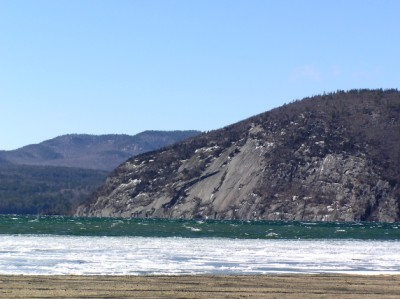
The Trail: Rogers Rock Campsite, while not open
for camping during the off season, is still accessable during the
winter for X-Country skiing, hiking, and access to the Lake for ice
fishing. When the Park is open you may have to pay a small day use
fee, but if you tell them you are hiking Rogers Rock they may let
you “slide.” Immediately after the booth, take the
first left which will loop back out towards the main road. Follow
this a short distance past the recycling station and boat wash area
and then take another left followed by another left and look for
campsite #210. Coordinates for site 210 are N43 47.815 W73 28.931.
During camping season you may have to park at the boat launch and
make the walk back to site 210. The trail starts in the woods
behind the site.
Although there is no officially marked trail to the top of
Rogers Rock, there is a well defined herd path that is marked with
cairns along the way. As an added safety measure, you may want to
turn on your GPS’s tracking feature and mark site 210.
At the rear of site 210, let your eyes pick up the natural path.
You’ll know you’re on it when in a very short distance
you will pass by the signs indicating the States property boundary.
Don’t worry, you don’t go on private property as the
trail veers away and towards Rogers Rock. After a short distance
the trail will drop off a small bank and you will be at the base of
a short but steep wall face. Follow along the base generally to the
North for about 50 yards until you come to a large fallen tree
blocking your path. Coordinates for this spot are N43 47.945 W73
28.720. From here you should see where the trail begins its climb
up the steep wall face. Just follow the cairns as the trail will
switchback its way up this short but very steep section. Hence the
4.5 star rating.
After this short climb, the trail soon reaches the height of
ground and is generally level the rest of the way to the cache. On
top it is a nice hike through mostly pine and oak and the trail
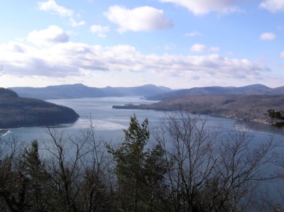
contours nicely around the outer rim offering splendid views of
Lake George’s Northern Basin. As you near the top of Rogers
Slide pay attention to the trail and cairns as there are a few less
defined paths that meander around. They will generally lead you to
the cache, but there is no need to turn this into a bushwack. The
cache is hidden about 50 feet from the trail.
As this cache is located near the campsite, I’ve stocked
it with items that may be of use while camping. It is a .50 caliber
ammo box. Distance from site #210 to the cache is just over 1 mile.
I hope you enjoy the adventure!