What does NAD27 and NAD83 mean exactly anyway?
NAD27 is short for North American Datum 1927 and NAD83 is short
for North American Datum 1983. A datum is a system by which
coordinates are measured. NAD27 is based on a model of the earth
defined by Clarke in 1866. This model assumes the earth is a
perfect sphere. Since 1866 it has been determined that the earth is
not actually a sphere, but rather an ellipse. The earth is flatter
at the poles than it is at the equator. What this means is that
NAD27 data is distorted and as one travels north from the equator,
the error becomes greater and greater. Since NAD27 was developed
long before the advent of GPS, it was simply possible to create
different NAD27 datum in different parts of the world. This
minimized the distortional error as well. In Canada we have 4
different NAD27 datum as well as a NAD27 Canada (mean) datum. When
you select this datum in your GPS, your shift from the
Manitoba/Ontario NAD27 datum is only about 3m. So how different are
coordinates in NAD27 and NAD83? Well, in Ottawa if you are using
the wrong datum, your position will be wrong by about 223 metres.
That’s a significant difference! So why was NAD83 developed? Simply
put, NAD83 can be used universally around the world. This is
important now that we have GPS since the same satellites are used
by GPS systems all over the world.
Okay, so now you understand datums. What’s this UTM and MTM
stuff all about?
UTM is short for Universal Transverse Mercator Projection. A
projection is the way a portion of the earth’s surface, which is
curved, is displayed on a flat plane with an X and Y axis. One
system is the Lambert Projection. This projection displays degrees
of longitude at a uniform width from north to south. Since in
reality degrees of longitude get smaller as we move towards the
poles, this creates a very distorted plane. You may recall seeing
maps of North America where northern Canada appears massive. These
maps use a Lambert Projection. A mercator projection divides the
earth into zones. In UTM 6 degree zones are used. The zones are
small enough that there is little distortion. This would be similar
to placing a postage stamp on an apple. At the edges of the stamp
there would be some distortion, while in the centre there would be
none. One method to improve this projection is to make it
transverse. What this means is that the projection slices through
the earth so that in the centre it is below the surface and at the
edges it is above the surface. Imagine shaving a round piece about
1 cm in diameter off the apple, then placing the stamp in the
centre and replacing the skin over top of it so the stamp sticks
out at the sides. There is some distortion in the centre of the
stamp, some in the edges, and none around the edge of the cut-out.
To account for the distortion, a scale factor is applied. This
factor differs at different locations and different elevations. In
Ottawa we normally use a factor of 0.999945. UTM creates a
coordinate system based on a Cartesian Plane. The distance north
from the equator is called the Northing. The distance from the
central meridian of the zone is called the Easting. In order to
avoid having negative Eastings west of the central meridian, the
meridian is assigned an arbitrary value of E 304800 metres (or
1000000 feet). This is called the False Easting. One way to further
minimize the distortion of a transverse mercator projection is to
divide it into smaller sections. UTM uses 6 degree sections. MTM,
short for Modified Transverse Mercator Projection, is used in
Ontario. This uses 3 degree zones, of which there are 9 zones.
These are more accurate for smaller areas. In Ontario we use NAD83
Datum and MTM coordinates for all survey work done by or for the
province. In Ottawa we use this system for work done for the NCC as
well.
Prior to 1995 it was still common to use NAD27 datum and MTM
coordinates in Ontario. The goal of this cache is to get you to set
your GPS to this system so that you can enter coordinates from a
1981 survey plan of a portion of the Greenbelt prepared for the
NCC. Using the following images, locate point number 30 on the
survey plan, then note the coordinates.


Next you must set your GPS to use this coordinate system. Here
is how I did it on my Garmin Etrex Legend.
1. Go to the setup menu, then select Units. Go to Position
Format.
2. Select User UTM Grid. You will now define a custom grid which
is actually MTM Zone 9. Set the options as follows and then save
it.
- Longitude Origin: W 76deg 30’. This is the origin of MTM Zone
9. - Scale: +0.9999. This is the scale factor locally. - False
Easting: 304800. This is used for all MTM zones and is arbitrary. -
False northing: 0. We accept the equator as being zero.

3. Now return to the Setup menu and select Map Datum. Scroll to
NAD27 Canada.
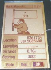
That’s it! Now when you look at your waypoints, they will be in
a Northing and Easting format. On my unit the Eastings are
displayed first and the Northings second. Your Northings should be
a 7 digit number with a format like 50xxxxx and the Eastings in a
format like 3xxxxx.
Here's an example:
Load your coordinate for point 30 on the survey plan and then
project it on a bearing of 318 degrees (True North) and 355 metres.
The cache is there. If you did everything right there is absolutely
no way you could miss it!