Boulders de peu del Montconill Multi-Cache
Boulders de peu del Montconill
-
Difficulty:
-

-
Terrain:
-
Size:  (regular)
Please note Use of geocaching.com services is subject to the terms and conditions
in our disclaimer.
 Català
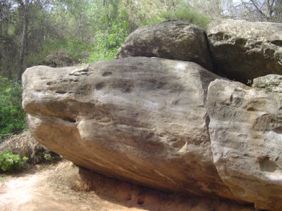
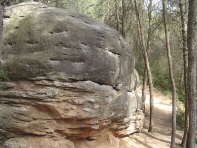
El Montconill és una muntanya de 482 metres a nivell del mar, a
l'est del Pla de Bages. Entre les poblacions de Sant Joan de
Vilatorrada i Callús. Éss una zona concorreguda per escaladors que
entrenen en aquests boulders.
És un multi-cache que consta de tres punts. En el primer, s'ha
d'anotar un número que servirà per arribar al segon punt. I en
aquest, hi ha un pot petit (de carret de fotos negre) amb les
coordenades del cache final. Tot i això, no resulta gaire
complicat, ja que en tot el trajecte hi ha caminets, els punts on
s'ha d'anar no queden gaire separats, i els passos estan bastant
detallats.
S'hi pot accedir des de Sant Joan de Vilatorrada, agafant la
carretera BV-3008, que va en direcció Fonollosa. En el km 3,150, en
el punt N 41º 45.048' E 001º 46.358' (WGS84), hi ha un
trencall cap a un camí de terra, que si es va en direcció a
Fonollosa queda a mà dreta just abans d'una corba també a la dreta.
És un camí bastant bo, i amb un turisme es pot fer perfectament. Si
es segueix uns metres el camí, en el punt N 41º 45.170' E 001º
46.289' (WGS84), hi ha un pal 'electricitat a la dreta del camí
on hi ha un número negre sobre una placa platejada. Aquest número
serà Y, que serà necessari per accedir al següent
punt.


Després d'anotar el número, es pot tornar a agafar el vehicle per
seguir el camí principal sense trencar en cap intersecció fins
arribar al punt N 41º 45.386' E 001º 46.301' (WGS84), on es
pot deixar el vehicle al costat d'un dipòsit d'aigua, al costat del
camí. A partir d'ara ja s'ha d'anar a peu.
Ara farà falta el número agafat abans, que s'ha dit que seria
Y. Per a calcular les coordenades del punt on hi ha el pot
petit, es farà a partir de:
N 041º 45.3[Y+3]0'
E 001º 46.11[Y]'
A partir d'això, s'ha d'anar a buscar el pot petit. Si s'ha fet bé,
hi ha caminets que van passant pel costat dels boulders que gairebé
hi porten directament. Està en un petit mur de mig metre
d'altura.
Quan es trobi el pot petit, a dins hi ha les coordenades el cache
final.


 English
The Montconill is a mountain of 482 meters at level of the sea, in
the east of the Pla de Bages. Among the populations of Sant Joan de
Vilatorrada and Callús. It's a zone coincided for climbers who
train in these boulders.
It's a multi-cache that consists of three points. In the first, a
number that will be useful for arriving to the second point has to
be noted down. And in this, there is a small jar (of black rollfilm
of photos) with the coordinates of the final cache. However, it's
not very complicated, since in all the route there are some ways.
The points where you have to go, do not come off very separate, and
the steps are quite detailed.
It can be accessed to from Sant Joan de Vilatorrada, taking the
road BV-3008, which goes in Fonollosa direction. In km 3.150, in
the point N 41º 45.048' E 001º 46.358' (WGS84), there is a
detour towards a dirt track, which if goes heading to Fonollosa
remains on the right before from a curve also to the right. It's a
quite good way, and with a tourism it can be made perfectly. If the
path is followed some meters, in the point N 41º 45.170' E 001º
46.289' (WGS84), there is a pole of electricity in the right of
the way, where has a black number about a silvery plaque. This
number will be Y, which will be necessary to access to the
following point.
After noting down the number, the vehicle can be taken to follow
the main way without turning in any intersection until arrives in
the point N 41º 45.386' E 001º 46.301' (WGS84), where the
vehicle can be left beside a water tank, beside the way. From now
already people have to go on foot.
Now the number taken before, which is Y, will be necessary.
To calculate the coordinates of the point where there is the small
jar, it will make itself from:
N 041º 45.3[Y+3]0'
E 001º 46.11[Y]'
From this, the small jar has to be gotten. If people have done
good, there some ways that they keep on going for the side of the
boulders that almost bring there directly. It's in a small wall of
half a meter of altitude.
When the small jar is found, inside there are the coordinates of
the final cache.
Additional Hints
(Decrypt)
[Català] - N yrf vzngtrf
[English] - Vagb gur vzntrf