
 Quem chega à Malcata, vindo de Penamacor,
ao parar em frenteao painel informativo à
entrada do parque é surpreendido pela desertificação deste espaço:
2 habitantes! Apenas 2 habitantes em 16 348 ha! A Reserva Natural
da Serra da Malcata foi criada em 1981 com o
objectivo primordial de
proteger o habitat do lince-ibérico, mas aqui os humanos também se
estão a extinguir!
A Serra da Malcata é
composta pelos seus montes arredondados, onde predomina o xisto, e
vales encaixados que constituem o leito de alguns dos nossos rios:
por aqui passa o rio Côa, para se juntar ao Douro, e nascem o rio
Bazágueda e a ribeira da Meimoa, para se juntarem ao Tejo. É
precisamente o Rio Bazágueda que vai poder conhecer nesta
“cachada”.
Ao caminhar pelas suas margens vai poder
apreciar a sombra dos: amieiros (Alnus glutinosa), freixo-comum
(Fraxinus angustifolia) e
salgueiros (Salix spp.).
Nas zonas mais secas poderá cruzar-se com: medronheiros
(Arbutus unedo) que dão os
deliciosos medronhos em Nov-Dez, e azinheiras (Quercus rotundifolia). A Norte da
serra predomina o carvalho-negral (Quercus pyrenaica), com as suas folhas
características que figuram estilizadas em todos os placards do
Parque Natural, já que são o símbolo do
I.C.N.
Os matos ocupam a maior extensão da Serra
da Malcata e são o habitat natural do lince-ibérico. Nestes locais
encontram-se a Norte: giesta-branca (Cytisus multiflorus) e giesta-amarela
(Cytisus striatus). A Sul
predominam: estevas (Cistus
ladanifer) de folhas pegajosas e grandes flores brancas de
cinco pétalas, carquejas (Genista
tridentata), e rosmaninhos (Lavandula pedunculata) que perfumam os
caminhos com o seu odor característico, e as suas flores roxas. A
urze-vermelha (Erica
australis) está a espalhar-se por toda a
serra.
Quem chega à Malcata, vindo de Penamacor,
ao parar em frenteao painel informativo à
entrada do parque é surpreendido pela desertificação deste espaço:
2 habitantes! Apenas 2 habitantes em 16 348 ha! A Reserva Natural
da Serra da Malcata foi criada em 1981 com o
objectivo primordial de
proteger o habitat do lince-ibérico, mas aqui os humanos também se
estão a extinguir!
A Serra da Malcata é
composta pelos seus montes arredondados, onde predomina o xisto, e
vales encaixados que constituem o leito de alguns dos nossos rios:
por aqui passa o rio Côa, para se juntar ao Douro, e nascem o rio
Bazágueda e a ribeira da Meimoa, para se juntarem ao Tejo. É
precisamente o Rio Bazágueda que vai poder conhecer nesta
“cachada”.
Ao caminhar pelas suas margens vai poder
apreciar a sombra dos: amieiros (Alnus glutinosa), freixo-comum
(Fraxinus angustifolia) e
salgueiros (Salix spp.).
Nas zonas mais secas poderá cruzar-se com: medronheiros
(Arbutus unedo) que dão os
deliciosos medronhos em Nov-Dez, e azinheiras (Quercus rotundifolia). A Norte da
serra predomina o carvalho-negral (Quercus pyrenaica), com as suas folhas
características que figuram estilizadas em todos os placards do
Parque Natural, já que são o símbolo do
I.C.N.
Os matos ocupam a maior extensão da Serra
da Malcata e são o habitat natural do lince-ibérico. Nestes locais
encontram-se a Norte: giesta-branca (Cytisus multiflorus) e giesta-amarela
(Cytisus striatus). A Sul
predominam: estevas (Cistus
ladanifer) de folhas pegajosas e grandes flores brancas de
cinco pétalas, carquejas (Genista
tridentata), e rosmaninhos (Lavandula pedunculata) que perfumam os
caminhos com o seu odor característico, e as suas flores roxas. A
urze-vermelha (Erica
australis) está a espalhar-se por toda a
serra.
 Se for paciente e
cauteloso poderá observar: coelhos-bravos (Oryctolagus cuniculus), raposas
(Vulpes vulpes), fuinhas
(Martes foina), ginetas
(Genetta genetta) e outros
pequenos mamíferos que vivem entre o matagal. No rio Bazágueda
existem: carpas (Cyprinus
carpio), lagarto-de-água (Lacerta schreiberi) e cágados
(Mauremys leprosa). Um
exemplar bem grande nada no rio junto ao açude onde se encontra a
cache! Finalmente, o bufo-real (Bubo bubo), a cegonha-preta
(Ciconia nigra) e o
pica-pau-verde (Picus
viridis) completam a fauna que usufrui deste rio. Se estiver
num dia de sorte poderá avistar o lince-ibérico (Lynx pardinus) mas nesse caso corra
para o telefone mais próximo e avise o I.C.N., pois no último censo
que se realizou na Malcata (em 2002) não se identificou nenhum
(!!!) lince-ibérico ou marcas da sua
passagem…
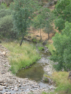
Ao longo do Rio Bazágueda,
como em muitos outros rios em Portugal, podem-se encontrar
vestígios de moinhos de água. Estes engenhos, a par com os movidos
a vento, foram abandonados assim que a indústria da panificação
surgiu na década de 50/60, derrotando-os numa guerra desigual.
Embora em ruínas ainda é possível adivinhar o seu
funcionamento… a montante era criado um açude permitindo
desviar uma pequena parte do rio por uma levada até ao moinho. A
água, passando por baixo da casa, deixava a sua força nas pás, que
presas a uma mó superior a faziam rodar sobre outra mó fixa. E
neste movimento o cereal, depois de escolhido, era moído, passando
por entre as grandes pedras circulares, para dar a preciosa
farinha.
Se for paciente e
cauteloso poderá observar: coelhos-bravos (Oryctolagus cuniculus), raposas
(Vulpes vulpes), fuinhas
(Martes foina), ginetas
(Genetta genetta) e outros
pequenos mamíferos que vivem entre o matagal. No rio Bazágueda
existem: carpas (Cyprinus
carpio), lagarto-de-água (Lacerta schreiberi) e cágados
(Mauremys leprosa). Um
exemplar bem grande nada no rio junto ao açude onde se encontra a
cache! Finalmente, o bufo-real (Bubo bubo), a cegonha-preta
(Ciconia nigra) e o
pica-pau-verde (Picus
viridis) completam a fauna que usufrui deste rio. Se estiver
num dia de sorte poderá avistar o lince-ibérico (Lynx pardinus) mas nesse caso corra
para o telefone mais próximo e avise o I.C.N., pois no último censo
que se realizou na Malcata (em 2002) não se identificou nenhum
(!!!) lince-ibérico ou marcas da sua
passagem…
Ao longo do Rio Bazágueda,
como em muitos outros rios em Portugal, podem-se encontrar
vestígios de moinhos de água. Estes engenhos, a par com os movidos
a vento, foram abandonados assim que a indústria da panificação
surgiu na década de 50/60, derrotando-os numa guerra desigual.
Embora em ruínas ainda é possível adivinhar o seu
funcionamento… a montante era criado um açude permitindo
desviar uma pequena parte do rio por uma levada até ao moinho. A
água, passando por baixo da casa, deixava a sua força nas pás, que
presas a uma mó superior a faziam rodar sobre outra mó fixa. E
neste movimento o cereal, depois de escolhido, era moído, passando
por entre as grandes pedras circulares, para dar a preciosa
farinha.
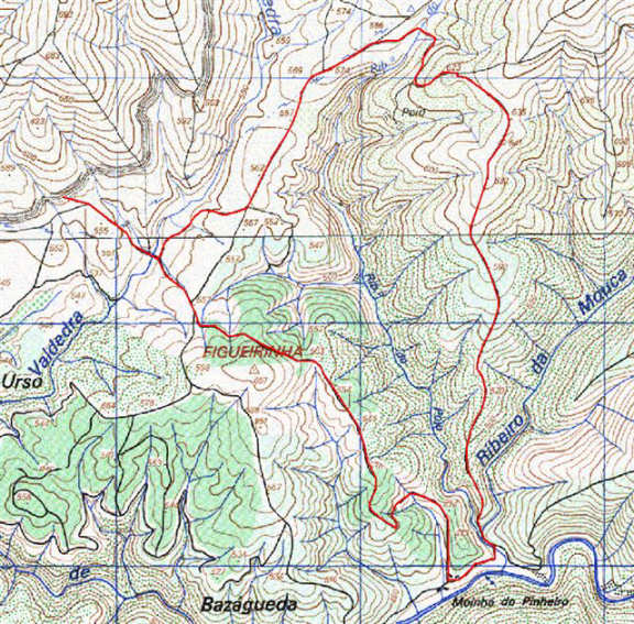
O percurso
pedestre
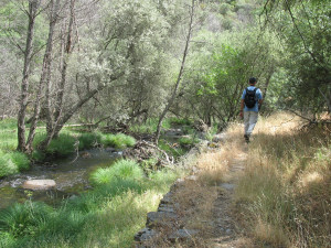
Para chegar ao local da cache não é necessário fazer o
percurso pedestre proposto, este é apenas uma sugestão! No entanto,
será sempre necessário caminhar alguns metros porque o local da
cache não é acessível a carros.
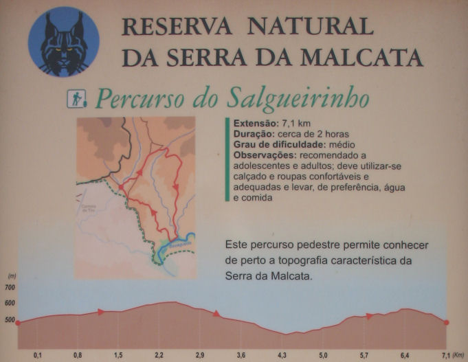
O “Percurso do Salgueirinho” trata-se de um percurso
circular, de dificuldade média, com extensão de 7,1 km e duração
prevista de 2 horas. Está perfeitamente assinalado por marcas
encarnadas e amarelas (sinalética
internacional). Também é possível fazer uma parte de carro, mas
é precisamente a meio, quando se encontra o rio, que a estrada se
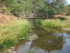
torna intransponível. Para quem vai a pé é fácil atravessar as
ribeiras pelas pontes de madeira que foram recentemente
construídas.
Durante o percurso, e já perto do local da cache, passa-se por um
moinho que já não funciona, mas que se encontra em perfeito estado
de conservação, já que pertence à senhora que vive na casa em
frente (um dos dois habitantes do Parque Natural!). Um pouco mais à
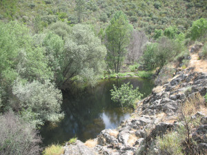
frente (ou atrás, dependendo do sentido) encontra-se o açude
pertencente a este moinho. Pode parar para apreciar a beleza do
local mas, se está com vontade de dar um mergulho, aguente mais uns
minutos, porque o local da cache reserva uma boa
surpresa!
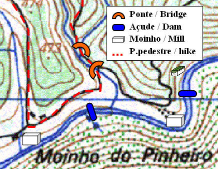
A
cache
Para chegar ao local da cache é necessário efectuar um pequeno
desvio no percurso pedestre. São cerca de 350 m de caminhada que
valem a pena!
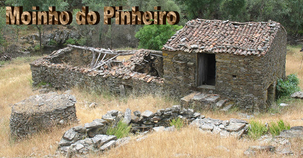
Passe para a margem esquerda do ribeiro da Mouca por uma das
pontes de madeira, e siga o caminho, até ao Moinho do Pinheiro, em
ruínas junto ao rio Bazágueda. Aqui pode apreciar o que resta das
habitações locais com o devido cuidado, pois estão a ruir. A
habitação mais intacta pertence ao antigo moinho, e ainda é
possível identificar um forno comunitário no exterior.
Encontre a levada, que conduzia a água até ao engenho, e siga-a até
ao açude. Sem passar para a outra margem procure a cache na
encosta, acima do açude. [spoiler]
Finalmente aproveite para se refrescar nestas águas
límpidas…
Atenção
A cache encontra-se num terreno
com declive acentuado, que se pode tornar perigoso quando
molhado. A profundidade do açude não
permite saltos para a água!

There is a big information panel, at the entrance of the
Malcata Natural Park, on the road that leads to Malcata from
Penamacor. The information is impressive: 2 inhabitants only in 16
348 ha of land! The Natural Park of Malcata was created in 1981 in
order to actively preserve the natural habitat of the iberian lynx,
but in here humans are also in danger of extinction!
Serra da Malcata is made up of several small hills of
schist, a sedimentary rock. The narrow valleys lead the rivers
across the Natural Park to their final destinations: river Côa
passes by to meet the river Douro a few km ahead, while river
Bazágueda and stream Meimoa are born in these hills. You will have
the chance to meet river Bazágueda in this cache hunt.
While walking on the banks of river Bazágueda you will be
able to appreciate the shadow provided by several trees: common
alder (Alnus glutinosa), narrow-leaved ash
(Fraxinus angustifolia) and willow (Salix spp.). In drier areas you may see: strawberry trees
(Arbutus unedo) which provide delicious fruits in
Nov-Dec, and “azinheiras” (Quercus
rotundifolia). In the Northern slopes there are many: pyrenean
oaks (Quercus pyrenaica), with its typical leaves
that you may find in all the information panels, since it is the
logo of the I.C.N. (Nature Conservation Institute).
Most of the Serra da Malcata is actually occupied by
Mediterranean bushes, that make up the perfect habitat for the
iberian lynx. In the Northern areas of the Park these are made up
of: white brooms (Cytisus multiflorus) and yellow
brooms (Cytisus striatus). To the South other
species predominate: laudanum (Cistus ladanifer)
with its sticky leaves and broad white flowers of 5 petals,
carquesia
(Genista tridentata), and spanish
lavenders (Lavandula pedunculata) which spread
their perfume all around. The spanish heath (Erica
australis) has been growing all over the Serra da
Malcata
If you are pacient and silent you may also observe: wild
rabbits (Oryctolagus cuniculus), foxes (Vulpes vulpes), stone martens (Martes
foina), common genets (Genetta genetta) and
other small mammals. In the river Bazágueda there are: common carps
(Cyprinus carpio), Schreiber’s green lizards
(Lacerta schreiberi) and mediterranean turtles
(Mauremys leprosa). There is actually a quite big
individual swimming in the river by the dam where the cache
is!
Finally, eagle owls (Bubo bubo), black
storks (Ciconia nigra) and green woodpeckers
(Picus viridis) can also be seen flying by the
river. If you are on a very lucky day, you may see an iberian lynx
(Lyns pardinus), but in that case run to the
nearest phone and warn the I.C.N. about it, because the last census
that was made in the Serra da Malcata (2002) retrieved zero (!!!!)
lynx found…
On the banks of the river Bazágueda, like in many other rivers in
Portugal, you may find old water mills. These were abandoned in the
late 50’s when the industry of bread developed. Although most
of the mills are in ruins, it is still possible to identify their
main parts: a small damn was created upstream to drive part of the
river water to the mill. Then, the water would pass under the mill
house, moving the wheel that would in turn make a heavy round stone
turn, over another stone, shattering the cereals. The final product
was the flour.
 The hike
There is no need to walk all the way to the cash location.
It is just a suggestion! But if you chose to use the car,
you’ll still have to walk a few hundred meters because the
exact spot is not accessible to cars.
The “Percurso do Salguerinho” is a circular
hike, of 7,1 km in length, which will take about 2 hours to
complete. It’s well marked along the way, with yellow and red
marks (international
code for hikes). You might drive a car through most of these
roads, but you cannot complete the hike driving, because there are
narrow wooden bridges over the river that can only be crossed
walking (or with a bike).
Along the hike, and when you’re approaching the cache
area, you will pass by an old mill that no longer works, but is
still standing firm, because it belongs to an old lady who lives in
the front door (one of the two inhabitants of the Natural Park!). A
few meters ahead (or before, depending on which direction
you’re hiking) you will find the dam that belongs to this
mill. You may take the time to appreciate the beauty of the place,
but if you’re willing to dive in the clear water, just hang
on for a few more minutes, because the cache spot has a good
surprise waiting for you!
The cache
To get to the cache spot you must make a small detour on
the marked hike. It’s only about 350 m and you’ll see
it’s worth it!
Use one of the wooden bridges to get to the left margin of the
“ribeiro da Mouca”. Follow the path to “Moinho do
Pinheiro”, which is in ruins. Here you can snick around the
place, and see all the old houses, but pay attention as some are
very old and might colapse. The house that is the best preserved
belongs to the old water mill. It is also possible to identify a
stone oven in front of the mill where the villagers would cook
their bread.
Find the water channel that used to lead the water to the mill, and
follow its way back to the dam. Go on walking through the slope by
the dam, until you find the cache. [spoiler]
Finally take your time and swim in the clear
water!
Pay attention
The cache is in a steep slope that might become
very slippery after/during rainy days.
Don’t jump into the water. The dam isn’t deep
enough!
Informações úteis / Useful Info

Quer saber mais
sobre o Geocaching
em Portugal?
Adere ao grupo de discussão e visita os sites
Geocaching@PT,
GeoPorStats e os mapas com a localização das caches
portuguesas
Would you like to
know more about Geocaching in Portugal?
Join the discussion group and visit
Geocaching@PT,
GeoPorStats and the maps with the location of the portuguese
caches