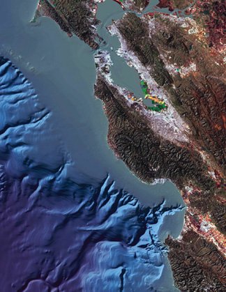
The Canyon
Monterey Canyon is a submarine canyon in Monterey Bay often
studied by the scientists at the Monterey Bay Aquarium Research
Institute and the Moss Landing Marine Laboratories.
Monterey Bay supports the termination of several rivers, creeks
and sloughs. These waterways include; Soquel Creek, Aptos Creek,
Watsonville Slough, Pajaro River, Elkhorn Slough, Moro Cojo Slough,
Old Salinas River, Salinas River, and Carmel River. The flow from
these waterways formed Monterey Canyon.
Monterey Canyon begins at Moss Landing, the middle of the
Monterey Bay, and extends approximately 95 miles into the Pacific
Ocean where it terminates at the Monterey Fan, reaching depths of
up to 3,600 m (11,800 ft) at its deepest. It is a part of the
greater Monterey Bay Canyon System, which consists of Monterey,
Soquel, and Carmel Canyons. The canyon's depth and nutrient
availability provide a habitat suitable for many marine life
forms.
The Cache
The cache is a camouflaged ammo can. The geocacher will realize
that there are certain times during the day or night that will
render the cache unobtainable. It will also become apparent that
special tools or equipment may be necessary to reach The Monterey
Canyon Cache. It may take more than one visit to the cache site to
successfully capture the smiley.
Parking and Access
There are two access points to the cache location. One at the
beach lot N 36 47.946 W121 47.355 and another near Phil's Fish
House (a nearby restaurant) at N 36 48.199 W121 47.285. There is
parking at or near each of these points.
Last Word of Caution
The cache location offers the potential for danger. The
geocacher may be placed in a position of exposure to high-surf,
cold water, unusual heights, and other oceanic oriented extremes.
Please use necessary caution and exercise responsible planning and
assessment in all aspects of the realization of this geocache.
CONGRATULATIONS!!! #1GeoBears "...I'm
pretty happy to get this FTF"