The Kilimanjaro Series was created to commemorate the
five year anniversary that my twin brother (
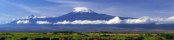
Mr. Echo) and I summited Mt. Kilimanjaro. Mt. Kilimanjaro is
located three degrees south of the equator in Tanzania. It is the
tallest mountain in Africa and is the highest free-standing
mountain in the world. This immense mountain is made up of three
volcanoes: Shira, Mawenzi, and our goal, Kibo, the tallest one in
the middle. There is a
virtual cache at the top, Uhuru Peak.
This series will take you along the route that we followed
(Machame Trail) and pose similar challenges. Mr Echo and I will own
these seven caches so some may also be in his name.

Listed below are the seven camps that we took and the seven
caches that we will set up
1. Machame Camp.
Elevation : 10,200ft Habitat: Montane Forest
2.
Shira Camp. Elevation : 12,600ft Habitat:
Moorland
3. Barranco Camp. Elevation : 12,700ft
Habitat: Semi-desert
4.
Karanga Camp. Elevation : 13,800ft Habitat:
Alpine Desert
5.
Barafu Camp. Elevation : 15,100ft Habitat:
Semi-desert
6.
Uhuru Peak (Summit). Elevation : 19,300 ft
Habitat: Glaciers
7.
Mweka Camp. Elevation : 10,200ft Habitat:
Forrest
This cache is the Machame Cache and is located at Camp Sloper in
Southington. It is the first 'camp' in the challenge. Pull into the
park and take your first right into a parking area for Memorial
Forest
On Kili, hiking to the Machame Camp takes you through the
rainforest and requires a guide who knows where you are going
because of the difficult terrain. Therefore, for this cache the
coordinates take you to a local ‘forest’ and require that you know
which way you are going. Standing at the center of the coordinates
(there is a structure there), face Southeast. The cache is about 50
feet in this direction.
