
 The Wukoki Pueblo is built on an outcrop of the Moenkopi
Formation. The Moenkopi was deposited sometime between 245 and
240 million years ago in the early Triassic. This Formation is
a red mudstone, siltstone, and sandstone. The sandstones
usually form the cliffs and weather into the flat rocks that
were used to build the pueblo. However you will find limestone
and black basalt pieces in the walls. These basalt pieces
would have come from the volcanoes of the San Francisco
Volcanic Field to the southwest, which includes Sunset Crater.
As part of the logging requirement, post a picture of one of
these pieces.
The Wukoki Pueblo is built on an outcrop of the Moenkopi
Formation. The Moenkopi was deposited sometime between 245 and
240 million years ago in the early Triassic. This Formation is
a red mudstone, siltstone, and sandstone. The sandstones
usually form the cliffs and weather into the flat rocks that
were used to build the pueblo. However you will find limestone
and black basalt pieces in the walls. These basalt pieces
would have come from the volcanoes of the San Francisco
Volcanic Field to the southwest, which includes Sunset Crater.
As part of the logging requirement, post a picture of one of
these pieces.
As you might expect with the variety of rock types in this
Formation, the Moenkopi was deposited in a variety of environments.
Some of these include shallow marine, beaches, tidal flats,
lagoons, and floodplains. These various environments and rock types
represent minor fluctuations in the sea level during the Triassic.
With such a variety of depositional environments, a variety of
sedimentary features can be seen in the beds of the Formation,
including ripple marks, mud cracks, raindrop impressions, cross
bedding, and fossil tracks. At the coordinates, you find ripple
marks covering almost the entire flat surface of the outcrop.
As wind or water moves over loose sediment it forms ripples. The
wind or water pushes individual grains of the sediment until the
grain piles up on each other. This forms mounds in rows that are
perpendicular to the direction of current is flowing
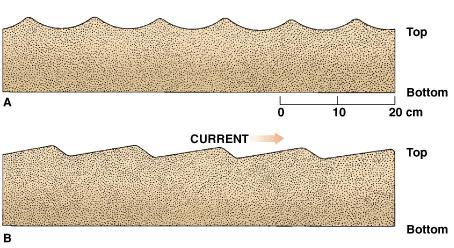 There are two types of ripples, symmetrical
(A in the diagram) and asymmetrical (B in the diagram).
Symmetrical ripples have the same slope on each side and are
formed by water moving back and forth, such as waves.
Asymmetrical ripples have one side steeper than the other and
are formed in flowing water, such as rivers and ocean
currents. The steep side of the ripple forms on the side the
current is flowing.
There are two types of ripples, symmetrical
(A in the diagram) and asymmetrical (B in the diagram).
Symmetrical ripples have the same slope on each side and are
formed by water moving back and forth, such as waves.
Asymmetrical ripples have one side steeper than the other and
are formed in flowing water, such as rivers and ocean
currents. The steep side of the ripple forms on the side the
current is flowing.
Flowing water over sand created these ripples. Then an influx of
additional sediment buried and preserved them
The second part of the logging requirement is to send me an
e-mail with the type of ripples you found, and the general
direction you think the water was flowing (assuming outcrop has not
been rotated)
Editorial review provided by Sara Hanson.
Logging requirements:
Send me a note with :
- The text "GCZ5W7 Wupatki Ripple Marks" on the first line
- The number of people in your group.
- Post a picture of a basalt or limestone rock in the wall of the
pueblo,
- E-mail me the type of ripples you found and the direction you
think the water was flowing.
The above information was compiled from the
following sources:
- Hanson, Sarah L. 2003, Roadside
Geology: Wupatki and Sunset Crater Volcano National Monuments,
Arizona Geological Survey, Down-to-Earth 15
- California State University at Long Beach,
2006, Environmental Clues in Sedimentary Rocks,
http://seis.natsci.csulb.edu/bperry/Sedimentary%20Rocks%20Tour/environmental_clues.htm
- Levin, Harold L.; The Earth Through Time
Seventh Edition,
http://www3.interscience.wiley.com:8100/legacy/college/levin/0470000201/chap_tutorial/ch03/chapter03-5sedstr.html
Placement approved by the
Wupatki National Monument