
 About 150 million years ago, the Farallon Plate was
subducting under the Pacific Plate. In this type of plate
collision, one plate (in this case the Farallon Plate) is
forced down into the earth as the other plate (the Pacific
Plate) rides up on top of the subducting plate. As the
subducting plate is forced further down, it heats up and
melts. The melted rock, magma, then began forcing its way up
to the surface in what can be described as a series of magma
filled balloons forming magma chambers deep undergound. Some
of these balloons found passages to the surface to create
volcanoes.
About 150 million years ago, the Farallon Plate was
subducting under the Pacific Plate. In this type of plate
collision, one plate (in this case the Farallon Plate) is
forced down into the earth as the other plate (the Pacific
Plate) rides up on top of the subducting plate. As the
subducting plate is forced further down, it heats up and
melts. The melted rock, magma, then began forcing its way up
to the surface in what can be described as a series of magma
filled balloons forming magma chambers deep undergound. Some
of these balloons found passages to the surface to create
volcanoes. 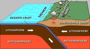 Current day plate boundaries that look like this are the Pacific
Northwest and the west coast of South America.Image
from: NPS
Current day plate boundaries that look like this are the Pacific
Northwest and the west coast of South America.Image
from: NPS
While the magma pushed its way up and while it remained molten
in the magma chamber, pieces of the surrounding Paleozoic
sedimentary rock (the country rock) were likely ripped off walls or
fell off the ceiling of the magma chamber. Many of these pieces
probably melted before the magma cooled, however a few pieces did
not melt completely and were encased in the granite when it cooled.
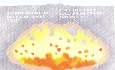 These foreign pieces of rock are called
xenoliths. The dark part of the rock in front of you is a
xenolith. Xenoliths can be found throughout the park. They can
be of any rock material and in a variety of igneous
rocks.
These foreign pieces of rock are called
xenoliths. The dark part of the rock in front of you is a
xenolith. Xenoliths can be found throughout the park. They can
be of any rock material and in a variety of igneous
rocks.
Image Source: Trent, D.D. & Richard W. Hazlett,
Joshua Tree National Park Geology, Joshua Tree National Park
Association, 2002
Photos: personal photo 2005
Once the entire Farallon Plate subducted under the Pacific
Plate, the source of magma for the magma chambers disappeared and
the magma began to cool to become large bodies of granite.

 Each of the individual bodies of granite is called a pluton. A
series of plutons created at the same time is called a batholith.
This pluton is in the Peninsular Batholith that stretches from Mt.
San Jacinto (near Palm Springs) down to central Baja
California.
Each of the individual bodies of granite is called a pluton. A
series of plutons created at the same time is called a batholith.
This pluton is in the Peninsular Batholith that stretches from Mt.
San Jacinto (near Palm Springs) down to central Baja
California.
Logging requirements:
Send me a note with :
- The text "GCZ5XA Peninsular Batholith Xenolith – Anza Borrego
SP" on the first line
- The number of people in your group.
- Send me a note with coordinates of another xenolith along the
trail. Include your reasoning for determining it is a
xenolith.
Now that you now what to look for, watch the rocks at your feet,
there is one just a little way back down the trail. It looks like
the picture with my foot in it.
The following sources were used to generate this
cache:
- Paul Remeika and Lowell Linsay,
Geology of Anza-Borrego: Edge of Creation, Kendall/Hunt Publishing
Company, Dubuque, Iowa, 1992
- Marty Grove, Oscar Lovera, and Mark Harrison,
Late Cretaceous cooling of the east-central Peninsular Ranges
batholith (33N): Relationship to La Posta pluton emplacement,
Laramide shallow subduction, and forarc sedimentation, Geological
Society of America Special Paper 347, 2003
- Trent, D.D. & Richard W. Hazlett, Joshua
Tree National Park Geology, Joshua Tree National Park Association,
2002
- NPS,
http://www2.nature.nps.gov/geology/tour/platetec.cfm">
- USGS, Visual Glossary,
http://geology.wr.usgs.gov/docs/usgsnps/rxmin/gxenolith.html