
 This earthcache attempts to show a regional feature that
stretches across many states. This would best be done from the
air or with hundreds of miles of driving, so please keep that
in mind when visiting this earthcache.
This earthcache attempts to show a regional feature that
stretches across many states. This would best be done from the
air or with hundreds of miles of driving, so please keep that
in mind when visiting this earthcache.
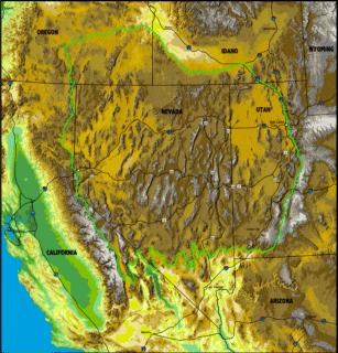
Antelope Island sits at the eastern edge of the Basin and Range
province. A geologic province is a region with similar geologic
features and processes. The Basin and Range province is
characterized by steep roughly parallel linear mountain ranges with
deep basins separating them. These basins have typically filled
with sediment to form flat deserts. The Basin and Range province
extends from eastern California to central Utah, and from Southern
Idaho to Sonora Mexico.
The Basin and Range province is the result of the stretching and
thinning of the earth’s crust that began about 20 million years
ago. Since then, the region has been stretched by as much as 100%
of its original width and appears to be continuing today at the
rate of about 1 cm/year.
Image source: Extent of Basin and Range,
Answers.com Image source: Shaded Digital
Elevation Model Data of Nevada, NASA
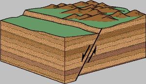
This stretching has pulled the California and Baja California
away from the center of the continent. As the crust pulled apart,
roughly north-south normal faults formed to accommodate the
extension. In a normal fault, the rock on one side of the fault
slides down the fault plane. In addition to one side sliding down
relative to the other, it also moves two points on the surface away
from each other creating the extension.
 Valleys formed in the down-dropped sides leaving
the high mountain ranges. These mountain ranges eroded into
the valleys filling them with sediment. Due to the thinning
and faulting of the earth’s crust this region also has
relatively common volcanism.
Valleys formed in the down-dropped sides leaving
the high mountain ranges. These mountain ranges eroded into
the valleys filling them with sediment. Due to the thinning
and faulting of the earth’s crust this region also has
relatively common volcanism.
Image Source: Normal fault, USGS
The coordinates are on one of the ranges, Antelope Island and
you can see the ranges to the east, the Wasatch Range, and west,
Carrigton and Stansbury Island. Beyond these islands to the west
are the Lakeside and Cedar Mountains. Both to the east and west the
Great Salt Lake has filled in the basins between these ranges.
(This might better be seen from the top of Frary Peak, but that
location is a challenge to hike up to. There are also a few
National Parks where features of the Basin and Range can be
observed
http://wrgis.wr.usgs.gov/docs/parks/province/basi.html.)
 The Basin and Range extension has also created
another large geomorphological feature, The Great Basin. The
Great Basin is an internal drainage, none of the surface water
drains to the ocean. This region includes a 200,000 square
mile area that includes Nevada, most of Utah, and portions of
Idaho, California, and Oregon. It is shown in orange on the
adjacent map. On the NASA shaded digital elevation model the
Great Basin is outlined in light green.
The Basin and Range extension has also created
another large geomorphological feature, The Great Basin. The
Great Basin is an internal drainage, none of the surface water
drains to the ocean. This region includes a 200,000 square
mile area that includes Nevada, most of Utah, and portions of
Idaho, California, and Oregon. It is shown in orange on the
adjacent map. On the NASA shaded digital elevation model the
Great Basin is outlined in light green.
Image: Great Basin outline, USGS
http://pubs.usgs.gov/of/1999/of99-425/webmaps/home.html
This region is not one single watershed but instead a number of
individual watersheds that drain to separate basins. Any
precipitation that falls in this region usually collects in one of
many short-lived lakes called playas and quickly evaporates or
percolates into the ground to become groundwater.
However, enough water and snow melt drain to the Great Salt Lake
to make it a permanent lake. On the average, the amount of water
that drains into the lake from the surrounding mountains during the
spring evaporates later in the summer. There are yearly
fluctuations that cause yearly changes in the lake level (See
Oolites of the Great Salt Lake Earthcache)
Logging requirements:
Send me a note with :
- The text "GCZ5ZC Basin and Range Province and Great Basin" on
the first line
- The number of people in your group.
- There are a few other island and peaks in and around the Great
Salt Lake. Send me a note explaining if these other islands are
part of the Basin and Range expansion or if they are
volcanic.
The above information was compiled from the
following sources:
- USGS, Geologic Provinces of the
United States: Basin and Range Province,
http://wrgis.wr.usgs.gov/docs/parks/province/basinrange.html
- USGS, A Tapestry of Time and Terrain: The Union
of Two Maps – Geology and Topography, The Basin and Range Province,
http://tapestry.usgs.gov/features/22basinrange.html
- Willis, Grant C. et al, Geology of Antelope
Island State Park, Utah in Geology of Utah’s Parks and Monuments,
2003 Utah Geological Association Publication 28 (second
edition)
- D.A. Sprinkel, T.C. Chidsey, Jr. and P.B.
Anderson, editors Flight Across the United States – Boston to
Denver to San Francisco, The Nevada Basin and Range; The Desert
Southwest; and The Snake River Plains, NASA,
http://rst.gsfc.nasa.gov/Sect6/Sect6_8.html
- USGS, Visual Glossary, Fault, Normal faults,
Reverse faults, Strike-slip fault, Fault scarp,
http://wrgis.wr.usgs.gov/docs/parks/deform/gfaults.html
- USGS, Open-file Report 99-425 online
version1.0, Geothermal Industry Temperature Profiles from the Great
Basin,
http://pubs.usgs.gov/of/1999/of99-425/webmaps/home.html