
 Here you will look at Oolites and historical changes in
the level of the Great Salt Lake.
Here you will look at Oolites and historical changes in
the level of the Great Salt Lake.
Oolites
The coordinates bring you to a beach made up of round tan to white
grains. These grains are called oolites. Oolites form by the
deposition of the mineral aragonite (calcium carbonate) around a
central core (picture an perl). The central core can be a small
mineral grain or a brine shrimp fecal pellet.  The image below shows an oolite cut in half
showing the concentric layers of calcium carbonate around a
central core.
The image below shows an oolite cut in half
showing the concentric layers of calcium carbonate around a
central core.
Image of magnified and xsection of oolite: Utah
Geological Survey,
http://www.ugs.state.ut.us/online/PI-39/pi39pg14.htm
Oolites are an indicator for the environment of the area. They
form in high-salinity, high-calcium waters. The oolite actually
forms in the shallow waters of the lake and are washed ashore. Some
oolites have been blown up from the shore into dunes on the
landward side of the parking area.
Not all the sand dunes on the island are made up of oolites.
Elsewhere on the island quartz sand dunes are present, but are
related to Gilbert lake level (see Ancient Shorelines of Lake Bonneville ) when
the lake was not as salty.
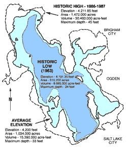
 Historic Lake Levels
The level of the Great Salt Lake is constantly changing. Water
flows into the lake from rivers, streams, precipitation and
groundwater. There is no outlet to the Great Salt Lake, so the only
water leaves the lake is through evaporation. When the rate of
inflow exceeds the evaporation, the level of the lake increases.
When evaporation exceeds inflow, the level of the lake
decreases.
Graph Source: Utah Geological Survey,
http://www.ugs.state.ut.us/online/PI-39/pi39pg04.htm
Historically, the level of the lake has varied by about 20 feet.
Even this small variation, has resulted in large changes in the
lakes area because of its very shallow depth.
Image Source: Utah Geological Survey,
http://www.ugs.state.ut.us/online/PI-39/pi39pg04.htm
Even in a normal year the level of the lake fluctuates 1 to 2
feet each year. This is due to a decrease in evaporation and
increase in inflow from snowmelt during the winter and spring, and
an increase in evaporation and decrease in inflow during the summer
months. As a result, the lake is usually at its highest in May
through July and at its lowest in October through November.
 My visit was in Mid-October so I had to walk
quite a distance to the water’s edge. My coordinates for the
water’s edge was N 41 3.064 W 112 15.319.
My visit was in Mid-October so I had to walk
quite a distance to the water’s edge. My coordinates for the
water’s edge was N 41 3.064 W 112 15.319.
This image shows all the logged locations. Click on it for a
larger image. The points are color coded by season as follows:
- Blue - January to March
- Green - April to June
- Red - July to September
- Yellow - October to December
Image Source: Google Earth
Logging requirements:
Send me a note with :
- The text "GCZ5ZN Oolites of the Great Salt Lake" on the first
line
- The number of people in your group.
- Walk out from the parking lot toward my coordinates for the
edge of the lake. Post your GPS coordinates for the edge of the
lake.
- Include pictures if you have them. (I will accept alternatives
if your are physically unable to get out there).
I will use the coordinates to update the map and show the changes
in the lake elevation over time.
The above information was compiled from the
following sources:
- Utah Geological Survey, Great
Salt Lake, PI-39 Commonly Asked Questions About Utah’s Great Salt
Lake and Ancient Lake Bonneville,
http://www.ugs.state.ut.us/online/PI-39/pi39pg14.htm and
http://www.ugs.state.ut.us/online/PI-39/pi39pg04.htm
- Willis, Grant C. et al, Geology of Antelope
Island State Park, Utah in Geology of Utah’s Parks and Monuments,
2003 Utah Geological Association Publication 28 (second edition)
D.A. Sprinkel, T.C. Chidsey, Jr. and P.B. Anderson,
editors