The Walls of Jericho is a 750-acre natural area that is within
the 8,943-acre Bear Hollow Mountain Wildlife Management Area (WMA),
which is contiguous to the Skyline WMA in Alabama. Both of the
public lands on the Tennessee and Alabama side total 21,453 acres.
The natural area is approximately twelve miles south of Winchester
in southern Franklin County. The southern boundary of the natural
area follows the Alabama Tennessee state line where the actual
“Walls of Jericho” is located.
As a courtesy to my fellow cachers, I have placed the questions
you need to answer at the beginning of this page, so that they do
not get truncated by gps units that can only display a limited
amount of text in the description. Please take a moment to read
through the rest of the description to discover why this place is
so special, thank you. Your quest to log this earthcache involves
four parts:
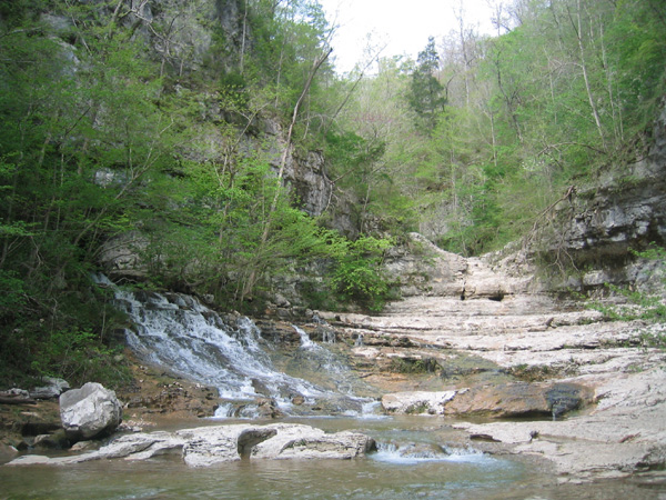
1. Hike to the "cathedral" and estimate it's width and depth.
2. Locate the cave entrance on the north side of the cathedral
with the stream emerging from it and calculate the approximate
depth of the water as it exits the cave. DO NOT enter the
cave.
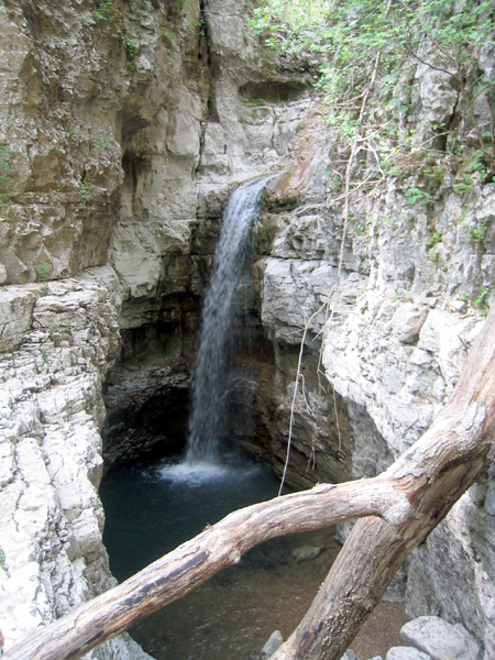
3. Proceed to the grotto at the head of the canyon to locate the
point where Turkey Creek becomes a disappearing stream. Take a
picture of the grotto and waterfall with yourself and/or your gps
in the photo.
4. Based on your observances at the grotto where Turkey Creek
disappears into the ground and the cave in the Cathedral where it
reemerges, is the water flow consistent? In other words, is there
as much water flowing out of the cave as there is disappearing into
the grotto? What does your answer tell you about the underground
drainage features of this area?
The “Walls” is an impressive geological feature that forms a
large bowl shaped amphitheater. Embedded in the limestone are
bowling ball size holes from which water drips and spouts, creating
a unique water feature. This amphitheater gives rise to steep
200-foot sheer rock walls that creates the natural feature defining
the amphitheater. Turkey Creek drains through the “Walls” and has
been an active geological force in creating the amphitheater. The
natural area forest is comprised of maples, oaks, hickories, tulip
tree, American beech, eastern red cedar, and many other plants
commonly associated with limestone. The forest land beyond the
“Walls” feature is noteworthy with its many bluffs, large rock
outcroppings, caves, and sinkholes.
Not only is the “Walls” significant as a geological feature, the
natural area is also important because of its biological richness.
The Turkey Creek drainage, which bisects the natural area from
north to south, supports the state endangered rare limerock
arrowwood (Viburnum bracteatum). This is one of only three known
occurrences in the state. Other rare species occur in the Turkey
Creek watershed. The protection of Turkey Creek also helps protect
downstream the Upper Paint Rock watershed where numerous rare
mussel and fish species occur in the Paint Rock River.
The "cathedral" is a 150-foot-wide natural amphitheater sits
between 200-foot-tall walls. It gets its name from a traveling
minister who found it in the late 1800s and the cathedral-like
beauty so captivated him that he declared it needed a biblical
name. The Walls of Jericho is the name for this entire mile long
canyon with it's sheer 200 foot walls. While hiking within the
walls you will be following Turkey Creek which has carved this
canyon over millions of years, but as you reach the cathedral, you
will note that no water appears to be flowing down the canyon from
above this point. This earthcache will teach you about
"disappearing streams" and how they play into the geological
landscape.
The Walls of Jericho geological feature is a prime example of
the stark beauty that can be found in limestone karst landscapes.
Throughout the world karst landscapes vary from rolling hills
dotted with sinkholes, as found in portions of the central United
States, to jagged hills and pinnacle karst found in the tropics.
The development of all karst landforms requires the presence of
rock which is capable of being dissolved by surface water or ground
water. The term karst describes a distinctive topography that
indicates dissolution (also called chemical solution) of underlying
soluble rocks by surface water or ground water. Although commonly
associated with carbonate rocks (limestone and dolomite) other
highly soluble rocks such as evaporates (gypsum and rock salt) can
be sculpted into karst terrain.
Understanding caves and karst is important because ten percent of
the Earth’s surface is occupied by karst landscape and as much as a
quarter of the world’s population depends upon water supplied from
karst areas. Though most abundant in humid regions where carbonate
rock is present, karst terrain occurs in temperate, tropical,
alpine and polar environments. Karst features range in scale from
microscopic (chemical precipitates) to entire drainage systems and
ecosystems which cover hundreds of square miles, and broad karst
plateaus.
Karst Topography
The degree of development of karst landforms varies greatly from
region to region. Large drainage systems in karst areas are likely
to have both fluvial (surface) and karst (underground) drainage
components. As stated in the introduction, the term karst describes
a distinctive topography that indicates dissolution of underlying
rocks by surface water or ground water.
Water falls as rain or snow and soaks into the soil. The water
becomes weakly acidic because it reacts chemically with carbon
dioxide that occurs naturally in the atmosphere and the soil. This
acid is named carbonic acid and is the same compound that makes
carbonated beverages taste tangy. Rainwater seeps downward through
the soil and through fractures in the rock responding to the force
of gravity. The carbonic acid in the moving ground water dissolves
the bedrock along the surfaces of joints, fractures and bedding
planes, eventually forming cave passages and caverns. Limestone is
a sedimentary rock consisting primarily of calcium carbonate in the
form of the mineral calcite. Rainwater dissolves the limestone by
the following reaction: Calcite + Carbonic acid = Calcium ions
dissolved in ground water + Bicarbonate ions dissolved in ground
water. Cracks and joints that interconnect in the soil and bedrock
allow the water to reach a zone below the surface of the land where
all the fractures and void spaces are completely filled (also known
as saturated) with water. This water-rich zone is called the
saturated zone and its upper surface is called the water table. The
volume of void space (space filled with air or water) in soil or
bedrock is termed porosity. The larger the proportion of voids in a
given volume of soil or rock the greater the porosity. When these
voids are interconnected, water or air (or other fluids) can
migrate from void to void. Thus the soil or bedrock is said to be
permeable because fluids (air and water) can easily move through
them. Permeable bedrock makes a good aquifer, a rock layer that
holds and conducts water. If the ground water that flows through
the underlying permeable bedrock is acidic and the bedrock is
soluble, a distinctive type of topography, karst topography, can be
created.
Here in Tennessee doline karst is the dominant feature. Doline
karst is the most widely distributed type of karst landscape. The
landscape is dotted with sinkholes (dolines) which can vary widely
in number and size, in fact you will pass a very large example of a
doline and several smaller ones while hiking in to the Walls of
Jericho area. Karst topography dominated by sinkholes or dolines
usually has several distinct surface features. Sinkholes (also
known as dolines) are surface depressions formed by either: 1) the
dissolution of bedrock forming a bowlshaped depression, or 2) the
collapse of shallow caves that were formed by dissolution of the
bedrock. These sinkholes or shallow basins may fill with water
forming lakes or ponds. Springs are locations where ground water
emerges at the surface of the earth. Disappearing streams are
streams which terminate abruptly by flowing or seeping into the
ground. Disappearing streams are evidence of disrupted surface
drainage and thus indicate the presence of an underground drainage
system. It is clear in this case that surface drainage has been
disrupted, since Turkey Creek whose erosional forces helped to
create this canyon, no longer flows down the canyon, but through
the cave system below it.

Moving water may transport earth materials into and through caves
physically or chemically. Caves contain interesting features as a
result of the physical and chemical processes that form them. Among
these features are breakdown blocks of rock formed by collapse of
cave ceilings. Also seen are sediments containing boulders, sand,
silt, and clay deposited from water flowing in and through cave
passages and conduits. Speleogens are irregular or distinctive
shapes of carbonate rock etched from bedrock by dripping or running
water. Speleogens can form where bedrock is not uniform in chemical
composition. Consequently, the less soluble rock dissolves slower
than adjacent more soluble rock through time. The less soluble rock
tends to stand in relief and projects from walls and ceilings of
caves.
Away from their entrances, caves usually provide a relatively
constant temperature and humidity over a long period of time. Thus,
caves provide an ideal environment for chemical deposition of
minerals. As water laden with dissolved carbonate seeps into the
air-filled cave passage, it may lose excess carbon dioxide to the
cave atmosphere, or the water itself may evaporate, causing the
dripwater to precipitate secondary carbonate or other minerals from
solution, creating cave formations or speleothems including
cone-shaped stalactites, stalagmites, flowstone or rimstone, or
other interesting shapes. Caves in karst areas often have
stalactites (icicle-like masses of chemical limestone) that hang
from cave ceilings and stout stalagmites protruding from the cave
floor. Stalactites and stalagmites can be a few inches to several
feet long. Sometimes the drip water will flow down the walls and
over the cave floor creating flowstone or rimstone deposits. Where
drip water seeps from a joint and then drips over the edges of
ledges, deposits of great complexity known as draperies are formed.
The color of dripstones and flowstones comes from organic and/or
iron oxide compounds brought in from the surface, giving the
speleothems an orange brown color or from the presence of oxides
and hydroxides of iron and manganese which give the speleothems a
deep brown or black color.
The Hike In
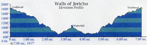
The hike is about 7 miles in length, roundtrip, and is downhill
most of the route into the gorge. That, of course, means the walk
back will be mostly uphill. It is a strenuous hike, so you should
wear comfortable shoes and take plenty of water and snacks. The
trail is well marked but often is muddy for days after a rain
shower. Several streams have to be crossed, so plan on getting wet.
Be advised that stream levels rise quickly during thunderstorms and
crossing them can be hazardous in swift water. Plan on a minimum of
six to seven hours to make the round trip, which includes a
two-hour stay in the gorge. If you want an idea of what kind of
elevation change I am talking about just check out this profile.
This is from our gps track going in taking the left fork and wading
and coming out over the footbridge.
Just a couple of more quick notes, the trailhead and parking for
hikers are actually in Alabama about a mile south of the border at
N 34 58.620 W 86 04.820, parking for horse trailers is about a mile
further south. There is plenty of parking available at the
trailhead. There was something cool about hiking from one state to
another, I know that it is no big deal but I thought it was cool.
While driving in from Tennessee we passed a new TWRA Walls of
Jericho Trailhead on the Tennessee side of the border, but I did
not have a trail map for that one so we went with what we knew, the
next time I am down I will try that trail and let you know if it is
finished. Be sure to take your time and look around while you are
hiking in and out. There are all kind of cool things along the
trail including a very cool hollow log stream crossing, several
caves and all kinds of wildlife. I was amazed at how quickly the
environment changed from old growth forest, to underbrush to karst
to boulder fields to stream and meadow and back again. Although I
was dog tired at the end of the day, the views are well worth the
hike, I hope you enjoy the Walls of Jericho as much as I did, I
look forward to seeing you on the trails.
To log this EarthCache:
Email your answers to me and post your photo to the webpage to
log this earthcache. Here is an example of the sort of picture you
should take at the grotto:

