View from the Visitors
Center
Directions: Dead Horse Point is on State Route 313, 18
miles off Highway 191 near Moab. You can drive out to the point or
you can take the trail from the Visitors Center.
Supplies: Water, camera, something that shows the rock
strata.
Objectives:
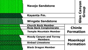
- To learn to identify 3 main members of the rock column in the
Canyonlands area;
- To learn something about nearby mining activies;
- To learn the origin and destination of the Colorado
River.
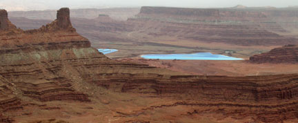
The Kayenta is a bench former. Good thing, ‘cause it’s holding
you up as you grip the railing and stare at the Colorado River
meandering 2000 feet below. Two vistas are especially awesome: the
view over the river from the observation point at the very tip of
the point, and the view to the east from the Visitors Center. Take
the short loop behind the Visitors Center and identify the numbered
plants and rocks. Can you find some Mormon Tea? Hint: It's not
in the vending machines!
Educational Requirement: To get
credit for this EarthCache you must email us your answer to any one
of the Study Questions and let us know how many people were in your
party.
Study Questions
- College-bound AP Where does the water in the Colorado
River come from? Where is it going?
- College-bound AP Name the major layers starting with the
one you are standing on, down to the Colorado River. Pick out the
layers most- and least resistant to erosion.
- Freshman How can you identify the Chinle Formation? What
is it made of?
- Freshman Where are the Navajo and Entrada sandstones?
Why? Where did they go?
- Graduate What are those incredibly blue ponds over to
the east?
- Ph.D.What geological events led to the mineral deposits
recovered in those ponds? How do the minerals get to the
surface?
Wikipedia
on the geology of the Canyonlands area
Wikipedia on the
Colorado River
Intrepid Potash Mine
There is a dazzling 10-minute silent fly-over video with aerial
views of the region, the evaporation ponds, and the mining process.
It is a large file and loads slowly.
Good
information for tourists and campers
Rick Mazey’s Geology
Notebook
Name those
Strata!
Detailed
Geological Timescale
Visitors’
Information
Utah Travel &
Adventure
Geologic History of Utah. Lehi F. Hintze. Department of Geology.
Brigham Young University, 1988.
Geology of Utah. William Lee Stokes. Utah Museum of History,
University of Utah and Utah Geological and Mineral Survey,
Department of Natural Resources, 1986.