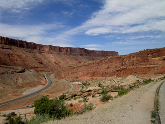
View from the Turnout
The Moab Fault is a nearly vertical, normal fault (see links
below) in the Paradox Basin of southeastern Utah. Geologists
believe it occurred as the result of the dissolution-migration of
subterranean salts (the Paradox evaporites) laid down by inland
seas during the Pennsylvanian Epoch, ~300 million years ago
(Mya).
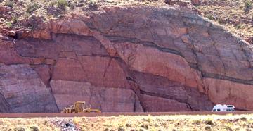
Complex "fractal" faulting in the Hwy. 191 Roadcut
Objectives:
1. To see in your mind's eye the earth movement that created the
Moab Fault;
2. To identify the major geological layers (strata) exposed in
the region.
Directions: Enter Arches NP north of Moab from Highway
191. Follow the switchbacks to the first turnout at the posted
coordinates. Be sure to read the colorful descriptive plaque.
Supplies: Stop at the Visitors Center and pick up a free
pamphlet that identifies the different rock strata. You will refer
to it as you tour the Park and nearby attractions.
As you search for answers to the Study Questions, use Wikipedia
or Google for a starter; put quotation marks around compound
phrases, such as "hanging wall".
Educational Requirement: To get
credit for this EarthCache you must email us your answer to any one
of the Study Questions and let us know how many people were in your
party.
STUDY QUESTIONS:
The Study Questions are arranged by our adaptation of the Asimov
ratings. Isaac Asimov wrote quizzes for daily newspapers over many
years. The difficulty of the questions was classified as
"Freshman", "Graduate" or "Ph.D."
1) AP College-Bound. Are the nearly vertical red cliffs
on the west side of the highway the same formation as those to the
east (in Arches NP)? If not, why not? Has some rock "gone missing"
? Where do you suppose it went?
2) Freshman. Look at this Earthcache on Google Maps;
bring up Satellite and Hybrid views and find Arches NP. Can you
identify the Moab Fault? How do you know it's a fault?
3) Freshman. Why are some of the rock layers nearly
vertical, while others form slopes?
4) Graduate. Name some of the features that help one
distinguish one layer/formation from another.
5) Graduate. What is a “normal” fault? Did
Arches go up or did it go down? Kinds of Faults
Also, check out the Animation under Links and Resources below.
ADVANCED QUESTIONS:
6) Ph. D. Are you standing on the hanging wall or the
foot wall? Kinds of
Faults
7) Ph.D. Assuming that you are standing on the Navajo
formation and that you are eye-level with the bottom of the Wingate
formation across Hwy. 191, how far would you estimate one side of
the fault moved relative to the other?
Links and Resources:
What are those strata? The NPS page that showed the strata is
under review. This older figure is rich in information but hard to
read.
Robert J. Lillie. Parks and Plates. The Geology of our National
Parks, Monuments and Seashores. WW Norton, New York, 2005. Publisher's
Advertisement
An animated explanation of geological faulting.
View Animation